Книга: A Different Kind of Freedom
A Different Kind of Freedom
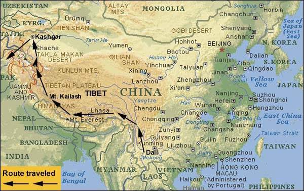
The route starts in southwestern China, in the rural town of Dali, just to west of Kunming, Yunnan. This area forms the eastern terminus of the great Himalayas, the start of the journey. From there it goes northwesterly into the eastern part of Tibet, locally known as Kham. The high forested mountains and valleys of Kham finally give way to the area of central Tibet and the capital city, Lhasa. Leaving Lhasa the road goes toward Mt. Everest and just before reaching the Nepal border a dirt track points the way to the holy Mt. Kailash of Western Tibet. From this most scared pilgrimage site, the main road goes northwesterly through Ali, then across one of the highest most desolate roads in the world, crossing the Askin Chin basin. After descending from this 16,500 foot basin, the Kunlan Shan Mountains are one of the last obstacles before reaching Kashgar in far western China. The Karakoram Highway connects this silk road town with Pakistan and is followed to the final ending point of Gilget, Pakistan. The entire route covers a distance of more than 3,300 miles (5,500 KM).
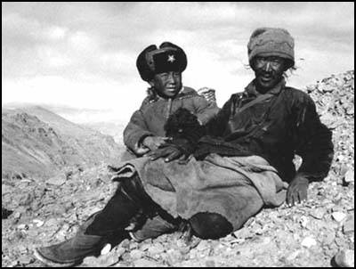
“They lived on old hard, dried raw meat, butter, sour milk and brick tea. They made boots and straps of the wild asses skin, and thread from the tendons of the wild beast. They and their women took care of the tame yaks, the sheep and the goats. Thus their lives passed monotonously, but healthily and actively, from year to year, on dizzy heights, in killing cold and storm and blizzards. They erected votive cairns to the mountain gods, and venerated and feared all the strange spirits that dwelt in the lakes, rivers and mountains. And in the end they died and were borne by their kin to a mountain, where they were left to the wolves and the vultures.”
– My Life As An Explorer, Sven Hedin, the first Westerner to circumambulate Mt. Kailash, 1907
Flying along at 30,000 feet [9100 meters] above the Pacific Ocean, I sat on a China Air flight from Taipei, Taiwan to San Francisco. The Boeing 747 carried me home from a ten-month trip through Asia. At first what had seemed like a haphazard course through most of Asia, in retrospect was a great circuit around the Himalaya traveling through Nepal, India, Thailand, China and Tibet. The 13-hour flight seemed to last for days. While the daylight outside the plane changed to night and back again, I planned what would consume my being and my life for the next two years.
I had a simple idea in mind. I wanted to ride the greatest mountain bike route in the world. A 3300-mile [5500 km] solo ride that would follow the length of the massive Himalaya. It started in southwestern China, in the province of Yunnan, where the Himalaya end near the Chinese-Burmese border. From there I would stay on the north side of the Himalaya and cycle the length of Tibet, finishing on the other end of the great ridge, where Pakistan, China, and Afghanistan all come together. The route would take me to Lhasa, the capital of Tibet, and former home of His Holiness the 14th Dalai Lama, the religious and political leader of Tibet. From Lhasa I would follow one of the centuries-old trade routes out to the most sacred mountain in Asia, Mt. Kailash in Western Tibet. Then the last leg would lead me to Kashgar, the hub of the silk road in Central Asia, on one of the highest, most desolate roads in the world.
When my plane landed in San Francisco, I hopped on the bus down to Palo Alto and walked the seven miles up to where I had been living. Maybe I had been in Asia too long, but somehow walking that last remaining portion of my trip home seemed like the right thing to do. I picked up a pint of Ben amp; Jerry’s Toffee Heath Bar Crunch ice cream en route, a treat impossible to find on the other side of the planet. Sometimes there is no place like the USA! I could not have planned it any better. When I got home my housemates anticipated having Thanksgiving dinner in another hour, they had no idea that I was returning from Asia, I wanted to surprise them all. By American standards we ate a normal Thanksgiving dinner, but compared to where I had been only a couple weeks before we enjoyed a royal feast.
I worked as a consultant in Silicon Valley for the last few years, doing easy jobs and receiving great wages. Before I knew it, I had begun work at another software consulting job. I spent a few hours a day programming UNIX computers, writing software to control large-scale telephone switches for fiber optic long distance telephone networks, then continue with the research for my trip. At four in the afternoon I headed home for a strenuous mountain bike ride and to study spoken Chinese in the evenings. I had picked up a little Chinese and Tibetan on my last trip but I knew I needed a much greater proficiency of both languages. On the trip I had planned I anticipated that I would go for weeks without speaking English. I knew that I must be conversational in Chinese. Every day during my standard San Francisco Bay Area commute I listened to Chinese language tapes, practicing to myself in Chinese “Hello, are you Comrade Chen?” “No, I’m not Comrade Chen.” In the evenings I conversed with an American-born Chinese housemate, each of us jokingly addressing the other as “comrade”.
I love maps. In my living room an enormous map of the world covers an entire wall. I sit and daydream for hours, checking out different places on this map. Maps of Tibet are always difficult to come by. I could not just call up American Automobile Association and ask, “Could you make me up one of those trip-tic things for a trip across Tibet?” I wanted to start down in Dali, Yunnan, China, head through Lhasa, Mt. Kailash, and on to Kashgar. If this was an easy task, everyone would be setting out this ride. After a couple months, I finally tracked down a set of US military maps that cover the entire planet, called Observational Navigation Charts or ONC maps. When I received my copies, I pinned the 6 foot by 8 foot [2 meter by 2.5 meter] section of the ONC maps to the wall adjacent to my world map. I quickly realized that these maps were intended for jet fighter jocks. Over parts of the map covering North India and Western China there were boxes reading “Aircraft Infringing upon Non-Free Flying Territory may be fired on without warning.”
By most every measure, I lived an easy life in California. I had delicious food to eat, a warm place to live, and just about all the material comforts that I could ever want. Twenty-four hours a day, I could go to a supermarket to get as much ice cream as I could eat. I could pick up a phone and have someone deliver a hot pizza right to my house. I truly lived the life of royalty. Somehow in all this luxury, part of the challenge of life disappeared. It seemed to me that the life of hardship that I would face in Tibet would balance out the life of material ease that I had enjoyed in California. I do not think I would have sought out such a demanding journey if my life in the USA had not been so comfortable.
On a roadside billboard, advertising a shopping mall, I have seen a sign that reads, “Over 100 stores, over a million choices.” Sometimes this is one of the problems with the USA, you are inundated by choices, thousands and millions of choices everyday. It seems that most every consumer activity involves far too many decisions. I have often seen people suffer from what I have heard referred to as “Analysis Paralysis.” This common malady can often manifest during any type of shopping activity. On a simple trip to get something to drink at Safeway, an entire aisle of varying types of bottled water bombards you with choices. It seems that when so many choices of virtually identical products overload your brain you become paralyzed by the process of trying to make an intelligent decision. There is something to be said for life in the third world where far more simple choices abound. I am not sure that I always need 72 different types of oatmeal to choose from.
List of equipment, list of things to do, list of lists. I had an unending list of tasks that I needed to do before I took off for China, buying a water filter, tools, building my bike, on and on. As my departure date I chose April 1, 1994. The seasons in Tibet had determined the date. Much later I would learn that there would be many things on this trip that would remain out of my control.
My Dragon Air flight landed in Kunming, the capital of Yunnan Province in the People’s Republic of China. This region of Yunnan Province borders both Burma and India. The PRC has a law stating that foreigners cannot possess private vehicles. Whenever I have inquired at Chinese Consulates I have always gotten different answers as to if a bicycle constitutes a private vehicle. I had packed my mountain bike in a small cardboard box. The idea that Chinese custom officials would not let me into the country with a bike worried me. When I pushed my cart up to the customs counter, the official asked me in Chinese what I had. I replied, in Chinese, “This box is my bike and that one has my clothes.” She waved me through without even inspecting my boxes. A feeling of relief calmed my nervous mind. I suddenly realized as I stood out on the street that I did not have any renminbi, Chinese currency. In my anxiousness to get through customs I had completely forgotten to change any money. I asked another American, whom I had met on the plane, to watch my baggage. When I ran back through customs, no one blinked an eye. I changed US$50, and ran back through the customs gate again. So much for my worries of strict Chinese officials.
My first hotel room tempered my immersion into China, it held both a hot shower and a color television. The next morning I woke up to a bouncy 12-hour bus ride to Dali. This marked the beginning of my mountain bike trip-the beginning of a trip from which I was not sure I would ever make it back alive. Dali is a great little town nestled between Erhai Lake the 13,000 foot [3963 meter] peaks of the Cangshan Mountains. It is a backpacker hangout in an area that is mostly inhabited by the Bai and Naxi hill tribes, two of the fifty-three ethnic minority groups in China. I listened to Jerry Garcia of the Grateful Dead sing “Knocking on Heaven’s Door,” while I relaxed in a small travelers’ cafe. I spent most of the afternoon stuffing myself with tasty treats. I knew that this was one of the last places to enjoy any Western-style food or music for a while.
I had a beautiful day to start, brilliant sunshine and snow-covered mountains surrounded me. Nothing compares to riding a bike in the sun while looking up at snow-capped peaks, that was why I traveled halfway around the world. I knew that the first part of the ride would be straightforward, but I would rapidly cross the border into the part of China restricted from foreigners. This line moved back and forth all the time. During Chinese crackdowns in Tibet, security would be tight in all the Tibetan border areas. For the last few months I had been hearing that things had loosened up in Tibet. That news sounded good to me. Most of my entire trip ran through an area totally closed to foreigners.
My first Chinese checkpoint came quickly. A large red and white turnpike blocked the road, and a few Chinese policemen talked among themselves in front of the guardpost. I decided to keep pedaling. I approached the turnpike and pushed my bike under it. With a quick glance back, I saw a guard holding an automatic weapon across his chest. Things seemed pretty cool, no one yelling at me, just a “nihao” (‘hello’ in Chinese). I had been baked by the hot sun for most of the day. I needed drinking water. I took my chances and stopped to chat with the checkpoint guards. They were a group of young guys from Beijing, with one gun and one hat between all of them. They would hand the gun and hat to the next guy whenever the soldier on duty wanted a break. Like most policemen stationed in Western China, the work bored these guys out of their skulls. My presence meant entertainment for them. While they asked me a few questions about where I came from, I heard a video game somewhere in the back room. After investigation, I found a group of guards playing a game from Hong Kong, called “Contra.” In this brutal game Rambo-style heroes get to fight head to head against the video images of Nicaraguan Sandinista forces. Sometimes I am so far from the USA, sometimes I never leave.
The hardest part of a long uphill on a bike is not knowing how much more remains. The great thing about cycling in a Tibetan area is that prayer flags always wave in the wind marking the top of passes. I climbed my first real pass, 10,500 feet [3200 meters], an entire day of cycling uphill. When I saw the small colored flags that release prayers as they blow in the wind, I knew I had returned to Tibet! The Tibetan prayer flags or “wind-horses” came from the pre-Buddhist practices of Bonpo, the folk religion of Tibet. Each of the flags is imprinted with images and prayers meant to purify the wind and please the gods. This pass signaled what would be the first of countless days of climbing. By the end of the trip I had succeeded in climbing 160,000 vertical feet [48,700 meters] of uphill, almost six times the height of Mt. Everest. This marked the beginning of the climb into what makes up the eastern edge of the Himalaya. Some of the great rivers of Asia flowed through the valleys of this area. The Mekong finds it way south to Vietnam, the Yangtze east to Shanghai, and the Brahmaputra cuts southwest into India.
Zhongdian sits on the southwestern edge of the Tibetan Plateau. The town consists of a mix of ugly Communist Chinese concrete buildings and old adobe Tibetan houses. Since it is the county seat, there are a large number of Chinese government buildings and Chinese workers in the town. I have often wondered who could design such hideous concrete cube-shaped buildings, which seem to set the architectural standard for the PRC. Up until just six months earlier this area had never officially been open to foreigners.
After my arrival in town, I learned that the one and only backpacker hangout was a little place called the “Lhasa Cafe,” which was run by a young Naxi and Tibetan woman named Lama. A wonderfully energetic and intelligent woman. By herself, she created and managed this hip cafe. Lama and I quickly became friends. She wanted to learn more English and I wanted to learn more Chinese. We both had roughly the same level of language skills, respectively. During one of our many conversations, I mentioned the English word “capitalist,” which she did not understand. I looked up the word in my Chinese/English dictionary and showed the characters to Lama. When she spotted the Chinese definition she reacted rather adversely to the word and the concept. I instantly realized that this was the result of years of Chinese propaganda. When I asked Lama if she thought she was a “capitalist,” she flatly refused that she had anything to do with being a “capitalist.” I asked her a bit about how she actually ran her business. She told me that she rented the building from the government bus depot, for about 300 yuan (US$60) a month. She also paid both her mother and another woman to help with the cooking. I asked her what would happen if she could not pay the monthly building rent, and she replied, “I would be kicked out.” This all sounded to me to be a purely capitalistic enterprise, but Lama did not want to be identified as being a “capitalist.” After a lengthy discussion, Lama started to understand the true meaning of capitalism. Since Dung Xiaoping’s economic reforms of the 1980’s, China has been in a rather strange state. Officially it is a Marxist Communist country, but in certain areas limited capitalist enterprises are allowed to operate.
Another result of the changes in China was the disco operating next to the Lhasa Cafe. I had seen large numbers of discos in the bigger towns and cities all over China. I had never actually ventured inside of one of these discos before, but I had heard plenty of stories from other foreigners who had lived in China. Lama told me that she went over to the disco every couple nights when they played the “BananaRama” music video. I think I disappointed her a little when I informed her that I had never heard of “BananaRama.” So, when her friend came running over to announce that the “BananaRama” video was about to go on, she invited me to dance with her. One of the few things that I knew about Chinese discos is that most of the time women dance with women and men dance with men.
The entire room glowed red and blue dimly from the overhead lights. Booths with tables where couples were seated in secluded darkness surrounded a central dance area with the requisite mirrored ball and flashing lights. Up at the front of the room sat a small stage with a keyboard, drum kit and microphone stand. Dancing and singing excited Lama. BananaRama appeared to be an Australian pop music group mostly composed of dancers. The synthetic drum machine beat started up and a few people shuffled out on to the dance floor. I stayed on the side for a bit, to just watch. My body perspired with nervousness. I was not sure of what to expect or what Lama expected of me. After the first song, I started to relax and Lama walked over to fetch me. Once I got out on the floor and moved around, I grew more comfortable. As I danced in a Chinese disco on the edge of the Tibetan Plateau, I contemplated the strangeness of this entire event. The bizarre mix of East and West reminded me of stories from Pico Iyer’s Video Nights in Kathmandu.
Being early in the season, the high passes just started to clear enough to allow jeeps through. I had spent the night at the last town before climbing the pass that separated me from the Mekong River valley. I watched for jeeps and trucks coming from the other direction since the day before, but I saw nothing to indicate that the road had completely opened. Many people around town warned me that the pass remained closed, and it would not be possible to cross it on a bike. When I inquired more, they informed me that snow 3-5 feet [1-2 meters] deep extended for 15 miles and blocked the road. I found this difficult to believe. Some folks told me that I would freeze to death. They insisted that I should just wait another week or two until the snow melted more. I did not want to wait. Soon after returning from my first trip to Tibet I purchased the best sleeping bag I could find. I had spent too many winter nights freezing in an old-worn sleeping bag on my first trip to Mt. Kailash in Western Tibet. Each night I would wear everything I had. I wrapped my towel around my neck, put the bottom of my sleeping bag into my backpack and still I would only be able to sleep until 2 or 3 A.M., after that it would be too cold to continue sleeping. With the temperature dropping down to -5F in the worst part of the night, my old sleeping bag was incapable of keeping me warm without a tent or a proper sleeping mat. I would just lay there, turn my face away from the icy wind and wait until sunrise. One morning I had gone to fetch water from the river, to cook up something warm to drink. By the time I returned to my camp and got the stove lit, my pot of water had already frozen over. This time I carried a toasty sleeping bag and a tiny one-person tent. At least I would stay warm even when the temperature dropped below 0F.
The first day I managed to climb 4,600 feet [1400 meters], through patchy snow, nothing too difficult. I knew I was high enough to finish the climb the next day but not so high that I suffer from the cold during the night. At about 3 A.M. the low-rumble of a convoy of trucks slowly working their way down from the top of the pass woke me up. This was a good sign, it must have become passable enough for the trucks to get through. The next morning I started climbing again, little by little more snow appeared on the sides of the road. When I got near the top of the pass, I could see out onto an immense snow-covered plateau. The pure white snow blanketed my entire surroundings. The combination of sun and snow blinded me, I had to keep my sunglasses on to shield me eyes. I quickly realized why everyone had told me that the snow would extend for 15 miles, the road crossed a double pass. I had reached the top of the first pass but it would be another 15 miles onto the even higher second pass. I rode through 15 miles of mud and snow, not that bad, just messy. As I climbed the last bit before the 14,000 foot [4268 meter] pass, I spotted a group of Chinese Army soldiers walking on the side of the road. Their truck had broken down earlier. They decided to try and walk until they could find another ride. Near the top, the mud covered trucks and jeeps lined up in the slushy snow. They had dug ruts two feet [0.75 meter] deep in the snow, nobody could move, someone on the uphill side had become stuck. After a quick rest break, I hauled my bike through the snow and around the immobile mass of trucks. The only thing better than cycling under the sun in the mountains is blasting downhill in the mountains. I slid through the mud and ice, around the turns, with dirt spitting up into my eyes from the front tire. I reveled in a few hours of unending downhill that tired me almost as much as the uphill.
Chinese officials in Zhongdian reported to me that the town of Deqing was now officially open to foreigners. The more places that are officially open the better I can eat and the easier my trip becomes. I quickly found a room in the Deqing government hotel. This place functioned mostly as a truck stop for the drivers that hauled tons of timber out of Eastern Tibet and northwestern Yunnan province. Chinese government hotels always look the same, large concrete buildings a couple stories high, with one or two attendants who live in a bored stupor and do not give a crap if you stay in the hotel or not. Most would actually rather have you not spend the night, so they would not be bothered with straightening the bed covers out in the morning. Changing the sheets was out of the question.
I hauled my bike up the steps, locked it to the metal frame of the bed and headed out to find any other Westerners in town. A quick search turned up a group of four young German backpack travelers. They had stayed in town for a few days and had no problems with the police. I delighted in hearing this report. My immediate task became eating and stocking up on supplies. I shared a hotel room with a young Japanese traveler. We had met on the road a couple days earlier. He looked Chinese and dressed in Chinese Army clothes, so he did not have any worries about the police catching him. A few days of resting sounded enticing to me, but it got cut a little short. My Japanese friend, Toshiba, went to the local Public Security Bureau to inquire about getting his visa extended. The head policeman curtly told him that he could not get his Chinese visa extended and by the way this town was closed to foreigners. Toshiba relayed this story to me back in our hotel room. I decided to head out for a bite to eat before I packed up to leave in the morning.
The Germans always ate at a small little family shop just across the street from the expensive hotel where they stayed. I dropped in to reiterate the story of the PSB policeman, when a large Chinese man holding a red German passport turned around and said in English, “I'm sorry, this type of visa not valid in town of Deqing.” One of the Germans replied with, “But we were told in Beijing, that Deqing was now open…” At this point I realized that I still possessed my passport. I stood up and carefully walked out of the cafe. A couple minutes later I returned to the hotel. I started to frantically look for the hotel attendant with little success. In Chinese hotels only the hotel attendants possess the room keys. A key is never given to the guest. I found a cleaning woman who informed me the attendant had gone out for lunch. I needed to get out of town NOW, not in a couple hours after the police rounded everyone up. After a bit of searching, I spotted a window that we had left open on the other side of the room. It was too high and small to climb in through. I managed to drop my belt down through the upper window to pull the latch open on the lower window. I quickly climbed in through the larger lower window. I jammed everything back into my packs and pushed my bike down the stairs. The town of Deqing covers the side of a mountain. From Deqing only one road continues on to the Tibetan border. To get there I would have to ride back past the cafe where the Germans ate their lunch with the police, a place that I could not afford to return to. I spotted a steep goat trail that zigzagged its way up the hillside to the upper road. With great effort I carried my bike up the goat trail three feet [1 meter] at a time. As soon as I reached the road I sped down the hill, through the main intersection, and out of town. Two hundred yards passed town, Toshiba stood at the edge of the road with his pack on his back. Lhasa was the destination that both of us had in mind. We both knew that the time to move on had come.
Since the Chinese invaded Tibet in 1959, they have created what is called the Tibet Autonomous Region. They have also taken large parts of the border areas of Tibet and have moved them into the surrounding Chinese provinces, effectively reducing the size of Tibet proper. So far, I had ridden in the Deqing Tibet Autonomous Region in Yunnan province, not “officially” in Tibet. As I got closer to the borders of Xizang, as the Chinese call Tibet, I knew that I would have to become more skillful about dealing with the police. I approached the town of Yanjing. I knew that a turnpike blocked the road some place in town but I did not know if the police would be on the lookout for foreigners. I spotted Yanjing up ahead, a small town in the valley between two massive 18,000-foot [5487 meter] ice covered peaks. The afternoon sun shone high overhead. I thought it would be wise to wait until dark in order to facilitate passing through town. Waiting, waiting, waiting, I spent a lot of time on this trip waiting. The worst times always came while waiting for the sun to go down, or waiting for the sun to come up, so I could sneak pass a police checkpoint. The waiting without knowing if my trip was going to be over or if I would be turned back created one of the hardest parts of the trip.
Only a couple of roads cross the region of Tibet. Two of the main routes through Eastern Tibet come together in Markam. Markam is one of the old-time trading posts where the Tibetans from Kham would come together to meet and trade with people who brought goods in from China. It is on the main road that goes on to Chengdu, the capital of Sichuan province. Markam lies inside the Tibet Autonomous Region, TAR. This represented my first police checkpoint in Tibet. A former Lhasa policeman informed me that foreigners could freely pass through Markam, he assured me that the security police would not be interested in me. For most of the last six months I had heard mixed stories from other travelers. I did not have a choice. I had to stop in the town either way. I was tired and running low on food, and Markam would be the last place to resupply for a while. The sun sat low in the sky, descending toward the horizon. I decided to buy my food and leave in the morning. I had to take the chance.
A Tibetan man, from the truck-stop hotel, called to me in the street, “I have a room for you in my guesthouse.” I figured that maybe he would not turn me into the police as quickly as a Chinese man would, since there is always a bit of animosity between the Tibetans and the Chinese. I was too weak and the stairs too steep to carry my loaded bike up to the room. I unpacked a few things to lighten the load, but still I struggled while hauling my bike up the steep stairs to my room. I immediately headed out to look for a meal and food supplies. Since China is a Communist country, almost every shop is a government store. Most look like a bomb had blown up inside. Glass cabinets line the walls, filled with items that look to be one hundred years old, covered with dust and in some sort of totally random order. I found some jarred fruit sitting next to crescent wrenches. The fruit looked good, but I skipped the foot-and-a-half-long crescent wrench. The only way to find anything in a town like Markam is to inspect every store. After a couple hours of searching, I found packs of dried fish, dried fruit, ramen noodles, and cookies- everything that I needed.
Tibetans call the eastern part of Tibet, Kham. The people that live there are referred to as Khampas. The Khampas are the toughest of the lot. All the men wear their long black hair braided with a 2-inch-thick bundle of thick red strings, wrapped up around their heads. The classic image of a Khampa man shows him with a bottle of chang, local barley beer, in one hand, a foot-long [30 cm long] knife on his belt and an entire leg of yak meat in the other hand. If motorcycles were readily available throughout Tibet then Khampas would be riding Harleys.
Dirt roads run through town covered in mud puddles and horse crap. Most times these small towns remain far enough away from the law that whatever the local police say goes. Huge timbers about eight-feet [2.5 meters] long and two-feet [0.75 meters] in diameter filled the courtyard behind the truck-stop hotel. Piles of logs sat stacked six high. It seemed that someone needed these trees moved to the other side of the courtyard. Since no one owned a crane in town, the hotel owner called the local gang of thugs. The leader was a small tough guy, wearing a calf-length denim coat. He carried a small silver pistol on his belt. Chinese law says that citizens are not permitted to carry weapons, this guy was an exception and I did not want to know why. He sent his crew out to relocate all the logs to the other side of the courtyard, and then ordered up a meal. The cook said something about being out of food, so then the gang leader drew his gun in a half-joking, half-serious manner and said, “I think you can find some food for me.” With that I called it an early night and went back to my room to do a bit of writing and packing. I could not afford to have a rest day in Markam. I knew word would spread quickly that a foreigner had arrived in town.
As my body grew ready for sleep I heard a knock at my hotel room door. Two Tibetan men wearing clean Western style clothing entered the room. They said a friendly “ni hao”, while they sat themselves on the empty beds in my room. They both asked me the standard questions, “What country are you from?”, “Where are you coming from?”, “Where are you going?”. My nervous mind wondered exactly what these guys were doing in my room? Neither of them carried any baggage. Finally one of them told me that they both worked as policemen. He reiterated, “Do you understand? We are both police.” This definitely worried me, why were two police in my room? I carefully answered each question that they asked. As the discussion continued they did not seem concerned with my travel plans. When they finally explained to me that they needed to spend the night in Markam in order to catch an early morning bus, my body relaxed with relief.
A slow but continual climb filled most of the day as I made my way to the top of a 14,200-foot [4329 meter] pass after Markam. Afterward I cashed in on my reward, a 27-mile downhill that brought me back to the banks of the mighty Mekong River. In the course of a couple hours I transitioned from ice and snow at the top of the pass, to basking in the warm sunshine at the banks of the Mekong. Then I crossed the river to a small broken-down shack for a warm meal of rice and vegetables. The Chinese army guys I had seen walking on the road a week before had finally caught up to me. They had been hitchhiking, trying to get to Lhasa, but their trucks would always break down. I ended up leapfrogging them for a couple weeks. It became apparent that travel through this land created difficulties whether on bicycle or truck.
I crossed another pass and still one more pass stood at 16,500 feet [5030 meters]. The highest one I had crossed so far. The lack of oxygen crippled me. I crept along slowly on my bike. At this altitude my legs could move much faster than my lungs could take in oxygen, so I had to learn how to slow down everything I did. By the time I reached the top, a sudden snowstorm had pushed in from the other side of the ridge. I had to move on to get down below the howling winds and blowing snow of the storm. I would freeze if I stayed up this high in a storm. With snow blowing in my eyes making it impossible to see, I put my sunglasses on to give me some kind of protection from the winds and the snow. I stopped to take a picture of a couple of yaks walking across the frozen snow-covered river beside the road. By the time I returned to my bike, the snow had piled up inside my open pack, reminding me that I could not spend much time hanging about. Gravity did its work creating a speedy descent for me. I only stopped occasionally to thaw out my frozen fingers and clear the ice off my sunglasses. A few hours later I enjoyed the warm sunshine at the riverside while I ate a few sweet tasting oranges that I had carried from Markam.
Over the course of the previous couple days, I had been hearing rumors about other Westerners also riding mountain bikes to Lhasa. When I stopped and talked to the road construction workers, they would ask me if I was riding with the other foreigners whom they had seen. When I inquired, I heard that they rode from two days to ten days ahead of me. Every now and then I would spot some tracks on the road that looked to have come from another mountain bike. Once I knew that someone else might be out there making the same trip that I was attempting, everything seemed different. I wondered if there was someone else crazy enough to attempt this same journey. The idea of meeting other Western cyclists intrigued me, but I also felt hesitant to give up the comfort of solo travel.
I had heard that Zogong was a safe place to stop for a rest, no problems with the police. It appeared to be a town of a few thousand people, which meant I could eat well and resupply. By the time I arrived in town, my stomach ached from the lack of food. The day’s riding had worn me down to the bone. I stopped at the first place that looked like it served a reasonable meal of rice, noodles or vegetables. Peering in through the window I spotted a couple of cooked chickens and a few bowls overflowing with fresh vegetables. Once I got off my bike, half the kids in town decided that I was going to be their entertainment for the afternoon. Whether I was waiting for my food to be cooked or eating, I was without a doubt the most popular attraction in town. Certainly other foreigners had visited the town before but most likely not more than a dozen or so a year, with few ever spending more than a couple minutes.
Later in the evening I noticed a black chalkboard sign advertising a video at 7 P.M. It was just outside a small room containing a VCR and a color TV with a few beat up wooden benches for people to sit on, a third world movie theater. It sounded good to me. I could use a little brain-dead entertainment. It turned out to be some kind of shoot’em up blow’em up movie, where a motorcycle gang tried to assassinate a US Supreme Court justice- an American movie that had been copied a few dozen times and dubbed into Chinese played on the VCR with the volume turned up to “11”. The film tried to imitate a Schwarzenegger/Rambo-style movie, but failed. The audience consisted of mostly young Tibetan men and a few Chinese guys. During the middle of the movie a young man asked me if the images came from my country. I answered with a reluctant “yes”, not taking the time to explain that this film did not actually portray normal life in the USA. It embarrassed me to have any kind of association with what I saw in the video. When the movie ended, I walked out to the street. I looked up to see the jagged peaks that I had just descended from, silhouetted in front of the round disk of a full moon. This was Tibet, land of extremes.
This trip was about extremes, about extremes of thought, extremes of feelings, extremes of physical effort and extremes of the environment around me. One day I would be baking in the heat of the sun, the next day snow would be freezing in my beard. One day I would be happy as can be, on top of the world, the next I would be scared, depressed and wondering why I was doing the trip. One day I would be strong as can be and climb the mountain passes as if nothing could ever get in my way. The next I was weak, slow, and I would fall asleep lying in the dirt on the side of the road.
Bamda is a insignificant truck-stop at the intersection of the main road to Lhasa and the road coming down from Northeastern Tibet. I moved slowly that day. Most of the night before I had been up vomiting onto the frozen ground just outside my tent. I could use a decent meal and a bed. When I pulled up, a young Tibetan boy said something about another Westerner in the hotel. Three weeks had passed since I started riding. I had not spoken English in a while. I was anxious to talk with another Westerner. Andrew had started out on this trip three and half years earlier. He had given himself five years to cycle around the world. From his home, Jasper Alberta, he had ridden down to Central America and South America. We spent the evening chatting about cycling and computers. We both set out the following morning on the road toward Lhasa. It was a different experience to ride with someone. Experiences were influenced by and filtered through someone else’s consciousness. It was no longer just me moving through the world. When I spent my days alone I didn’t have someone to reflect ideas and thoughts off of. Just my own observations and my own ideas filled my mind.
I had heard a warning earlier in the journey that the toughest checkpoint between Markam and Lhasa blocked the road just after Bamda. The former Lhasa policeman said that after the famous “72-Bends,” a descent of seventy-two switchbacks, there would be a tunnel through solid rock guarded by a Chinese soldier with a large gun. He said that at this place most foreigners who were headed toward Lhasa were turned back. After the exhilarating two-hour descent down to the river, Andrew and I spotted the guard’s living quarters just before a bridge that crossed the water where the road continued into a tunnel through solid beige colored rock. The river ran far too wide and deep to get across. We both knew that the bridge represented the only way across.
We decided to take our chances, and just try to ride across the bridge. Another building blocked our view of the guard post. Not until we were right on top of the guard did he spot us. About ten feet [3 meters] before the guard post we came into his line of sight. It was all just like I had been told, a soldier with a big gun guarded the bridge with a tunnel that went into solid rock. A heavy belt of extra bullets and other assorted weaponry hung around his thin waist. He held an solid black automatic weapon across his chest. By this point in the trip I possessed reasonable comprehension of Chinese. When the guard yelled, “ni qu nar?” (where are you going?) I knew exactly what he said. I just chose to ignore him. I waved my hand to indicate that we planned to head straight ahead, and kept on riding. He yelled again, “ni qu nar?” We rode on. Thoughts of bullets in the back of my skull raced through my mind. In another fifteen seconds we rode into the tunnel on the far side of the bridge. My mind moved to thoughts of an army jeep coming after us. I listened for the sounds of a jeep engine and kept pedaling hard. Nothing, no trucks, no jeeps, no gun shots, nothing, no one followed us. I kept riding at a strong pace. After another two hours passed I knew that they had no intention of chasing after us. During the next few hours we climbed up a small rocky canyon, regaining the altitude that we lost during the speedy ride down the “72-Bends.”
As part of my research for the trip, I compiled a list of all the main towns on my route. Next to each town I wrote notes as to if the police were rumored to be difficult or not, the remaining mileage to Lhasa or Kashgar, the availability of food. For Eastern Tibet most of my information had come from a friend who had walked the entire length of road from Southwestern China to Lhasa and then down to Kathmandu, Nepal. I had met Robert in the popular Yak Hotel of Lhasa in 1992. He was in the middle of a walking trip across Asia. A few years before, he had spent two and a half years walking from the southern tip of South America to Texas. He lived two and a half years of waking up every morning and walking all day long, then going to sleep and waking up the next day to push on northward. When I met him, I was headed to Kathmandu on a mountain bike and he was headed there on foot. We had a bit of an informal race to Kathmandu. He won, I never said I cycled quickly.
Robert had told me that problems may arise if I spent too much time in the next couple towns. All of these towns only have one main street. I would roll into town, buy some food, and whatever else I needed. Then I would push on as fast as possible. I knew that it would take an hour or so before the police got word of my presence. As long as I kept moving on, things went well.
Andrew had been on the road a long time by the time I met him. I could tell from the way he interacted with the local people that the traveling had worn him down. He was mentally tired of being hassled, and tired of being in a place where he did not always understand what was going on around him. Not speaking Chinese or Tibetan made things even more difficult for him.
Andrew and I had descended from a 14,250-foot [4344 meter] pass to the town of Rawu which sat at the edge of an enormous half frozen lake. On the far side of the lake rose mighty 19,000- and 20,000-foot [5792 and 6097 meter] peaks covered with glaciers and snow fields. Small wooden homes with flagpoles thirty feet [10 meters] high flying prayer flags dotted the fields before us. We both stopped on the side of the road to take in the beauty of this place. When I heard some words in English yelled in my direction, I looked up to see a group of well-dressed Tibetans sitting off to the side of the dusty road. I rolled my bike over to them and exchanged a few words. This Tibetan family had lived in refugee camps in South India for years. The father was a well-educated man who spoke English with an Indian accent. They were some of the few Tibetans who acquired special permission from the Chinese government to enter Tibet legally and visit the family that they had left behind. Decades before, they had fled the invading Chinese army, crossing the Himalaya on foot to settle in refugee camps in India. The entire family was proud of their daughter who had been selected for the special group of 1500 Tibetans that the US Congress had recently allowed to enter the USA as political refugees. She had just moved to New Mexico a few months before. With her clean blue jeans and purple and pink LA Gear jogging shoes, this young Tibetan woman stood out almost as much as I did. The tiredness and hunger wore thin on Andrew. When he yelled that he wanted to head into town I bid the friendly family farewell.
We rolled into town, a small bar stood on one side of the road with saddled horses tied to the hitching post out front and a truck-stop hotel sat on the adjacent side. Word rapidly spread that “inji” (Tibetan for English people) had arrived in town. A group of ten or fifteen dirty kids encircled us. Short pieces of string held their shoes on, only a couple possessed the luxury of real shoelaces. To them we must have looked like creatures from outer space. They carefully checked out our bikes, and our gear, they wanting to press every button and flip every lever. I quickly tracked down the hotel attendant and found us a room in the corner of the courtyard. We ducked our heads under the ever-present low door frame and unpacked a few things. I washed some of the only clothing that I was not already wearing, two pairs of socks. On my way back to the room two older Tibetan men greeted me, I replied with a friendly “Tashi Delag” (Tibetan for “Hello”). We chatted for a bit. When I did not know the correct Tibetan word I would fill in a Chinese word, a little confusing, but everyone seemed to understand. The conversation soon turned to politics, in particular the Chinese oppression in Tibet. Even though I could not understand every word that was uttered, they made it very clear that some major problems existed. The Chinese police often injured or killed Tibetans. My heart went out to these two Tibetan men. I had heard the same stories so many times before, and knew that it would not be the last time because I was headed toward Lhasa and the political and religious oppression is always the worst in the capital. I have never really understood all of my attraction to Tibet and her people, but I do know that much of it has to do with how the Tibetan people deal with adversity in their lives.
When I started to walk back into the hotel room, my two new Tibetan friends followed. They showed some curiosity about the bikes, and started to inspect them. When Andrew spotted these guys in the room he became upset. He yelled, “Get out of the room,” and informed me that if I wanted to talk to the locals not to bring them back into the room. At that moment I knew that I could not continue the rest of my journey with Andrew. We had ridden together for two days. It had been fun talking and riding with him, but he did not share the same vision that I had when it came to interacting with Tibetan people. I certainly had my times when I got fed up with people trying to rip me off and people hassling me, but the important thing was that I had a lot of times laughing and joking with snotty-nosed kids and sharing meals with old nomad women. I also had some language skills that helped me to create these wonderful experiences.
Not until I returned from my first trip to Tibet did I start to truly understand the European takeover of North America. The situation that Native Americans faced when the Europeans started to arrive in North America is extremely similar to the situation that Tibetans currently face with the Chinese. It is one thing to read about genocide as a disinterested high school student, but it is completely different to live in an environment in which the culture and people are being actively destroyed around you. During the 1800s the American government encouraged new European settlers to move farther and farther west offering ownership of land previously inhabited by Native American Indians. Over the course of a relatively short period of time, the Indians were herded on to smaller and smaller remnants of their original lands. Today the Chinese government is executing the exact same plan in China and Tibet, a policy of population transfer, as the Dalai Lama refers to it. Xizang Province is the Wild West of China. It is a land of economic opportunities, harsh environments and hostile natives.
Andrew and I had been eating dinner in the small restaurant in the front of the courtyard. While we waited for dinner I talked with the couple who ran the place. When the big round fellow with the gun sat down next to us, I shut up quickly. He demanded “pass! pass!”, my language skills quickly faded and I pretended to not understand his single spoke word of English. I just replied with “bu zhidao,” (Chinese for ‘I do not understand’). His one word of English came out of his mouth in an intelligible fashion. I just did not want to hand over my passport. The policeman did not seem like a particularly hostile man, but I just could not risk someone confiscating my passport. After about fifteen minutes of him asking and me replying with, “I do not understand,” he walked out. He had had enough of this pointless and idiotic conversation. When he left everyone relayed to me that he was the “Big Policeman,” I remained a bit nervous about the whole encounter throughout the evening.
We both would have liked to rest up in beautiful Rawu, but we knew that we could not risk another run in with the police. I awoke to the sound of rain hitting the metal roof of our dingy room. We slowly rode out of town in a cold mix of rain and snow at dawn. It sure would have been a treat to just lie in bed for the morning. An hour down the road, I told Andrew that I wanted to finish the ride to Lhasa by myself, he understood somewhat but I knew that loneliness tugged at his heart. Five months had passed since he had anyone to ride with. He rode on alone, while I sat by the lake for a few hours. I watched the misty clouds break up and the sun shine down on the pristine lake shoreline.
I always tried to have an idea of what might lie ahead, for at least the next few days. From Rawu things looked wonderful. The road followed the river for the next 150 miles. My altimeter read 12,500 feet [3810 meters] above sea level and I knew that I would drop all the way down to 6,500 feet [1981 meters] in the town of Tangmai. I had not descended that low since the beginning of the trip.
For fifty miles I rode past spectacular ice-covered jaggy peaks that my map indicated rose over 19,000 feet [5792 meters] high. The maps also showed that the remote Assam tribal region of Northeast India lay just on the other side of these mountains. In Rawu I had resided in an alpine region. At one point during the day I watched the rapid change in the surrounding vegetation and found myself in a temperate region. By the end of the day I was happy and hungry. When I saw two Chinese army soldiers standing on the road in front of their camp, I asked them where I could buy some food. They directed me to their army camp. Everyone I asked reiterated that the camp possessed plenty of food but no one could pinpoint a time or place where I could find it. Finally, a soldier took me to the commanding officer. He was obviously unsure about my presence in his camp but my bicycle journey impressed him. He arranged for me to eat in the mess hall when all of the soldiers ate but he made it clear that I could not spend the night. I had an hour before dinner so I decided to just hang out in the center of the compound where all the men played Ping-Pong and basketball. Without much of a wait one of the soldiers asked me to join him in a game of Ping-Pong on the only table. Like most all Chinese soldiers in Tibet boredom filled these guys’ lives. Most of them were from Beijing or Shanghai, and had attended some of the better schools in China. They considered being stationed in Tibet something like being sent to Siberia. Most of them also thought that Tibetan people were not much smarter than dogs or monkeys. My ability to speak some Chinese pleased the soldiers. They wanted to know everything about America. They all had seen Michael Jordan perform his extraordinary basketball skills on TV. I disappointed them when I informed them that I could not play basketball. After a couple of games against my first Ping-Pong opponent, they realized that I could play a half decent game. Everyone wanted to play against me to try to beat the American at Ping-Pong. I enjoyed playing and joking with these guys. When the call for dinner came, one of the officers directed me to the back to the kitchen. The commander allowed me to eat in the back with the kitchen staff and the officer that was assigned to watch over me. They fed me well, rice, chicken, pork and vegetables. By the time I walked out of the kitchen my belly was totally stuffed with wonderful Chinese food.
At the lowest point on this section of the road lies Tangmai-a place covered with dense tropical jungle. This was not the Tibet that I knew. Monkeys filled the trees and smashed snakes dotted the road. I stopped in the only place to eat in Tangmai. When I sat down at the table to wait for my food, visions of India came back to me, the heat, the sweat, the hoards of flies everywhere. From Tangmai the river turned south into a tribal area that remained almost unexplored. It is only accessible by foot trails that follow the river down through deep gorges. Most Tibetans do not know how to live in this kind of environment. They do not know how to survive the heat or how to treat tropical diseases with Tibetan medicine. I made a mental note and left the gorges for another trip. I turned west and started up one of the last passes that separated me from Lhasa.
The town of Dongzhou captured my interest. It is positioned between the jungle of Tangmai and the predominately high altitude Tibetan Plateau. The people of this town wear a style of dress that I had never witnessed before in Tibet. It consisted of a heavy brown wool poncho and an elf-like hat made of brown wool with a band of gold brocade around the edge. By Tibetan standards a luxury hotel operated in town. Fortunately, I got a room with clean sheets to myself. Most Chinese and Tibetan hotel rooms have four to six beds crammed into a single room with cold carpetless concrete floors and maybe a single window. Tibetans and Chinese never travel alone. It is normally the luck of the draw as to who else you share a hotel room with. The notion that Americans have of privacy does not really exist in China or most other parts of Asia. Being a foreigner, I would get a room to myself a fair amount of the time. There is still a practice of segregation when it comes to foreigners in this land.
After a hearty dinner, I returned to my room to write and relax. I heard a knock at my door, I called and two young Tibetans in Western clothes came into my room. We talked for a bit. I learned that one of them worked at the TV station in Bayi, a big military town between Dongzhou and Lhasa. I did not realize it at first but the other one was the local police officer. He seemed like a decent guy so I started to ask him about the towns between Dongzhou and Lhasa. He told me that Bayi and Nyingchi would definitely be trouble spots for me. He warned me that the police there would certainly hassle me. When I asked him about Dongzhou he replied it was “closed to foreigners,” smiled, and then said that it was also “open a little.” When he asked to inspect my passport, I knew I could trust him. I showed it to him and explained all the different stamps from countries in South America, Central America and other parts of Asia.
Since Tangmai my days consisted of continual climbing. After a day and half of uphill, many more miles lay ahead. By sundown I found a spot on the edge of the road to set up camp. With few level places around other travelers had obviously camped at this location. I could see a few patches of snow just up ahead, I knew that this was one of the last places to stop before the top of the pass. I started into my normal evening routine. I found three big rocks on which to balance my large metal mug and lit a wood fire under it to get the water boiling. I started to cook one of my standard dinners of ramen noodles with dried fish. Like most every day, I was starved, my belly ached for food. I could not wait to eat. In my hurry to get the food ready, I hit one of the rocks and spilled most of my dinner into the fire. Using my bandanna to protect my hand I recovered a good part of the dinner from the hot coals of the fire, but it still left me hungry. Just as I started to fall asleep, two Tibetan men and three mules decided that my camp was also a suitable place to spend the night. All of their mules carried heavy loads of goods from Bayi. Without a doubt they had come from the other side of the pass. I was not in a good mood and I just wanted to get to sleep. I did not want these guys poking around all my stuff. I felt tired and hungry.
I think they sensed my state of mind to some degree and started doing their own thing. The father found a few smoldering coals left from my fire and quickly rekindled a flame. Starting a fire at 13,000 feet [3963 meters] is never an easy job. At such a high altitude the air has little oxygen to keep a flame going, you have to almost continually blow on the coals for it to burn well. Meanwhile, the son collected more firewood and unpacked the mules so that they could freely graze during the night. When Tibetans travel usually the only thing they actually cook on the fire is a large pot of tea. The tea is then drunk and also used to mix with tsampa, toasted barley flour, to make a dough-like mixture that is eaten. Tsampa makes up one of the main staples of the Tibetan diet along with yak meat. Once their pot of tea started to boil, they called and asked if I wanted anything to eat. I crawled out of my sleeping bag, grabbed my thermarest mat and sat down by the warm fire. They instantly started to fill my cup with tea and gave me a couple of handfuls of tsampa. We exchanged few words, they spoke almost no Chinese and I had difficulties understanding their Tibetan, but as I sat around the fire with these men I felt I became part of an ancient circle that has gone on for thousands of years. These guys did not know me or probably anyone even from my country, but they went out of their way to make sure that I had hot tea to drink and food to eat. As I sat at the edge of the glowing fire and looked into their eyes I knew why I struggled through so many hardships on this trip, I knew that all the trials were worth it.
Later that night a cold young Tibetan boy with soaking wet tennis shoes showed up with no pack and no food. He also had just crossed the pass, walking through icy streams and snow fields. He was trying to get down to the warmer valley as fast as he could. The young boy did not have any warm clothes to wear but when he spotted the fire, he knew that he could get warmed up. The other men gave the boy some tea and tsampa and then went to sleep under the stars. The boy kept the fire going the entire night, curling up as close as he could get to the warming flames and coals. I knew that his back side would be freezing as his front baked from the heat of the flames.
Lhasa got closer day by day. I knew that I would arrive within a week’s time. Before I had left on this trip, so many people had told me that the journey would be impossible. Chinese friends thought that the trip would be extremely difficult, and when I said that I wanted to make the journey on a mountain bike they laughed. During a year and a half of research I only found one other documented case of someone cycling this entire route. When I started on the ride I could only focus on the section that lay immediately before me. To think about the trip in its’ entirety overwhelmed me. I had mentally divided the trip into a few different parts. While en route people would ask me where I was headed, I would say that I was going to Lhasa, and then they would ask where I was going after Lhasa, I would always answer, “Well, if I’m still alive and my bike is still functioning, then I am going to ride on to Mt. Kailash, or Kashgar.” By the time two weeks of this journey had passed, I knew that if I were turned back, it still would have been worth it.
The only big obstacles that stood between me and the delicious food at Tashi’s Restaurant in Lhasa were the towns of Bayi and Nyingchi. These towns were commonly known to be the worst places for police in all of Eastern Tibet. In 1992, two friends of mine tried to travel from Lhasa through Eastern Tibet to Chengdu, in Sichuan province. The police in Bayi apprehended them twice and sent them back to Lhasa after the second incident. I knew that my only chance would lie in traveling through both towns during the night. By the time I descended from the 14,500-foot [4420 meter] pass before Nyingchi, early evening had set in. As the road snaked its way down the mountain side I could see some of the buildings below me. I waited by the side of the road for the sun to start setting.
From my previous travels in Tibet and the helpful hints of other long-time Tibet travelers, I have developed a few rules of how to travel in this harsh land. The first is never go drinking with Khampa men, this is an easy one for me because I almost never drink. Next, always treat Khampa men with respect. They often have big egos, but given a bit of respect they have always gone out of their way to look after me. The last rule is: when the sun starts to set, know where you are going to sleep, and do not move around at night. In most towns packs of wild dogs roam the streets at night, only a few people travel around late at night and they are usually not the sort that you want to meet under the cover of darkness.
The problem with moving through town at night is that I have to break my own rules. The only reason that I could possibly sneak past the checkpoints during nighttime is because everyone else knows that they also should not be out moving around once darkness had settled in. Wild dogs and thieves patrol the streets, and if you are a solitary Chinese soldier there are Khampas who will slit your throat.
I came down the hill and rolled rapidly through Nyingchi. After just three blocks, I had already cycled passed town. Once I left town, the next problem was Bayi, which lay more than ten miles away. I had to ride the next ten miles in the dark, to pass through Bayi before daylight. At first that did not sound too bad, but the road turned into a surface of fist-size gravel that was a literal pain in the butt to ride on. I rigged my flashlight up to my hat so that at least I could see something of what lay ahead. The bumpy ride jarred me enough to cause the flashlight to fall out of my hat every few minutes. As I rode past some houses I would hear their dogs start to charge toward me. I would reach down and grab a handful of rocks to throw into the darkness. Whenever I saw the headlights of a vehicle coming up from behind, I pushed my bike off the side of the road into a ditch or behind a few bushes. I feared that if someone saw me on the road that they would report me to the police stationed at the next checkpoint ahead in Bayi.
I rode on. My butt hurt from the pounding of the gravel. I had no choice but to continue riding in the dark. Finally I came around a bend in the road where I could see the lights of Bayi glowing on the dark horizon. I knew just another few miles of riding would put me at the edge of town. On all of these bike rides past checkpoints I would have to mentally prepare myself to just ride. To keep riding unless someone physically stopped me. Still a couple of soldiers wandered around, most were a bit drunk and not interested in some crazy foreigner. I passed a couple of military compounds, a few blocks of restaurants, a fuel depot, and finally I saw the red turnpike and guard station in the bright floodlights, just ahead. It looked like the guards had called it an early night and retired for the evening. I quickly pushed my bike under the metal turnpike and kept moving. I peddled out past the edge of town and got a few hours of sleep behind a gravel pile off the side of the road.
I had moved closer to the big city, Lhasa. In my first hour on the road I saw more trucks than I would normally see in an entire day. Eastern Tibet has some of the largest stands of old growth timber in the People’s Republic of China. For the next week, I watched the huge three-foot-diameter [1 meter diameter] trees piled high in the backs of Chinese trucks move past me on the road. Regular bus service carried passengers between Bayi and Lhasa. I knew that I was getting close now. The last buses I had seen were back in Dali, almost 900 miles behind me.
The road continued on with the same bone-jarring gravel surface. The days of endless racquetball-size gravel wore hard on my tires, some of the tread on the sides started to peal off exposing the fibers that make up the tire. I did not carry any extra tires with me. After I had left the USA, I had a friend mail a new bike tire to Lhasa, along with a few other supplies. I just hoped that my tires would hold out for another 200 miles. The gravel required riding in one of my lowest gears. Normally I would only have to use those gears climbing a steep hill, but on that stretch of road I moved painfully slow. With only a couple days separating me from Lhasa, two vehicles full of Westerners passed me on the road. None of the passengers even smiled or waved. It was as if I did not even exist. I rode for a few days and never talked to another person, in any language.
A long slow climb took me up the last mountain pass before Lhasa. I climbed out of the temperate forest of Eastern Tibet and into a cold high altitude desert valley that looked and felt like the Chang Tang of Western Tibet. I could see no nomads on the horizon, the entire valley was devoid of inhabitants. The Khampas of Eastern Tibet do not like to live in such high desolate places. With fifteen more miles to climb to the top of the pass I stopped for the evening. The valley felt completely different from the rest of Eastern Tibet. It had the massive size and space of Western Tibet. Small purple flowers grew around my tent offsetting the harshness of this place.
I had read so many travelers’ accounts of trips to Lhasa. They always talked about the golden roof of the Potala Palace being the first thing that one sees of Lhasa. When I looked to the far end of the Tsangpo valley and saw the shining glimmering light of the golden roof of the Potala Palace, I knew that I had made it. I knew that all the suffering was worth it. I hit the paved road with a new-found energy. My bike computer reported that I cruised along at 20 mph [33 kph]. The kilometer stones on the side of the road flew past me at a new found rate.
Many Western people have some kind of almost mythical image of Tibet and the entire Himalayan region. Part of that image is the massive Potala Palace, the former winter residence of the Dalai Lama. Up until this century it had been the largest building in the world. During my visit to Lhasa in the fall of 1992, I found that the Potala was impressive from the outside but the inside seemed dead. The Chinese government had turned it into a museum. The Jokhang Temple had become the real heart of Lhasa.
Thousands of multicolored prayer flags cover the metal bridge across the Tsangpo River. I rode across in a daze of disbelief that I had made it to Lhasa. Only five weeks before I had begun this cycling trip. Once I crossed the bridge I headed straight for the Jokhang Temple, the mystical jewel of Lhasa. Wow! City traffic! I weaved my way in and out of donkey carts and motorcycles, stopped at the traffic lights, and a kind of happiness that I have never really understood filled me. There is something about Lhasa that just makes me happy, happy to be there, happy to just walk down the street and through the markets, and make a kora around the Jokhang. I rode up to the Barkor, the large plaza in front of the Jokhang Temple, and dismounted my bike. I later learned that when Tibetan pilgrims come to Lhasa the Jokhang is the first place that they visit. Just like most every other sacred place in Tibet it is standard practice to walk around the object or place in a clockwise direction or circumambulation. I walked my bike through the crowds and around the Jokhang making three koras or circuits.
The mandala concept is one that reappears often throughout Tibet Buddhism. A mandala is a circular map of the cosmos. A distilled representation of the universe. The mandala has a defined center that is marked by a central structure. This structure has four openings, one toward each of the cardinal directions, north, south, east and west. A outer boundary area surrounds the main central structure. The Milky Way galaxy, and solar system and the Jokhang Temple each represents unique versions of a mandala. Buddhist pilgrims use the action of the kora, traveling the circle that makes up the center of the mandala, to both calm and center their mind. Speaking a mantra at the same time helps to focus the mind and keep it clear of distraction. Both of these actions help to create the proper mental conditions needed to contemplate the true nature of reality. As I walked the koras around the Jokhang I took a little time to reflect on my experiences of the past few weeks and to rejoice in my arrival in Lhasa.
In all of Tibet, Lhasa offered the most when it came to material comforts and I knew that I could use a little physical comfort. I made the three block ride over to the Yak Hotel only to find that no one would help me. It seemed like the Tibetan staff there almost ignored me. When I saw myself in the reflection of the window, I knew why. Since I did not carry a mirror with me, I had not seen my face in weeks. By the time I reached Lhasa, road dirt and sweat covered me and my clothing. I was starting to look almost as filthy as some of the Tibetan nomads. I got back on my bike and rode down the street to the slightly lower class backpacker hotel, the Banok Shol. When I reached the Banok Shol, the Tibetan women there greeted me with big smiles, and pointed out that they had hot showers.
I spent a few days indulging in the luxuries of Lhasa. I would get up and go to Tashi’s Restaurant for some morning yogurt and oatmeal. After I ran a few errands and checked my mail at the post office, I would spend some time just hanging out talking to other travelers. By late afternoon it was time to start thinking about my dinner plans. My days had an obvious theme, eating and relaxing. I enjoyed the life of a true vacation.
There is a certain magic about being in Lhasa. At the center of this mystical town lives the Jokhang Temple, the magnet that draws prostrating pilgrims from thousands of miles away. The town consists of a strange mix of pilgrims, business people, and the worst of the Chinese police. When you stand in front of the Jokhang, you look out into a mass of pilgrims, undercover police, and vendors selling everything from prayer flags to Coca-Cola. When you glance up to check out the tops of the surrounding buildings, the rooftop surveillance video cameras watch your every move. The police are everywhere. Once, I saw three Tibetans make a small demonstration against the government. Within seconds, half a dozen undercover agents surrounded them. A few minutes later, a green Beijing jeep sped onto the plaza. The police forcibly shoved the demonstrators into the vehicle and carried them off to the police station, where an uncertain fate surely awaited them. At the same time, two Americans had been taking pictures of the Jokhang on the opposite side of the plaza. The police forced my American friends into a jeep and took them down to the police station to make sure that they did not possess any photos of the demonstration that had transpired moments before. My friends were oblivious to the demonstration and a bit perplexed by the police’s concern with what they had photographed. The police are extremely careful about implicating photos getting out to the Western press. Almost every Tibetan whom I met had served time in jail at some point in time, or their father or brother had been in jail or killed.
The pull of the 1300-year-old Jokhang Temple is one of the main attractions that brought me back to Lhasa. Like the Tibetan pilgrims who prostrate themselves for hundreds of miles and weeks on end to arrive at the Jokhang, I was also strongly drawn to this central hub of Lhasa. Most afternoons and evenings I would spend some time in or around the area of the Jokhang. In the front there is an area continually filled with pilgrims, largely consisting of older Tibetan women. For a majority of the daylight hours, these pilgrims perform prostrations by holding their palms together and raising them above their heads, lowering their hands down to their head and on down to their chest. They then kneel down on the stones and place their hands out in front and bow down to touch their forehead to the earth. The repeated motion of pilgrims who have prostrated on this spot for hundreds of years has worn the paving stones smooth. I walked past the pilgrims and into the tree-trunk size columns that support the massive beams holding up the roof. Waist-high on the wooden columns are shiny indentations worn away by the thousands of pilgrims that have rubbed their hands on the tree trunks. Between the first sets of columns resides a prayer wheel the size of a Volkswagen Bug that is filled with millions of written prayers. I grabbed the brass rail attached to the prayer wheel to help spin the oversized cylinder in a clockwise direction and release more prayers into the world. Prayer wheels represent yet one more Tibetan Buddhist tool for transforming the mind, first by calming and focusing the mind and then by planting the seed of the object of contemplation.
Once through the main gate you enter the central courtyard of the Jokhang. A group of five or six Tibetan men worked away on restoration of the two-and-a-half-foot-wide [0.80 meter wide] wooden columns. They all worked with hand tools, chisels, planes and an assortment of other old-style wood-working tools. When I stopped to chat with the workers it became apparent that they were all extremely grateful to have such a fantastic job. They knew that the work was difficult but to be able to help create some of the new wood carving for the Jokhang made for a enormous privilege and honor.
Surrounding the main courtyard is a maze of dimly lit rooms and halls that contain a large number of the remaining treasures of Tibet. An unending line of pilgrims flow in and out of these small dark rooms whenever the Jokhang remains open. The pilgrims carry hand-held prayer wheels and prayer beads as they walk though the labyrinth of halls quietly repeating the ever present mantra “Om Mani Padme Hum.” Over the course of dozens of visits I started to become familiar with just a few of the many rooms that contain wonderful paintings and statues. Bolted into the door frame of each of these rooms hangs a medieval-looking chain mesh that remains locked at certain times to protect the rooms from thieves and treasure hunters. As I examined each of the rooms some of the older pilgrims would often help me to identify the statues and the paintings of various Buddhas and images of famous Tibetan Buddhist teachers illuminated by the burning butter lamps. During one of my visits I noticed an oil lamp burning on a table in the corner of the room. The top of a human skull formed a bowl that held the oil for the burning lamp. This reminder helped to keep all of the visitors mindful of their own mortality and of the true nature of our short time on this planet.
During a trip to India I learned this lesson in a way that would never be possible in the USA. On the banks of the sacred Ganges River in north India lies the city of Varinasi. For Hindus this is one of the most holy cities in India. Near the river’s edge descends a series of stone steps, called ghats, that lead down to the water. Every morning the ghats fill with Hindus who come to wash and bathe in the most holy of rivers, the Ganges. Alongside these bathers, vendors, and holy men are the burning ghats. From these places along the river’s edge the flames of cremation fires rise into the sky. A few months before, in Nepal, I witnessed my first cremation. I looked across the river at the burning corpses and had the luxury of a close friend who sat at my side to help explain and reflect on exactly what we watched. In Varinasi I stood alone just a couple yards from a burning corpse. I drew into my lungs the pungent smoke that poured off the body. One moment these particles were the physical death of someone whom I had never met and the next they were part of the force that kept me alive.
The Tibetan calendar is based on a twelve-month lunar calendar. The full moon is always the most auspicious day of the month always falling on the fifteenth day of the month. Out of all the months of the year, Saga Dawa represents one of the most special. It is a month to celebrate and reflect on the birth, death and enlightenment of the Buddha. I had the good fortune to be in Lhasa during the month of Saga Dawa. In the Western calendar Saga Dawa often falls in the month of April or May.
In a local restaurant, I heard about a festival at Tshurphu Gompa. Tshurphu is the home of the nine-year-old incarnation of the Karmapa. Alongside the Dalai Lama and the Panchen Lama, the Karmapa is one of the most powerful religious figures in Tibet. This festival was part of the month of Saga Dawa. At 6 A.M. I found a minibus in the Barkor headed to Tshurphu. Tibetans going to the festival packed the bus. Once we got underway, a couple of young Tibetan guys started speaking to me in English. They were both children of Tibetan refugees and had been born in Nepal. For the first times in their lives they traveled the land of their ancestors. Growing up they heard countless stories about Tibet but they had never before been able to actually see the land of their parents and grandparents. Sonam had spent some time in Singapore, where he learned a bit of Chinese, a useful skill for dealing with the Chinese officials and police.
Two years before, this Tibetan child was recognized as the incarnation of the Karmapa, the leader of one of the four sects of Tibetan Buddhism. The search for this young boy had lasted for eight years. The Chinese government handled the entire situation fairly suspiciously. They allowed the initiation ceremony to take place but Chinese government officials forbid the Karmapa to leave Tshurphu Gompa without permission. A few Europeans lived at Tshurphu, each spending a couple hours during the day teaching the young lama about the 'West' and the English language.
The small bus made its way over the rocky road. Every now and then a few of the passengers would disembark to move large rocks off the road. Fresh snow blanketed the hills above the monastery, adding to the beauty of the valley. A complex of old Tibetan buildings formed the monastery. The bus dropped us just in front of the gompa or monastery, I hefted my pack up on to my shoulder and started the short walk up to the main courtyard. I strolled past a Chinese solider holding an assault rifle. The soldier did not seem a part of the whole picture around me. I was at a Buddhist religious festival, the need for armed troops eluded me.
At first glance this festival looked like the original Grateful Dead show. Around the perimeter of the monastery complex, many pilgrims had set up yak wool tents. Closer to the main courtyard area, vendors sold everything from katas, silk blessing scarves for when you go inside to be blessed by the Karmapa, to cheap Chinese sneakers. As the recent snows melted, the pathways grew covered with mud. There were tents where you could buy sweet tea, Tibetan butter tea, or a bowl of noodles. In the center of the main courtyard lama dances continued for most of the day. I had been told that all the original costumes had been destroyed during the Cultural Revolution, but one of the oldest monks at Tshurphu had overseen the recent recreation of all the costumes needed for this festival. The monks dressed as demons from other realms, as fools and as kings. They were all characters in this three-day outdoor play. Wearing large green and black papier-mâché masks with fake black dreadlocks dangling from their heads, two ghouls patrolled the large courtyard area. Between the different acts the ghouls kept the audience entertained by grabbing spectators from the crowd… They would make fun of their victims in front of the rest of the crowd, by chasing them around, tying them up, or pretending to beat them. In a fun sort of way everyone in the crowd became fearful of being grabbed by these two wild jokers.
One of the main reasons that so many pilgrims came to this festival was to be blessed by the Karmapa. In Christianity, the only thing that this could be compared to is being blessed by Jesus himself. Well, just as that would cause all kinds of crowd-control problems, so did the chance to see the young Karmapa. The moment the announcement came that the Karmapa would start to see the public for blessing, everyone in the crowd surged forward to be first in line. After a bit of a wait, I also joined the wild mob -consisting of a mix of nomads and the elite from Lhasa. No real line formed, a mass of pilgrims all pushed and shoved trying to get to the main entrance of the monastery. Once inside, a narrow set of stairs ascended to the room where the Karmapa sat. When things started to get out of hand with all the pushing, the larger monks beat the crowds back with eight-foot-long [2.5 meter long] saplings. Their muscular arms showed prominently through the sleeveless maroon robes they wore. During the worst of it I crawled under a table with a Tibetan schoolteacher. In the calm of our little hideout we talked about the craziness of the Chinese and the craziness of the Tibetans, two vastly different extremes.
After a couple hours of living in a crazed mob of people, I made it up to the Karmapa’s room. The bodyguards searched me and demanded I leave my fanny pack just outside the room. As I walked in, I saw a bored little boy sitting on his throne. The Karmapa seemed to be missing the magic that I saw in the Dalai Lama. I had been fortunate enough to be blessed by His Holiness the Dalai Lama two times before. During both of these times I felt some kind of special presence that is beyond words. Maybe the Karmapa was just too young to be able to cultivate that unique state of mind.
When the sun went down, the cold air started to penetrate my layers of clothing. I decided to walk around the monastery for a little while to warm up. I noticed a group of Tibetan men and women starting to gather just between the river and the main courtyard. In a short while, the stars started to shine as the sky grew black. A few of the Tibetan women started to sing a folk song as more people gathered. In Tibet people commonly sing songs while they work and go about their daily life. I often listened to beautiful songs that the young women sang as they shoveled gravel on the side of the road. Somehow, I could seldom imagine state highway workers singing as they picked up garbage from the side of the freeway in the USA. The women all held hands and formed a circle as they continued to sing a few more songs. A little later the men started to form a slightly larger circle around the women and to sing along with them. One of the Tibetans standing next to me told me that all the singers came from the same village. Most of the village had traveled to the Tshurphu festival. I felt privileged to witness this strong sense of community that often seems to be missing back in the USA.
It seems that in the USA we live few “real” experiences in normal everyday life. At home the television is the main source of all new experience, or rather pseudo-experience. As this trip unfolded I had a rare chance to experience things that I had never witnessed before on TV, since most of the area where I traveled has had few Western visitors. As I thought about it more and more, it seemed that most new experiences came from things that I had first seen on TV. Only much later would I ever get a chance to actually physically participate in the event. I remember seeing dozens and dozens of TV images of Machu Picchu in Peru before ever visiting there. Even though I had yet to travel to Peru my mind held all kinds of images and ideas of what it would be like. When I did finally get a chance to travel to Machu Picchu it held so much more than could ever be captured in a video image. Every day of this trip was infinitely richer than I could ever have imagined. Every day of it unfolded before me with a newness that is difficult for me to find in the USA.
I had met Sonam in a small shop at the foot of the Potala Palace. He overheard me talking to the shopkeeper in Chinese, and he started talking to me in English. I had been searching for a Tibetan tutor, and he was looking for someone to help him with his English. For Tibetans, English language skills provide a guaranteed way to get a good job and make a higher than average wage. Anyone who can speak English has a chance to become a tour guide for foreign tourists. We arranged to meet at Tashi’s Restaurant two days later.
When I saw Sonam with his friend Lopsang out in front of Tashi’s, I asked them if they wanted to go inside for a cup of tea. They both replied with a nervous but polite “Yes.” Much later, I learned that neither of them had ever ventured inside the most popular backpacker hangout in Lhasa. When they accompanied me it was a new experience for them, they had never been around so many odd foreigners before. All of the wild-looking and colorful foreigners frightened both of them a bit. We all looked over the Tibetan language books that I brought and talked about what aspects of English they wanted to learn. They had spent some time learning English from other Westerners in the last year, but they both wanted to get a better command of the language.
We no longer met in Tashi’s, because neither of them felt comfortable surrounded by strange foreigners. Over the next two weeks we met about every other day at different little tea shops or monasteries around town. I learned that both Sonam and Lopsang worked on a restoration project underway in a local monastery. They were both monks but they were forbidden to wear their robes because the Chinese government controls the number of monks at each monastery. At their height the three main monasteries in the Lhasa area each held from 3,000 to 10,000 monks. Today the Chinese government limits the numbers of monks at each institution to just a couple hundred. Years before, Sonam had been living in a large monastery just outside of Lhasa. After a police raid, the government officials held him for questioning for two weeks. They asked him about his faithfulness to the Communist government and whether he was involved in any kind of Tibetan resistance movement. At the time of his release it was clear that they would watch his every move. He knew that if the police picked him up again there was no way that they would let him out. Sonam decided to illegally cross the border to Nepal and traveled on to India. For a few years he lived in Tibetan refugee camps in south India, but recently he had come back to Tibet. In the last two years Chinese control of Tibet loosened up quite a bit. The Communists allowed individual Westerners back into Lhasa during the fall of 1992. Tibet had remained closed since the fall of 1987 because of the massive Tibetan uprising against the Chinese. During the riots of ‘87, Chinese security forces had killed hundreds of people in front of the Jokhang Temple.
Sonam and Lopsang were great guys. Sonam was the more serious one, and Lopsang the jester. He loved to sing a song that was taught to him by another Westerner -“We didn’t start the Fire” by Billy Joel, a song full of references to John Kennedy, Marilyn Monroe and nuclear war that he did not understand at all. We talked about the USA, Buddhism, and the situation in Tibet. They introduced me to their English teacher. She had taught English in Lhasa for quite some time. She invited me to help her out, because I was a native speaker. She knew English grammar far better than I did, but I could help with teaching pronunciation. During the time I spent with this small class and my two new friends, I felt that I was doing something useful both for other people and myself. I enjoyed it enough that I started to think about returning to Lhasa in the fall just to teach English. Then I would be able to live in Lhasa for a couple months, improve my Tibetan and help others learn English.
When I told my idea of staying in Lhasa during the fall to a friend who had spent many years living there, my hopes of becoming an English teacher in Lhasa were crushed. He presented a dilemma that I did not know how to solve. He had seen it all happen before. He told me the story would go like this. First I would establish a group of people that I would teach. We would set up a regular schedule of meetings maybe three times a week. Everything would proceed well for the first month. After about six weeks, the police would get word of the class. They would then recruit someone from the class, someone who had a relative in jail so that they could put more pressure on him or her. This person would then bring a concealed tape recorder to class and record every session from then on. After maybe three months, I would leave Lhasa. As soon as I left town, the entire class would be arrested. If any of the students had talked about anything political in the class the police would have it recorded on tape. Those people would then be tortured and sent to jail. The others would be held for a few weeks in jail for questioning. There was no way that I could teach more than two Tibetans on a regular basis and not be found out by the police. No matter how much good I thought I was doing by teaching English, I would always be putting the students at risk. If for nothing else, then for just associating with them. A week before, I had met Sonam at his work one afternoon. After that, he asked me not to show up there anymore because a foreigner walking around speaking Tibetan at his work place created trouble for him.
Although I would have liked to stay in Lhasa for another four weeks, other factors outside of my control prevented me. The PRC government makes it a bit difficult for foreigners to stay in China for more than three months at a time. I had to do a few extra tricks to be able to stay in China long enough to make it to the Pakistan border, so I could not afford to stay in Lhasa any longer. I wanted to travel a substantial part of the route to Mt. Kailash on the “south” road. This road is only passable after early May when the rivers start to thaw out, until the end of June, when the rivers run too high to walk across. Because of this, just about all truck traffic to Western Tibet travels on the north road. The south road is plagued with a mix of deep sand and deep river crossings, two things that do not go well with any kind of vehicle. When I announced my departure from Lhasa to a friend who spends summers there, he told me that I had to stay just a couple more days for the full moon of Saga Dawa. After a bit of coaxing, I finally agreed to stay in Lhasa for two more days. He promised that I would not regret it.
The most important part of the month of Saga Dawa happens during the full moon. In the predawn hours of the night of the full moon, just about every Tibetan in Lhasa will get up in the darkness to walk a seven-mile loop around what used to encircle the entire city. Today the circuit that makes up the Lingkor is just a small circle inside the sprawl of Communist Chinese concrete buildings and army camps that compose the greater Lhasa area.
I had woken up a couple times during the night to the sound of rain, but by 5 A.M. the rain had stopped. I struggled out of bed to make my way out to the street. It was just two blocks down the road to the Lingkor circuit. From a block away I could see massive bonfires burning on the pavement. As I got closer and merged into the clockwise flow of pilgrims walking the kora, I realized the fires consisted of giant piles of incense burning in the street. In the glow of the firelight I could see the unending line of the poorest of the poor lining the edges of the street. I had gone to the bank the day before to get a few large stacks of small bills to give out to the needy. Each of these two Mao notes was worth about half of a US penny. My Tibetan friends told me that any action that one takes during this day will be magnified a thousand times over, both good actions and bad actions. Thousands of the poorest people from all around Lhasa come into the city to try to be the recipients of other people's kind actions. As my eyes became used to the darkness I could start to see the faces of all the people lining the sides of the street. Entire families sat together with outstretched hands. I dispersed hundreds of two Mao bills. I just walked down the street handing a bill to every person. They all sat shoulder to shoulder on the curb in a seemingly endless line. Tibet remains one of the few places in China where beggars still roam the streets. One of the key tenets of the Communist Revolution led by Mao was the idea of the “iron ricebowl.” This meant that everyone in China would have an “unbreakable ricebowl,” that no matter what happened you could always get a bowl of rice to eat. Unfortunately this policy had never been exercised in Tibet.
By the time I walked to the west side of the Potala, the sun had started to rise. Seeing the Potala silhouetted in front of this orange glowing disk and smelling the incense burning, I once again felt that I was a part of something ancient -walking the same path that so many people had walked before me, smelling the same smells, seeing the same images.
Just as I walked past the Potala I turned back for one last look. On the street corner in front of the Potala Palace, stood a large billboard. The bottom half contained a picture of five or six people dressed in full face gas masks and radiation suits. The top half of the billboard displayed five consecutive frames in an animation of a mushroom cloud from an atomic explosion. The entire thing reminded me of something from a scene out of Pink Floyd’s “The Wall.” The bizarre juxtaposition of images, nuclear holocaust right in front of the former home of the Dalai Lama, the recipient of the 1989 Nobel Peace Prize, left me transfixed.
During one of my many conversations with other foreigners in Lhasa, another traveler mentioned that two months before he had met two American guys in Kathmandu who had also tried to cycle to Mt. Kailash. Apparently these two cyclists had set out from Lhasa, on mountain bikes, for the same awesome mountain that I was headed for. Somewhere out in Western Tibet, before they actually reached Mt. Kailash, Chinese police stopped them and took them to an unknown facility. The Chinese officials then proceeded to take all the Americans’ clothing and other gear. The cyclists speculated that they must have wandered into a contaminated nuclear waste zone accidentally but they were never sure. From there the Chinese deported them to Nepal.
I knew that active nuclear testing still took place in Lop Nor, located in Qinghai Province to the north of Tibet. Many American friends often cringe when I tell them I traveled in the general area of nuclear testing, but none of them seems to realize that they do the exact same thing when driving through parts of Nevada. I had often heard stories about nuclear dump sites located in Western Tibet, so I thought that there may be some reason for concern after hearing this story. I asked a friend of mine who stays quite knowledgeable about these matters. After I explained the tale as I had heard it, my friend informed me that he did not think that there would be any nuclear contamination located on the “south road” to Mt. Kailash. He thought that if there was anything out in Western Tibet it would be located far from the only road that crossed that area. As the conversation ended, he mentioned that if I wanted to retrieve any soil samples, he would make sure that they were properly analyzed. This most certainly did not make for a reassuring note to end on.
From Lhasa my route went south to Shigatse, the second largest city in Tibet. Two different roads connect the towns of Lhasa and Shigatse. One crosses two passes at more than 15,000 feet [4573 meters] high with a road surface of dirt and gravel. The other road had recently been paved. The choice was simple, I opted for the smooth flowing pavement, besides I had cycled the other road on my last trip. Cruising along on the pavement presented new adventures in speed for me. In just a few hours I could cover the same mileage that would normally require eight or ten hours. It took just two-and-a-half days to travel the 150 miles to Shigatse.
Shigatse is the jumping-off point for Western Tibet. This was one of the last places to get supplies and news. I tried to gather all the most recent news on road conditions and the police from people who had just come back from Western Tibet. I heard rumors of an American guy who ran into significant problems with the police on his failed attempt to get to Mt. Kailash.
I strolled over to the Orchard Hotel and tracked down an American called Jay. With a shaky voice he invited me into his room where he chain-smoked cheap Chinese cigarettes, and paced the room in a nervous fashion. He quickly gave the disclaimer of having not smoked for the previous five years but he was feeling rather strung-out currently. Jay had spent the last few years guiding Western Hindu pilgrims in the Himalaya of north India. He had spent a lot of time in India, but he had never ventured into Tibet before. For the last fifteen years he had dreamed of going on pilgrimage to Mt. Kailash. He was one of the lucky few who had been permitted to cross the border from Nepal to Tibet. For most of the last ten years this border crossing had remained closed to foreigners. Jay had hitched a ride from Zhangmu, at the Tibet border, across a shortcut through the desert of Western Tibet to the town of Saga.
He had never traveled in Tibet before and did not speak any Tibetan or Chinese. The rules of the country and culture were unknown to him. His trouble started early. The first night in Saga a gang of Khampa men invited him to go out drinking. Jay did not know when it happened but somehow he greatly offended the Khampas during the outing. He was more or less chased out of town at gunpoint the following morning. From Saga he started walking west on the “south” road to Mt. Kailash. He brought a decent amount of food and water with him, which he carried in his backpack. He could walk a few stretches of the road, but he would take a ride in a truck whenever he could get one. After walking for a day he hitched a ride to Drongba. The truck driver dropped him at the edge of town during the cover of nighttime. By the next morning, the police had tracked him down. Jay immediately offered a crisp US$100 bill to the policeman to let him pass. The officer curtly turned him down and took Jay to the local police station. Things in Tibet do not work the same as in India. A US$100 bill in India would grease the wheels enough to get anyone passed just about any checkpoint. At some point in time during his few-day stay in the Drongba police station, the chief policeman picked up a pistol and held it to Jay’s head. Jay asked him, “Do you want to kill me? You want to kill me? Go ahead and pull the trigger. Pull the trigger if you want to kill me. You can’t do it, can you?” The officer put the gun down and walked away. The police released Jay a short while later and sent him back to Shigatse where I met him.
Listening to this story left me with a bad feeling about what laid ahead. All of Jay’s problems represented things that I did not want to confront. I could handle the lack of food or water, the bumpy road and the sand, but I did not want to even get close to a situation where someone held a gun to my head. We talked for a while longer. Jay told me about all the places where I could find food and what I could expect to buy. We both thought that the best thing for me to do would be to totally bypass Drongba. He drew me a map of Drongba, the surrounding area, and my possible alternate routes around the town. As I left his hotel room, Jay turned to ask me just one favor. He requested, “Ray, for the last fifteen years it has been my dream to make a pilgrimage to the Holy Mt. Kailash. Unfortunately I was not able to make it this time, but maybe you will be able to complete the pilgrimage. If you do make it to Mt. Kailash, will you please say a prayer for me? Will you please say a prayer that in the future I will have the good fortune to get to Mt. Kailash?”
Later I found two young American women from San Francisco who had just returned from Mt. Kailash by truck on the south road. Road dust, grease, and sweat coated their faces and clothes. One of these women had just spent the last year living in Nepal with a Tibetan family. She came to Asia under a wonderful program run out of the University of Wisconsin. This program allows undergraduate university students to live in either India or Nepal and have it count as one year of college. She had learned enough Tibetan in the last year to enable her to get by competently. They both related a story that sounded familiar to me. They had found a truck just west of Shigatse in the small village of Lhatse. They tossed their packs up into the metal bed and climbed on top of the grain sacks that filled the back of the truck. For the first hour they yelled and hollered as if they were riding a bucking bronco, having a good time. After a couple hours, their bodies grew weary of the constant pounding from the truck bouncing over the dirt road. Unfortunately, they knew that the journey to Mt. Kailash required at least another five days of riding. Once they made the kora around Mt. Kailash, they found another truck returning via the “south” road, a somewhat shorter route. About a third of the way back, their vehicle became stuck in the mud for three days. Toward the end all of the passengers started to run out of food quickly. At least a hundred miles separated them from the closest village. I asked if they thought it would be possible to bicycle on the road they just returned on. They answered with a hesitant “well, maybe.” Everything they told me still sounded better then what I had heard from Jay.
The luxury of smooth pavement ended at Shigatse. I resumed the slow pace required by Tibetan dirt roads, but at least it was a route that I knew. I had traveled this section of road a few times in trucks, and one time before on a bike. Even the nasty dogs and stone-throwing kids still lived in the same places, some things just do not change. For some reason that I have never figured out, on the section of road between Shigatse and the Nepal border lives a large number of children who ask for Dalai Lama pictures. When they do not immediately receive a picture they throw stones at you. My guess is that it has to do with the fact that hundreds of foreign tourists travel this section of road to see Mt. Everest. It may also have to do with the fact that until the later part of this century most foreigners who entered Tibet were robbed and killed by gangs of Tibetan thieves. It was not a country that particularly welcomed foreigners. It has always remained a closed land. Only since the 1980s has Tibet periodically been open to foreign travelers.
A couple hundred yards ahead I noticed a truck on the side of the road. As I got closer, it looked like a Westerner was climbing out of the back of the truck. Sure enough it was. On the roadside rested a broken down truck full of mostly Northern Europeans and a couple of Americans who had received a special permit to take a truck out to Mt. Kailash. For the first time the Chinese government issued permits for Chinese trucks to take foreigners to Mt. Kailash. The funny thing was that it was still illegal for foreigners to ride in the back of Chinese trucks, so they traveled in a quasi-legal fashion. We chatted for a bit on the roadside. All of us wanted to get to Lhatse for the night. Their Tibetan truck driver seemed competent, so I took off and left them to sit and wait for their truck to be fixed. Another hour down the road, they passed me again, just as we started to climb a 14,800-foot [4512 meter] pass. Chinese trucks broke down ridiculously often. They all possess underpowered six-cylinder gasoline engines that can just barely make it over the high altitude passes. I said hello again and started the 2000-foot [609 meter] climb. This was certainly one of the easier passes. As I slowly spun my cranks climbing and climbing, the other trucks would barely move a couple miles per hour faster than what I moved. After I made it to the top of the pass and had a little time to rest, my friends in the truck finally caught up to me. One woman asked to trade her place for my bike, since it seemed like I could cover more miles than their vehicle could or at least I had fewer breakdowns. By evening we all had made it to the hotel in Lhatse. Everyone enjoyed a fun evening of eating together and talking about the adventure that awaited us all. While I packed up in the morning, I saw a familiar small blue and white jar of Indian peanut butter in one of my packs. This was one of the best presents anyone could have given me. I thanked them all and started the two-day climb up the 17,000-foot [5182 meter] pass separating me from Mt. Everest.
The last time I climbed this pass on bike I had brought a Frisbee with me. While on that trip I cycled with two English guys who rode Chinese one-speed bikes from Lhasa to Kathmandu, yet another trip that many people insisted was impossible. At the top of the pass we all played a quick game of Frisbee, while two young Tibetan shepherds watched and laughed in amazement. I set a personal record, my highest Frisbee toss ever, 17,000 feet [5182 meters]. The relaxing downhill consisted of a nice easy grade for about 20 miles. Toward the end of the descent, I came around a corner to see the massive sight of Chomolangma (Tibetan for Mt. Everest) in front of me. The first time I saw this peak I did not need anyone to point out to me which of the hundreds of peaks was Chomolangma, it was all too obvious that the highest peak in the world towered before me. I know of only one road in the world where you can ride your bike and look up to see the largest mountain in the world before you, and I was on it.
There is a tiny hotel in the village of Tingra called the “Everest View Hotel.” This has functioned as the jumping-off point for most of the recent climbing expeditions up the north face of Mt. Everest and Cho Oyu, another 8000 meter peak just to the west of Everest. The “Everest View Hotel” has what I call the “Everest View Outhouse.” It is one of the few hotels in the world where you can go to the bathroom and gaze at the highest mountain in the world all at the same time.
After almost two months on the road, I was now halfway through my trip, just another 1500 miles across Western Tibet to Kashgar. Tingra marked the last place for me to pick up any supplies before I headed out to the high altitude desert that makes up Western Tibet. While I ate my dinner and wrote a couple of postcards, two Americans who I had met in Lhasa showed up. The frigid temperatures of evening had cut through their clothing. They both looked a bit shaken. We all ordered bowls of ramen noodles and tea to get warmed up. They told me how they had taken off a week or so back to hike to the Everest base camp. It is a strenuous hike up to the 15,000-foot [4573 meter] main base camp, which takes a couple of days of walking or a single day in a jeep. At the base camp they met an American climbing team from the Seattle area that had just come down off the mountain. Days before, the peak had claimed the life of one of their expedition members. My friends wanted to get down to Tingra, so they asked the climbers if they could ride in the back of one of the expedition trucks. There were two trucks that had a single seat open in the cab, but they decided to ride together in the back of a single truck. During the descent down the jeep track, the other truck that had the open seat lost its brakes and tumbled down the mountain out of control destroying all the cargo in the back of the vehicle. Fortunately the driver had jumped out of the truck before it started accelerating too fast. The tumble banged him up and sent him into shock, but he was still alive. When the convoy got to the main Tingra road, they told the two Americans that they could not take them any farther. They would have to walk the last six miles. By the time they arrived at the “Everest View Hotel” in Tingra the sun had already set two hours earlier. They could not get over the fact that if they had picked the other truck to ride in they would be dead, that the fact that they were alive came down to such a simple, random and almost mindless act of picking which vehicle to ride in.
When I first noticed this couple back in Lhasa, I sat next to them in Tashi’s. I could not help but overhear their conversation. Their voices sounded full of energy and excitement about their first trip to Tibet. They had both recently arrived from Kathmandu. Neither had previously known the other, but they quickly found that they had similar visions of what they wanted to do in Tibet. They were filled with enthusiasm about all the different treks they could do in this desolate and mystical country. When I saw them in Tingra fatigue showed in their eyes, the harshness of travel and life in Tibet had taken its toll on their bodies and their minds. They were returning to Kathmandu for some rest, relaxation and recuperation.
As I walked back to my room I took a moment to look up at the brilliant night sky above me. Since I spent most every hour of the day and night outdoors I became keenly aware of the heavens above me. I always knew the current phase of the moon and how many more days remained until the next full moon. During the day I could tell the time by the position of the sun in the sky. Without the light pollution from big cities, the stars and the Milky Way shown with an intensity that is difficult to ever see in the USA. A brilliant flash of light from the south side of the Himalaya created a fantastic silhouette of Mt. Everest and the entire Himalaya. A few moments later there was another flash and another. Back in India and Nepal the monsoon season had rolled in. Apparently a lightning storm raged back on the south side of the mountains. For the next couple of nights I was treated to images of lightning storms illuminating the highest peaks in the world.
“The Abode of Gods,
King of Mountains,
Himalaya you bound the oceans from east to west,
A northern yardstick to measure the Earth”
– Kalidasa (Kumara Sambhava)
In Tibetan Buddhism there is a mountain called Mt. Meru at the center of the universe, the center of the Buddhist mandala. It is the connection between the physical world that we live in and the spirit world. Tibetans believe that the mountain called Kang Rimpoche, or Mt. Kailash, in Western Tibet is Mt. Meru. An arduous 32-mile path encircles the mountain. It is said that if you walk this circuit 108 times you will achieve nirvana or enlightenment. To make a pilgrimage to Mt. Kailash and walk just one kora is a once-in-a-lifetime event that every Tibetan wishes to do.
Two roads cross Western Tibet, the “north road” and the “south road.” In 1992 I hitchhiked and walked on the north road to reach Mt. Kailash in mid-October. I struggled through a cold and brutal, month-long trip. Sitting in the back of Chinese cargo trucks day and night, the metal frame of the trucks pounded against my bones for days on end. At least on the bike I could decide when to stop and rest. I would no longer be at the mercy of a crazy Khampa truck driver. On this trip I started out for Mt. Kailash on neither the “north road” nor the “south road.” I traveled on a track that marked a shortcut between the road to Kathmandu and the “south road” to Kailash. During my research, I had looked for the track, some maps showed it, some had nothing. In 1992 I had cycled the road from Lhasa to Kathmandu. I remembered seeing the turnoff for the path at the time. I just thought to myself, “I think that I am in the middle of nowhere, that path REALLY goes out into the middle of nowhere.” This time I did not cycle past the turnoff. A few yards off the main road, a young Tibetan boy on horseback looked at me as if I had most certainly taken a wrong turn. No one in their right mind would leave the main road and head northwest into nowhere.
I lost the track a half dozen times. I knew that I had to go west toward Paiku Tso Lake, so I would just head cross-country until I hit the braided path again. On the hard surface of the stony desert the difference between riding ‘on the road’ and ‘off road’ disappeared. The track would split into two and three different paths. My mind raced with thoughts of which one to take. The last thing in the world I needed was to spend a day riding in the wrong direction. West, west toward Paiku Tso Lake, I checked the US military maps, the Chinese government maps and my compass. By late afternoon, I spotted the turquoise blue waters of a large lake. I knew that I had made the right choice. From where I stood, I could follow a line up the north ridge to the top of the 26,397-foot [8047 meter] summit of Mt. Shishapangma. I watched the massive moisture-laden monsoon clouds of India and Nepal push up over the tops of the Himalaya. Back in San Francisco I used to watch clouds similarly push over the forest green tops of the Santa Cruz Mountains. I climbed inside my sleeping bag, listened to the short-wave for a couple minutes, ate a piece of chocolate, and laid down to sleep. This evening I knew that everything that I had ever done in my life, every bike ride, every book and map I read, every trip, had led up to this exact day, to this exact moment. Everything I had done before was just preparation for this ride across nowhere, for a dinner of ramen noodles and flat bread by myself in front of the biggest peaks in the world.
The Buddha’s first noble truth states that “Life is suffering.” On this day I started to come to my own understanding of the first noble truth, “Everyday is a struggle.” The day started easily, I cranked out six miles with no problems. The next 12 miles took eight hours of pushing, pulling and hauling my bike through fine yellow and white sand speckled with small tufts of green grass. When I tried to push the bike from behind, the front wheel would plow into the sand, when I tried to carry it, I could only get about ten feet [3 meters] before exhaustion prevented me from going on. Fellow travelers had informed me that there would be many more miles of thick sand on the south road to Kailash. On days like these I was Sisyphus, the figure in Greek mythology burdened with the task of pushing a large boulder up a steep mountain hillside everyday, at the end of the day the rock would roll back down the hill and he would have to repeat his struggle once again the following morning. I knew that everyday I continued moving closer and closer to Mt. Kailash, but on days like this the mountain seemed an interminable ways off.
I remembered a time back in Shigatse, when I talked to a woman who had hitched a ride in the back of a truck from Mt. Kailash to Shigatse on the south road. I asked her if she thought it was possible to travel the road on a bike. She replied, “That truck ride was the most difficult thing I have ever done in my life, during one of the bumpiest parts of the ride I just thought to myself, it could be worse, I could be on a bike.”
I knew that roughly 90 miles remained to the next town, Saga. Everything I ate or drank I had to carry with me or find along the way. The more I carried the heavier my bike became. I had to ration my food to make it last. It would be a long time before I could find things like good chocolate or dried fish. To continue I needed to find fresh water at least once a day. My water filter made it possible to drink from a mud puddle on the side of the road. The only thing that I could not drink was salt water. Unfortunately salt water fills a large part of the lakes in Western Tibet. Hunger tugged at my mind all the time. I could eat enough so that my stomach would not be subjected to really strong physical pains, but I could never eat enough. I carried food in my packs but I knew that I had to save rations for the remainder of the trip to Saga. Since this marked the beginning of my journey through the desert terrain of Western Tibet, I did not know exactly how many miles I could travel in a day, or how much food I would need at these extreme altitudes. I thought to myself, maybe I should be eating more food, but if I had miscalculated I would run out of supplies before I arrived at Saga. During this part of the trip my logistical planning became one of my most important skills. For the next few days I kept riding toward a distant peak that from the ONC maps looked to be near my next destination.
Tibetan nomads are some of the toughest people whom I have ever spent time with. These people live in one of the most remote and harshest environments in the world. They make up about half of the population of Tibet. Only a few nomads lived out in the area surrounding Paiku Tso Lake. I always knew where I could find fresh water by looking for the black yak wool nomad tents. In this area the nomads lived in groups of two or three families. Each family had one tent. In the center of the tent stands a charred metal frame to hold a cook pot over a smoldering goat-dung fire. All the family’s possessions would be stored around the edge of the tent. On one side would rest a tall wooden churn to make butter tea in, and on the other side would always be a small altar. It would have a couple images of the Buddha, three water bowls for offerings, and maybe if the family was lucky, a picture of the Dalai Lama. They wore clothes that were dirtier and more torn than those worn by most homeless people in the USA. Their clothes are often covered with enough multicolored patches that it becomes difficult to identify any of the original material. When the temperature drops, they wear sheepskin robes that are crudely made knee-length coats, tied at the waist with a sash. This is all that keeps these folks warm in winters of -20F and -30F. I believe that one of the main reasons that in 35 years the Chinese still have never been able to crush the spirit of the Tibetan nomads is that they are survivors. Their ancestors for hundred and hundreds of years have been survivors and their children will continue to be survivors.
As I neared the top of the pass, I spotted a lone black nomad tent in a lush grassy field. For the last couple hours I had been searching for fresh drinking water, most of the sources I had found that morning were contaminated with salt. Two young children near the tent pointed me toward their favorite creek for drinking. The ice cold water refreshed me, as I sat on the soft green bank. When I climbed back up the hill to my bike, the child’s father popped out of the tent. The strong Tibetan man with two long braids of black hair called for me to come up to their home for a drink of tea.
It took me a few minutes for my eyes to adjust to the darkness. Shafts of light came through the holes in the tent illuminating various spots around the floor. The entire family came in and sat around the edge of the fire pit. The mom immediately offered me a cup of butter tea and a couple of handfuls of tsampa. I handed her one of my water bottles to put the tea in, Tibetans always offer tea to their guests but they assume that they always carry their own cups. This family lived at least 80 miles from the nearest town. The closest nomad family resided more than 20 miles away. The grandmother, mom, dad and two small children enjoy a scenic location high in the mountains where the water runs cold and their sheep feed on hearty grasses. I appreciated the genuine kindness and compassion they showed toward me. After we talked for 30 minutes, I indicated that I needed to move on. Before I left I offered the family a color picture of the Dalai Lama. They happily placed the photograph on their small altar beside a picture of the Buddha. With a little sadness in my heart, I left this wonderful family and their beautiful hilltop location to continue my journey.
Saga! I caught a glimpse of the shabby town as I came around the last turn. It was a military camp, truck stop, and small village. This last part of the trip represented a test in my mind. I knew that if I could survive this section of road to Saga, then I would have a decent chance to make it all the way to Mt. Kailash. With a renewed energy, I cranked out the remaining bit of road before the river. When I came over the top of the last little hill on the banks of the wide flowing Tsangpo River, I saw the small ferry just starting to leave for the opposite shore. I yelled out to the ferryman, for him to wait just a moment longer. The ferry consisted of a 20-by-30-foot [7 by 10 meter] rusted metal barge tied to an old cable that spanned the river. Dozens of dirty sheep covered the entire top surface of the ferry. The Tibetan nomads pushed a few sheep out of the way so I could squeeze my bike on board. The ferry operator was headed to the other side for lunch. If I missed the ferry it would have been a few hours wait. I was glad I made it.
My stomach hurt from the pangs of hunger that were all too familiar to me. I knew that I could purchase all the food I wanted in Saga, so I stopped at the first place I could find. It appeared to be the biggest restaurant in town. Four young Chinese from Sichuan Province in Central China ran the place. Most all the customers looked to be Chinese soldiers from the army camp in town. I walked over to the kitchen table to check out what I would consume first. I spotted all the possible meats and vegetables sorted out in different large white enameled bowls. At first inspection it looked like I had a choice of charred pig tails, chickens’ feet, cauliflower and something I could not identify. The choice looked easy. While my cauliflower and fried pork fat cooked, I checked out the decorations covering the walls of the restaurant. They mostly consisted of large posters of scantily clad Western women. One poster in particular caught my eye, a photo of the rugged California coast line. In California I had lived near the scenic beach in the photo. What a contrast of worlds! I am sure that these Chinese Army soldiers had almost no idea of what life was like in California, while I am also sure that my friends back in California had almost no idea of what life was like on a Chinese Army base in Western Tibet.
Once I got out of Saga I realized that I had begun the entry into the heart of the Chang Tang. The Chang Tang is the high altitude plateau that makes up most of Western Tibet. Just standing on the ground the average altitude is 14,500 feet [4420 meters]. The Drokpa, or Tibetan nomads make their home in this isolated place. I knew that it would be another two months before I ever descended below 14,000 feet [4268 meters] and at least as long before I ever saw another living tree. Just standing on the ground brings you to about the same height as the highest peak in the continental United States. The scale of everything in the Chang Tang is enormous. During the time that I spent traveling in this area, I came to understand space and distance in a vastly different way. I would glance at what looked to be a small hill off to the side of the road, when I located it on my maps it would often turn out to be a 18,000-or 19,000-foot [5487 meters or 5792 meters] “hill.” Meanwhile the mountain peaks that surrounded me stood 25,000 to 26,000 feet [7621 meters to 7926 meters] high. I could often clearly see a couple hundred miles to the south to the main mass of the Himalaya. The 26,000-foot [7926 meter] peaks from the Annapurna Range and most of the Dolpo region of North Central Nepal hovered on the southern horizon. I quickly came to realize what an insignificant speck I was on the face of the planet Earth as I spent my days slowly moving across the Chang Tang making 30 or 35 miles during the course of entire day. It was sometimes hard for me to believe that I could always keep moving, inching my way toward Mt. Kailash.
Most days I would crawl out of my sleeping bag about an hour after sunrise. If my tent sat down in the shadow of a ridge it would be a bit later, but most nights I carefully set up in a place that would be warmed by the early morning sunshine. By the time I rode through the Chang Tang, I had my routine down pretty well. I would start packing up my sleeping bag, and sleeping mat, then the tent. Once I strapped these on the rear bike rack, I would deal with the stove, radio and food. I would munch on raisins and peanuts for breakfast mixed with some tsampa. A quick check over the bike for any loose parts and I got rolling. Eight to ten hours a day of bouncing over gravel roads will loosen up just about any nut or bolt. I would ride for a couple of hours, then stop for another treat of peanuts, tsampa or biscuits and rest. During the course of the day I constantly kept an eye on how much water I carried and where I could fill up with more drinking water. Whenever I went to the bathroom I always checked the color of my pee, to see if I was becoming dehydrated. The darker the color of the urine the more my body needed additional water. In order to survive at such high altitudes I had to exercise diligence to make sure my body always had enough liquids.
By afternoon I would be beat, I often surrendered to a nap just a couple yards off the side of the road. It was not as if noisy traffic flowed by to wake me up. I often woke up disoriented for a moment or two, having forgotten exactly where I had fallen asleep. By the end of the day I would have put in eight to ten hours of riding, my butt ached from the constant pounding against the leather bicycle saddle, and my blood sugar levels most certainly resided in the “empty” range. Dismounting my bike I would try to set up camp. Camping near drinking water always made life easier, but if that were not possible, I rationed out what water I had left for cooking and drinking the next morning. Walking without tripping over rocks became a difficult task. I struggled against the hypoglycemic stupor just about every afternoon and evening. I struggled to pull things together enough to cook up a big cup of gelatinous noodles that would never really cook properly because of the extreme altitude. The high altitude lowers the boiling point of water enough that a pressure cooker is required to cook rice or noodles properly. With the extra weight of a pressure cooker being too much of a burden, my noodles always turned to mush. I chopped up pieces of pork fat to throw in with the boiling noodles because I knew that I needed whatever calories I could get. By the time that I had eaten the first half of this mixture, I could not stand the taste of the remaining portion. The problem was that I did not have a whole lot of choices when it came to what I had to eat, selection was limited and what I could carry was even more limited. While the water started to warm up for the noodles, I would set up my tent and roll out my sleeping bag. After I cleaned up a bit, I would slide into my warm sleeping bag. If I was lucky I would have a small piece of chocolate to eat, then listen to my Walkman-size short-wave radio for a bit. I had learned on a previous trip that “Happy Chocolates” were the premier chocolates of China. They came in small bars that I bought by the case, when I could, and rationed out during all the times in between. The Voice of America or the BBC often offered the only English language that I would hear during the day. I listened to World News, British News and cricket scores on the BBC. One night I listened to stories of how President Clinton wanted to renew Most Favored Nation trading status with China. The President talked about how MFN should not be linked to the human rights problems in China and Tibet. This was difficult for me to listen to after I had heard so many stories firsthand of how the Chinese police had beaten and imprisoned an extraordinary number of Tibetans. This type of news took on a whole new perspective when I lived in the area that was being debated.
I always tried to position my sleeping bag so that the tent door opened to the sky above my head. In this way I could fall asleep while gazing at the nighttime sky, ablaze with stars. Most nights while enjoying the coziness of my warm sleeping bag I looked above for the familiar constellations I knew from home, The Big Dipper, Pleiades, Virgo and Orion the Hunter. These figures linked me back to the land I had left behind so many weeks before.
Encounters with Dogs, Truck Drivers and a Cowboy
Just after dusk I set up my camp a couple hundred yards from the edge of town, behind some sand dunes. I could hear the diesel generator from town running in the distance. I set my watch alarm for 3 A.M. and went to sleep. I had gone to sleep to the sound of dogs barking in the distance. I woke up in the darkness to the same sounds. Every Tibetan town has its group of wild and stray dogs that roam the streets at night. I packed my sleeping bag up and got my shoes back on. The town of Drongba sat in a saddle between a high ridge and a sandy marsh land just as Jay had drawn it on the map he made for me back in Shigatse. I knew of only three possible ways past the police in Drongba. I could carry my bike a couple thousand feet [300 meters] up a 17,000-foot [5182 meter] ridge. This did not sound like much fun. The other route involved carrying my bike through the sand and marsh land, a seemingly painful detour. The last option was to just try to go straight through the center of town under the cover of darkness. One way or another I had no interest in repeating what had happened to Jay after the police caught him.
At three in the morning I figured that almost everyone would be sleeping, including the police. I started to push my bike in the darkness toward the town. As I approached the buildings on the edge of town, the barking dogs got closer and closer to me. The moon had not risen, so I could just barely make out the shape of these angry beasts. I slowly inched my way forward but the pack of dogs got closer and closer. I picked up a handful of rocks and threw them as hard as I could toward the barking. I kept trying to move forward, but the dogs blocked me. The dogs painfully made me aware that there was no way to get through town. I turned around and started to head back out of town before one of these dogs took a bite out of my leg. After a couple dozen yards, all the dogs gave up and went back into town, except for one persistent dog. I returned to where I had slept earlier in the evening. The damn persistent dog kept barking, 15 minutes, 25 minutes, I just tried to go to sleep and ignore it. The barking picked up, a couple other dogs came out to see what trouble their comrade had spotted. The next thing I knew a group of ten or fifteen dogs encircled me. Looking up the hill, I could barely make out the leader of this wild pack. I reached down and felt through the sand to find some rocks to heave into the darkness. It became apparent that the dogs had no intention of leaving. I put my shoes on, and put my sleeping bag around my neck. I only had a small three-inch knife with me, if they tried to attack me that was the only weapon that I possessed. I threw more rocks and slowly moved in a direction away from town. Fortunately the pack of dogs broke up. The same persistent one pursued me for another 15 minutes, before finally retreating to town. I climbed into my sleeping bag in a ditch off the side of the road. It looked like my trip may be over. I had no direct way through town. I could not deal with it then. I cried for a while and went to sleep. I would do something in the morning.
Without a tent to protect me the cold crept into my sleeping bag. Through the small hole in the hood of my bag, I could see the first light of day. I woke up an hour before sunrise. I knew that time was running out rapidly. Once the sun came up, the people in town would start to get up, and someone would see me. I left my bike for a little while and spent some time scouting out what other possibilities existed. The marsh looked difficult, there was no way to make it around the town before everyone woke up. I climbed part way up the ridge. It seemed steep but at least once I reached the top, it looked like I could just travel on the ridgeline and stay out of sight. I hiked back down to my bike and started the climb. I tried to traverse as much as I could to make it less steep. With my bike weighting almost 75 pounds, I was only able to climb about five feet [1.8 meters] at a time before I would be totally exhausted. I would haul my bike up the hill inch by inch, out of breath and out of energy. I raced against the rising sun. I had to climb high enough so as not to be spotted from town.
I collapsed at the top of the ridge. Clouds filled the morning sky. The sun shown from behind the clouds creating a brilliant orange glow across the sky. I moved along the far side of the ridge, out of sight of everyone in town. The path had a good surface, nothing that difficult, it was just that I walking at 17,000 feet [5182 meters] and I had only slept a couple hours. Fortunately adrenaline pumped through my body to make up for the lack of sleep. After another hour I had moved past the west side of town. I came to the end of the ridge. It dropped into another valley that went to the south. In my disorientation I could not locate the town or the road. I knew that I had to go down and west, so I traversed down the slope, sliding in the loose sand and rocks. Halfway down I saw the edge of the town and the road. A short distance separated me from the road. I cut cross-country as fast as I could, rolling my bike wherever I possible and lifting it over all of the rocks and ruts. My body and mind were quickly being worn down by the enormous amounts of energy that I had already been required to expend. As I got onto the road, I could see a couple of people who must have woken up early for a morning walk. I mounted my bike and rode as fast as I could manage. If they wanted to come after me they would have to chase me. I made it around the next corner to find yet another army building. It did not look like anyone inhabited the building, but a thin stream of gray smoke rose out of the chimney. I rode harder, to get past the military compound. With all the struggle to get my bike over the ridge I did not want to be caught down on the road. After another ten minutes, I had cycled past the last building. Just when I thought I was safe, I heard the low rumble of a vehicle coming from behind me. I ran with my bike off to the side of the track, behind a few of the larger sand dunes. The green Beijing jeep flew passed me. They never even suspected my presence. I rested for a while on the side of the road. I had some Chinese flour-coated peanuts to munch on. I needed something to keep me going. It had been the most demanding morning I had ever had in my life.
After the ordeal in Drongba I wanted to get past the checkpoint in Paryang as quickly as possible. I arrived on the outskirts of town during midday with little interest in waiting until dark to get around the police. It looked like there would be enough space between town and the foot of the mountains to skirt through the sand dunes unnoticed. From what I could tell it looked like most of town sat a couple hundred yards south of the foot of the Gangdise Mountains. After a short rest and strategy break, I started working my way from one sand dune to the next, trying to stay out of sight as much as I could. While I rested behind a dune about halfway around the checkpoint, I heard the bells of a Tibetan horse behind me. I left my bike to climb the dune and investigate. A handsome Tibetan sheep herder rode on horseback surrounded by a flock of thirty or forty sheep. A few minutes later he passed right by where I rested with my bike. I nodded and said “Tashi Delag” as I sat at least a quarter mile from the nearest road without a single trail insight. My mind wondered what went though this man’s head, for encountering me must have been the Tibetan equivalent of sitting in the back of a pickup truck drinking a few beers while a UFO hovered over head.
It had been another hard day, well, for that matter I think every day was hard. I had been feeling a bit depressed also. Up ahead I saw a truck coming toward me. I pulled off the side of the road to let it pass. When I went off the side of the road the truck headed straight for me. With just forty feet [12 meters] between me and a couple tons of steel I recognized the Tibetan driver, this truck carried the group of Westerners whom I had met back in Lhatse. They had already made it out to Mt. Kailash, and now they were on their way back. I was ecstatic to see them. I quizzed them on all the checkpoints that lie ahead, all the places I could buy any food and what I could get. I heard stories about Chu Gompa (Tibetan for “Water Monastery”), located on shores of the sacred Lake Manasarovar with a hot spring deep enough to bath in. They were all going to the Nepal border, via the shortcut track that I had just come on. The entire group had all made it through the hardships of traveling to Mt. Kailash and now looked forward to the comforts and luxuries of Kathmandu. My friend, who had given me the peanut butter before, produced a small jar of honey and some packages of crackers. A few of the other people handed me any extra food that they carried. I enjoyed a feast that night as I sat inside an old stone sheep pen protected from the cold winds. A can of Chinese orange soda, noodles, honey on crackers, I could not have dined on a more delicious meal.
This section of road between Drongba and Mt. Kailash represented one of the most isolated and difficult parts of my trip. The road itself lies in the massive valley between the Himalaya and the little-known Gangdise Mountain Range of Western Tibet. For hundreds of years the main overland route between Leh, Ladakh in north India and Lhasa ran through this valley. During the summertime, the traders brought goods in from India and took back hand-woven Tibetan carpets and salt. Today none of the truck drivers likes to travel on the “south road” because of the fine sand and deep river crossing. They all follow the newer “north road” that cuts across an equally desolate part of Western Tibet that has less river crossings but more high passes. In Lhasa, I listened to a story told by a Tibetan guide about a time when he crossed one of the rivers on his way back from Mt. Kailash on the “south road.” The driver of their Toyota Land Cruiser did not know exactly where to enter the muddy water of the river. He ended up slightly off the main track, with waves pouring over the hood of the vehicle. It took three days before they could locate another truck to pull the Land Cruiser out of the river. Mostly the vehicles that travel this route today are a few Toyota Land Cruisers that carry wealthy tourists to Mt. Kailash with their official guides on organized trips from Germany, Japan and the USA.
From Saga to Mt. Kailash there were no places for me to buy any more food. That meant I had to travel for two weeks, and about 300 miles, without acquiring any additional supplies. I knew that there was no possible way that I could carry two weeks of food. Between cycling eight hours a day and the high altitude I ate at least double my normal food consumption. Fully loaded my bike weighed approximately eighty pounds, the only good part was that the more I ate the lighter it grew. I knew that there were some shops in Drongba but I could not afford to stop because of the police problems. That left me in a situation where I had to ration everything I had. I studied all of my maps and tried to estimate how many days it would be to Mt. Kailash. I then added another two or three days on to that in case I misjudged it. The problem then became that I could not stop for any real rest days, because then I would need to carry even more supplies for any additional days.
The practical result of all this logistical planning basically meant that I went hungry all the time. During the afternoon and evening I suffered from pains in my stomach from the lack of food. My blood sugar dropped as did my mental acuity, but I could always ride my bike in a coordinated fashion even when I found it difficult to walk. I ate enough so that the pains would not be that bad, but I was always hungry and weak.
The trip would not have been possible without my sturdy Katadyn water filter. Whenever I found any water I would first filter all the water I could possibly drink. Once my stomach became full, I spent ten minutes filtering water for all my various water bottles. I carried a few that I could reach while I rode and a few that I stowed down in my packs. By the time I finished filling all my bottles, I could drink some more, once again filling my belly with as much water as I could. In this way it became possible to travel sections of road where I would only find water two times in a day. But, there were days when I passed by a water source because I thought that I already had enough or because I thought that there would be more water farther on, only to find myself a few hours later in desperate need of liquids. On a few different occasions, I was totally dehydrated and would continually search the horizon for any sign of water, looking for plants, nomad tents, reflections on ponds, or ditches left by road construction crews. With my filter I could drink just about anything from mud puddles to the dirtiest ponds. Sometimes I would see some sign of possible water in the distance. When it led me away from the road, I would have to decide if I should walk ten or fifteen minutes each way for the chance I’d find water. I would study all of my different maps to see what lay ahead and which valleys had any markings of rivers. Sometimes there would really be something there to drink and sometimes not. The stream beds were often dry and all the water ran underground, or salt water filled the ponds and lakes.
When I am in the USA logic and reason control my life. It is all part of a way of thought that is integral to life in the Western world. The culture in the US operates on a premise that we can control and manipulate the environment around us to suit our needs and desires. Everything from meetings to TV shows happen at precise moments in time that are scheduled months or years ahead. All of this leads to the illusion that we as humans can actually exert total control on the universe around us.
Three months before I had left the land of the logical. Tibet is most certainly not a land of precision, logical thought and control. Tibet remains a land of mystery and the unknown. I have heard fantastic stories from other Western friends of seemingly supernatural events. But somehow, when I listened to them talk about things like lamas that knew the future, they fit in with my model of what was possible in this part of the world. If I had heard the same stories back at home, I would have instantly discredited any such notions. In the West we have heard stories of supernatural feats that Tibetan monks are capable of, levitation, trance walking, and foreseeing the future. I have been told that when Tibetans first started hearing stories of the magical objects from the West these also sounded like impossible feats. They heard about boxes that have moving pictures of distant lands inside them and of objects that let you talk to people located on the other side of the country. In the West commonplace telephones and TVs produce seemingly supernatural events.
Blue green paint covers about half of all Chinese trucks, light blue covers the other half. China is a Communist country, and in that country all trucks are equal. A German couple passed me in a blue green Chinese truck. They smiled and waved from the cab as they went by. I rode on at a good pace and caught up to them at the next river crossing. Their truck driver had to remove part of the exhaust system for them to make it through the deepest water of the river. The Germans worked in China doing medical research in Shanghai. They traveled to Tibet on a vacation and to scout out possible research opportunities for the future. Their Tibetan guide, from Lhasa, jumped down from the truck. A mixture of excitement and disbelief filled him when he greeted me. I asked him who he worked for in Lhasa, much later I learned that the People's Liberation Army owned his tour company. Recently the PLA has run low on money because of budget cutbacks from Beijing, so they started a few different companies to bring more money in for the army. It seemed ironic that one of the ways that they would make money was by running a tour company in Tibet, the very place that the PLA was instrumental in destroying. The young guide offered me a ride across the river in the back of his truck. When I did not take him up on the offer, he climbed back up into the cab and fetched a can of soda for me. I welcomed the gift. I took my shoes off and crossed the slow-moving thigh-deep water on my own. So far, the ferry full of sheep across the Tsangpo marked the only part of this trip that I had not traveled under my own power.
By the end of the day I made five more river crossings, in the middle of the last one I almost lost my bike. I had committed the mistake of putting my bike upriver from my body. The swift current of the river pounded up against the packs on the bike, the bike pushed against my legs. I could barely keep my footing, but I had to keep moving so my feet would not become too numb from the ice cold water. It took every ounce of energy I had to make it to the far shore. I collapsed in the sunshine on the grassy bank, and tried to thaw out my toes.
Rivers and streams crisscrossed this section of the road, that is why the truck drivers did not want to risk traveling on the “south” road. When I was not struggling through the white water, 20-30 mph [33 to 50 kph] head winds hit me. Head winds on a bike are always worse than the toughest uphills. Passes always have a top, and best of all a downhill, but head winds can go on for days and weeks, they have no defined end, it is just at the whim of the planet that any relief can be had.
While I beat my way into the wind, I lifted my head up to see two pilgrims carrying heavy packs walking toward me. I passed the last small village almost 100 miles back. These two must have come from Mt. Kailash, for there was no other reason to be out here. When I finally reached them, I stopped to exchange a few words. Unfortunately they immediately asked me for a Dalai Lama picture. In my exhausted state I did not want to deal with people that just saw me as an opportunity to get a Dalai Lama picture. After I started riding again, I realized that I had been looking for some kind of respect from these pilgrims, some kind of acknowledgment that we all had a tough trip. It took me a long time to ever fully realize that no one will ever be able to totally understand and appreciate what my trip was all about.
By late afternoon I started the climb up the 16,600-foot [5060 meter] Marium La, the last pass before Mt. Kailash. In the distance up ahead I saw a truck off to the side of the road. As I got closer, I realized that it was the German couple whom I had seen the day before. The Tibetan pilgrims who had ridden in the back of their truck built a fire on the side of the road. They spent their time having a Tibetan “tea party,” while the truck driver and guide fiddled with the broken truck. When I stopped, the guide ran over and greeted me, his smile showed that he was happy to see me again. He begged me to rest for a while and have something to eat. He took me over to the fire and made sure that they fed me well with all the hot tea I could drink and tsampa I could eat. When I talked to the older pilgrims around the fire, one man asked me for medicine. He described problems with his left leg. Unfortunately I could not do anything for him, and it required at least a week's trip, in the back of a truck, to arrive at the most basic medical clinic. I often wondered what I would do if an injury befell me in this desolate land so far from modern Western medical care.
Later another truck rolled around the corner. I could see the bright-colored clothes of Westerners inside. I had learned to the tell the difference between Tibetans and foreigners from a long ways off, just by the way they walked and the color of their clothes. With the aid of another truck there was a good chance that the Germans would be able to get their vehicle on the road again. The second truck also carried a few folks who were doing research in China and on a bit of a vacation. I walked down to meet the newly arrived visitors. They said they knew something strange was going on, because back at the last river crossing they saw what appeared to be bicycle tire tracks in the sand at the river's bank. As it turned out, we all decided to camp where we sat and enjoy a dinner together. This was a delight for me, to have a conversation in English with interesting people.
For the first evening in a long time, I sat out and enjoyed intriguing conversations about setting up national parks in Tibet and Nepal, about Chinese politics, and the politics at the United Nations. When I first started talking to the gentleman who just arrived in the second truck, I thought for sure it could only be George Schaller, the famous Himalayan biologist. It seemed that this man worked on all the same projects as Mr. Schaller. He talked about working as one of the original people who helped set up Chomolangma National Park, the new park on the Tibet side of Everest, and the new Chang Tang National Park. I had just seen an article by George Schaller about the Chang Tang Park, in National Geographic a few months earlier. Only much later did I learn that his name was Daniel Taylor-Ide. Daniel had spent a good part of his life doing ecological research in various parts of the Himalaya. Later on in the evening we all shared some excellent chocolate that one of Daniel’s friends had just brought from the USA.
By the time I was ten days out from Saga, the last place I bought any food, tiredness sapped most all my remaining energy. I had never had enough to eat since I left Saga. I needed a couple days to rest but I did not have the extra food to just spend even one day in the same place. I had to move forward every day. While I rode I would often find myself singing the same line of a song over and over to myself as sort of a mantra. I would never consciously pick what songs to sing. At some kind of subconscious level, the words would just come out. During this part of the ride my mantra became “I'm so tired, so tired of waiting for you…” as weariness filled my body, speech and mind. Much later in the trip, while riding at 17,000 feet [5182 meters] in the Askin Chin, the words changed to “Knocking at Heaven's door, 'cause I don't think that I'll be coming 'round here anymore”, a verbal distillation of thoughts regarding the thin line that separated me from death both on this ride and during all of life.
Some of the only times that I got to talk to any Westerners out in the Chang Tang occurred when their vehicles broke down. The drivers and the passengers do not like to stop out in the middle of nowhere. They would drive all day and sometimes into the night to get to some place where they could stay inside away from the freezing temperatures and howling winds. While I descended from the Marium La Pass, I encountered an American woman and a French woman whom I had met back in Shigatse. These women had originally told me the story of Jay, the American who had so many problems on his way to Mt. Kailash. A clogged fuel filter, in their Land Cruiser, left them stranded on the side of the road. Both of these women showed extreme kindness and compassion toward me. They gave me some extra supplies that they had, and told me where I could expect to buy more food. My life had started to become focused on food, more and more, and staying alive for that matter. They had just left Lake Manasarovar early that morning, I ran into them during mid-afternoon. The distances involved in traveling in Western Tibet are often difficult to understand. They told me, “Oh, you'll be at Mt. Kailash tomorrow.” I did a quick mental calculation, I was only cycling about 30 miles a day at that point. “It is four more days of riding for me to get to Kailash,” I replied. They had no real understanding of exactly how far they had traveled. “Do you know how many kilometers it is back to Shigatse? We had heard that it was only 300 KM.” I pulled out my Chinese maps that had all the distances marked, it looked like it would require about 900 KM or 540 miles. My answer surprised and disappointed both of them. The French woman had felt sick. The high altitude aggravated a heart ailment that she suffered from. They had hoped that they could return to Shigatse in just two or three more days. For the last five minutes the driver tried to start the engine. He had removed the fuel filter and tried to blow the gasoline through it with his mouth. After a few attempts and a spoonful of swallowed gasoline he got the filter unclogged. Once he finally started the truck, no one wanted to sit around and exchange stories if the engine ran fine. Besides, they could not take the chance of it not starting next time and being stuck for another couple of hours, or possibly days until it got fixed again.
While everyone else traveled in trucks and Land Cruisers rushing from town to town, trying to avoid the desolate expanses of the high altitude stony desert, I lived my life in the places between the destinations. I would wake up in my tent by myself in the desert and ride for most of the day by myself through the middle of nowhere. Only maybe once every week or so would I see a road sign or some kind of building. I would fall asleep in the dusty dirt by the side of the road during the afternoon for a nap, or walk five feet [1.8 meters] off the road to go to the bathroom. There was no one else around and nothing to even go behind. On another trip in Tibet, I spent a couple days traveling on a bus with an Australian woman and her wonderful nine-year-old daughter. When the bus stopped one time, Delia asked, “Mom where is the toilet?” “The whole world is your toilet,” her mom replied, embarrassing Delia a little.
The first time I traveled to Mt. Kailash during the fall, after the real pilgrim season had ended. I knew that I wanted to get to Kailash but I did not possess the most accurate maps. A few days away from Kailash I flagged down a truck that was headed southeast toward the mountain. I tossed my pack into the back of the truck and squeezed in with the 20 or 30 Tibetans. After about three hours into the ride I realized that this truck was not headed to Mt. Kailash. Instead they moved toward Parang, at the Nepal border on a shortcut track that did not appear on my map. When I realized this, I yelled for the driver to stop, and jumped down from the truck. I could see Kailash out on the horizon, I could see exactly where I wanted to go. I spent the next three days walking cross-country toward the mountain. During this wonderful walk, I would often see herds of hundreds of wild Tibetan asses, khang, and antelope. As I would crest a rise and look down into the next little valley they would all raise their heads to look at me. The small streams and rivers that flowed through this region teemed with countless fish.
I imagined that this is what the Western part of the USA must have been like many years before. Two hundred years ago herds of buffalo filled up the horizon on the lands of the Western US, trout packed the streams, and deer and elk wandered through the forest and plains. I would think that spending a night in a tipi with a Native American family would have been quite similar to spending a night with a Tibetan nomad family in their yak wool tent. Now, just as the American landscape changed, so is the Tibetan landscape changing. I just hope that the changes will not be as devastating as those that destroyed the Native Americans and their culture.
Holy Mt.Kailash and Sacred LakeManasarovar
I had received warnings from a few different people that the police in Horchu were a pain to deal with. Even people who had official permits had been stopped there for hours on end while the police searched through all their bags. Horchu lies on the north shore of Lake Manasarovar. Pilgrims who walked the kora around the lake often started their journey from this village.
The exact distance to Mt. Kailash and Lake Manasarovar always eluded me because every book and map that I looked at displayed different numbers. I knew that I was close to the town of Horchu but it could have been an hour’s ride or two days’ ride. While stopped at a small stream filtering water to drink, a jeep pulled alongside me and a Tibetan policeman got out. Uncertain of what to make of the situation, I let him do the talking. He had been surprised to find me there by myself, and impressed with how far I had made it. He said, “Horchu is just over that next ridge and around the turn.” Since the late afternoon sun marched toward the horizon that sounded good to me. I needed to camp before Horchu so that I could pass through town early the next morning.
I climbed the next ridge and saw what appeared to be radio antennas, a sure sign that I was close to a town. All of my maps had Horchu in different places, so I could not be sure where the town was actually located. I rode on, only to find a few nomad tents on the banks of a small river. The road along the river made for easy riding, and I could pedal along at a fast speed. When I stopped for more water, I could see plenty of fish about 15 inches long. I have heard a few different reasons why Tibetans do not eat fish. One is that because they believe in reincarnation, they try to take as few lives as possible; the other has to do with the fact that corpses are often placed into the rivers. Either way I was too hungry and not compassionate enough to pass up the chance of eating one of the hundreds of fish that filled the river before me. On my previous trip to Mt. Kailash, I experienced a couple times when I had only a small amount of food left, but I could sit and watch hundreds of fish swim in the streams right before me. The abundance of fish tempted me to just jump in and try to catch some but I knew that it would result in a fruitless effort. Learning my lesson the hard way I made sure that I carried a couple fish hooks and a short length of fishing line with me on this trip. I got out my fishing line and hook and tried a few different kinds of bait, pieces of pork, and bread but nothing worked. I left hungry but without the bad karma of killing a fish.
I rode on farther and farther. I knew that I had to be growing closer. Three hours before I had felt wiped out and ready to stop for the day, but I knew that Kailash could not lie too far away. Finally I came around the last turn, climbed up a little 20-foot [7 meter] rise and before me spread hundreds of small stone cairns, with one large cairn covered with hundreds of prayer flags waving in the breeze. Off in the distance rose the distinct peak of Mt. Kailash. This signaled the first place on the south road where you could see the mountain. Every pilgrim who has come this way before me must have stopped at this point to reflect on his or her journey, and final destination, Mt. Kailash. I did three prostrations toward the lone snow-capped peak and placed a three more stones onto one of the small cairns. I felt thankful to still be alive.
After another 200 hundred yards, I could see down the hill to the town of Horchu. I had come far enough. I set up my tent behind a group of low bushes that acted as a barricade against the chilly winds coming up from Lake Manasarovar. The massive glacier-covered peak of Mt. Gurla Mandhata towered above the southern shore of the lake. This peak roughly marks where the borders of Nepal, India and Tibet all intersect. I set my watch alarm for a little before sunrise. I ate another meal of half-cooked gelatinous noodles mixed with pork fat and watched a sunset that lit the sky on fire looking out over Lake Manasarovar.
I never liked to get up before the sun. After being awoken by the electronic chirp of my watch, I packed up everything in freezing temperatures and headed down the hill. The town looked small, only a couple dozen buildings in a flat valley. I stay to the east side of the town to avoid what looked to be the official checkpoint. Horchu means “horse water” in Tibetan. The river, for which the town was named, ran on the far side of the buildings. Since I strayed from the road, in order to bypass the checkpoint, I was forced to cross the river by foot. I decided not to bother with taking my shoes off, I just started pushing my bike across the river trying to walk on top of the rocks. Midstream my foot slipped into the icy water. I took a moment to regain my balance and plot my course across the remaining part of the river. I looked down at my back wheel and saw a large gray fish stuck in between the sliver spokes of my wheel. I reached down and grabbed the slippery fish to toss over on the grassy shore, but it squirmed out of my hand and back into the stream. Once again I was saved from the bad karma of killing a fish.
For thousands of years pilgrims have set out on the arduous trip to Mt. Kailash. Some of the earliest people followed the Bon religion, the Shamanistic religion of Tibet that existed in the area before Buddhism. Today there are just a few Bonpo remaining in parts of northern Nepal and Tibet. They can be recognized today because they circle the mountain and other objects of veneration in a counter-clockwise direction. To the Hindus, Mt. Kailash represents the abode of Lord Shiva, the creator and destroyer of the universe. You can see his image in the south face of the mountain while his dreadlocks hang down the north face. Today the India Government holds a lottery to select the few privileged Indian pilgrims who will be allowed to cross into Tibet. The Chinese government controls the number and times when Indian pilgrims to Mt. Kailash are allowed to cross the border for a brief visit to the mountain.
Four of the great rivers of Asia flow from the mountain. With its almost pyramid-like shape, each face of the mountain gives rise to the source of a different river. From the north runs the mighty Indus that flows north and west from Kailash, across Ladakh in north India, and then on to Pakistan and down the length of the country to the Arabian Sea. From the south face comes the Tsangpo or Brahmaputra River, which travels east all the way across Tibet and then south through a narrow notch in the massive Himalaya to India. The sources of both of these rivers created one of the great mysteries of the nineteenth century. Not until 1907 did Sven Hedin discover the source of both the Brahmaputra River and the Indus River at Mt. Kailash.
The road climbed up a couple hundred foot [50 meter] rise as I moved south toward Chu Gompa. From the top of the hill I absorbed the clear view over the plain of the solitary snow-covered peak of Mt. Kailash. Chu Gompa sits up on top of a small red craggy rock on the shore of Lake Manasarovar. Just to the south of Mt. Kailash are Lake Rakshas Tal and Lake Manasarovar. Rakshas Tal represents the moon and all things evil, while Lake Manasarovar represents the sun and all good energy. Between the two lakes runs a small channel that only occasionally allows an exchange between good and evil. Chu Gompa lies where this small channel enters Lake Manasarovar. Just before the channel enters the lake a series of hot springs bubbles to the surface, creating a wonderful place to wash and bathe.
As I pushed my bike up the steep hill, questions ran through my head as to why all the monasteries are built on top of steep hills, it was always such a difficult job to push my bike up the switchback paths. After a bit of poking around, I found the woman who managed the single room they had at the monastery. It was a basic room, dirt floor, no bed and a single small window facing toward the lapis like waters of the lake. She said that it would cost an additional 2 yuan if I wanted a light bulb. As an aside she mentioned that there would only be electricity for an hour or two after dark. I knew it would be a treat to have a place to be inside for the night, out of the icy wind. I spent the extra 40 cents to get the electric light.
As I unpacked my bags, a line of older German tourists wearing neon-colored jackets started to walk past my door. Most carried cameras or video cameras through which they perceived the stark Tibetan world around them. I remembered this group passing me a week before in their convoy of brand new Japanese vehicles. I had pulled off the side of the road to allow them to pass. All the foreigners seemed totally oblivious to my existence while their Tibetan guides and drivers waved and smiled. After the last of the tourists walked passed my room on their way back to their trucks, an older healthy man stopped at my room to say hello and to inquire into the nature of my visit to Chu Gompa. In the dark shadows of the room he recognized my bike. With a touch of surprise he asked if I was traveling on the bicycle. When I told him that I had come from Yunnan, traveling almost 2000 miles across Tibet, his face lit up with a smile. He explained that he worked as the guide for the German tour group that I just seen. With a sadness that came from deep inside of him, he explained that he had traveled to Tibet many times, how he loved the spirit of the Tibetan people, but his clients on this trip seemed to be totally concerned with what kind of food they would be served for lunch, and where they were going to sleep. They had no real interest in what he had hoped to show them and share with them. He showed great enthusiasm for my trip. Before he left he told me, “You have the spirit of this journey in your blood, you are an American. All of your ancestors have made similar great journeys and now they have given you the spirit also.” With sadness in his eyes he left to go organize lunch for his clients, for if he arrived late he would hear complaints for the next couple days.
After a nap and a snack of cookies I had bought in the village just a couple miles before, a Swiss man knocked on my door. With great distress, he asked if I knew if any monks resided in this monastery. I directed him toward the main part of the temple where I had seen a couple monks when I first arrived. After almost an hour, he came back muttering to himself that the monks were ignorant fools. I did not understand why he had become so upset, just because a couple of lazy monks attended this monastery. “How long do beings stay in the Bardo?” he asked me. I was no expert on Tibetan Buddhism, I told him “It was my understanding that after someone dies they can stay in the Bardo for up to 49 days.” After a moment’s thought he said, “Then right around now will be the time when my wife will leave the Bardo, to be reincarnated as a new being in this universe. I came here to take the ashes of my wife to Mt. Kailash. It had been her lifelong dream to come to Kailash, but unfortunately she died of cancer before she could fulfill this dream.” The monks whom he had found upset him because they did not seem to understand exactly what to do with the ashes. His guide tried to translate the nature of the situation but for one reason or another the monks did not know the proper ceremony for this occasion. From the way that he talked about his wife, he had enormous love for her. He told me the story of how they had met, and spent their lives together. Tears poured from his eyes as he held my hand and talked of how beautiful his wife looked when she lay in the hospital bed before her death. “Somehow I knew when it was close to the end of her life. My niece and I made a quick trip to buy some candles and incense. Just before she died, we lit the candles all around her. She knew that the end was near.” He told me how in the nights after her death young beautiful images of his wife visited his dreams, she told him that it was okay, and how she missed him.
“Pilgrimage in Tibet is as much a part of the Buddhist’s lifestyle as summer vacation is in Europe.”
Keith Dowman, The Power-Places of Central Tibet
At the base of Mt. Kailash lies the transient village of Darchen. It consists of a small Chinese-built hotel, a few Tibetan adobe buildings owned by traders and vendors, and a chaotic tent city of pilgrims from all over Tibet. I could see Mt. Kailash from more than 30 miles away as I rode across the great plain in front of the mountain. With a flat road and a strong wind at my tail it made for an easy ride. When I crossed the rivers and streams that came down from the snows of the Gangdise Mountain Range, hundreds of fish swam away in every direction. By the time that just five miles remained, I could see the village of Darchen at the base of the mountain. In the southwest, large black clouds from a thunderstorm moved straight toward the lone peak. I raced against the rain for the remaining portion of the road leading to Darchen. If caught riding in the heart of the storm, I would become soaked, and stood a good chance of becoming hypothermic. Once again the lesson I learned much earlier in the trip came back into my head, “every day is a struggle.” Even with only five miles to go, on mostly flat ground, it would not be an easy ride.
I knew that endless plates of hot food awaited me at Darchen but I also knew that a policeman would most likely accompany me at dinner. I had no other choice but to take my chances. I felt far too tired and hungry not to stop. As soon as I pushed my bike through the metal gates of the hotel, I started to look for the kitchen. A young Tibetan man and a older Chinese cook ran the kitchen. My journey astonished both of them but they gently told me that there would not be any meals for another hour. The wait for the rice, vegetables and steamed bread sped by quickly. I gorged myself on a few platefuls of food. Since only a dozen people resided in the hotel, it did not take long for the policeman to get word of my arrival, fortunately it happened after I had gotten a chance to stuff myself.
The policeman stationed at Darchen for the summer looked to be a small strong Tibetan man. We both walked back to the small hotel room where he lived with two other men. We sat down on the bed. He offered me a cup of tea and asked to see my passport. As he looked through my well-used passport he asked where I came from, and if I had been traveling by bicycle. When he heard that I cycled by myself on the “south road,” his face registered his disbelief. He had obviously traveled that road many times, but I think my ability to survive the difficult journey surprised him. “Do you have a special permit?” he asked. “No I am sorry I don’t.” “Then you will have to pay a fine, it will be 110 yuan,” he told me with a stern voice. I paid the fine of about US$20, I had no reason to argue. I again apologized for not having a Alien Travel Permit and got the money from my money belt to pay the fine. It was not possible to receive official permission to travel in Western Tibet, but for US$20 I covered the price of my fine and got a document stating that I could officially stay in the Kailash-Manasarovar area for the next two weeks. This temporary permit-fine was important, I knew that the next tough police checkpoint was in Ali, almost 200 miles to the northwest. As his assistant carefully wrote out the paperwork for my fine, the head policeman told me, “Under Chinese law I should have confiscated your bicycle, but I think that your bike is very valuable, so I will allow you to keep it. But you cannot ride your bike anymore. From this point on, you must put your bike in the back of trucks, until you get to Kashgar, where it is legal for foreigners to ride bicycles.” I politely agreed with what he requested of me and left to get a room for myself.
I had arrived in Darchen on the day before the full moon. More than a month before in Lhasa, I had met a Swiss German woman name Evon who was also headed to Mt. Kailash. She had told me that she would arrive there on the full moon of June. To make a kora on the 32-mile path around Mt. Kailash during the full moon has the same merit as walking the circuit three times on normal days. Evon had traveled to Kailash before and returned again this year to walk the kora on the full moon along with making pilgrimages to other sites in Western Tibet.
True to her word, Evon and a truckload of lively Westerners showed up. Once again, it pleased me to have a few other people to speak English with and exchange stories with. Some of the differences in our trips quickly because obvious. It seemed that almost all the problems on their journey had to do with getting their truck driver to go where they wanted to go and having all the members of their group get along with one another. On the other hand, my problems seemed to center around getting enough food to eat, staying alive and avoiding the police.
I first came to Mt. Kailash in the fall of 1992, after the summer pilgrim season. During 1992 the only foreigners permitted in Western Tibet traveled as part of US$15,000 tour groups. Since I traveled on my own with just a backpack, going into Darchen created too much of a risk for me. With a heavy pack that had to contain supplies and food for more than a week, I took four days to travel the 32-mile path around the mountain. Most of the Tibetans who walk the kora make the trip in under 24 hours. In Tibetan, walking this 32-mile trail in less than 24 hours is referred to as a “dog kora.” Evon told me how just a week before she also walked the kora in a single day.
After a day of rest in Darchen, Lauren, a woman from San Francisco, and I woke up at the ridiculous hour of five in the morning. We both bundled ourselves in heavy hats and gloves. Even in June, the nighttime temperatures at 15,500 feet [4725 meters] drop below freezing. We made our way out of the hotel gate, on to the beginning of the path. The illuminated disk of the full moon shown out over the plain to the southwest. A couple of other foolhardy pilgrims stood silhouetted in the moonlight up ahead of us on the trail. With our small flashlights and the brilliant light of the full moon we worked our way down the stone covered pathway.
Like many times before on this trip I became part of something ancient, something that transcended my lifetime and the lifetimes of everyone whom I had ever known. I walked the same path that Milarepa, the great Tibetan saint who helped firmly establish Buddhism in Tibet in the eleventh century, had walked. The same path that Sven Hedin walked in 1907 to became the first Westerner to make the kora around Mt. Kailash. I myself traveled this identical path two years before, as a solitary pilgrim in the beginning of winter in Western Tibet.
As we walked on the west side of Kailash, steep canyon walls came up around us, shielding us from a view of the peak and the great valley to the south. As I walked past the large boulder that I had slept behind two years before. I recalled images of myself huddled under a thin sheet of plastic, while snow fell during the night, not knowing if I would suffer the same fate as a British traveler who froze to death while walking the kora a few years before.
Ever since my return from my first trip to Mt. Kailash, I would occasionally pose a question to my friends back in the USA, “What are the places of pilgrimage in this country?” Over and over it seems the most common answers I received were Disney Land, Disney World, and Graceland. Somehow these do not seem like appropriate answers. Infrequently a friend answer with, Yellowstone National Park, the Grand Canyon or the great wilderness areas of Montana and Alaska. In large part the USA is not a land of journeys of the spirit, but rather a land of immense material wealth.
As the trail starts to turn to the east, the valley opens up exposing the rich deep blue sky. At this point the trail starts the ascent up the 18,600-foot [5670 meter] Drolma La Pass on the north side of Mt. Kailash. Just after the trail turned to the east, we stopped in a small yak wool tent where a Tibetan man sold hot tea and noodles to passing pilgrims. When I walked the kora two years before, I found no such luxuries. Arriving at the beginning of winter, I only saw a couple of other pilgrims during the entire four days that I walked the kora. Half a dozen other hungry and thirsty pilgrims crowded in to the tent. All the noodles and fuel for the fire had to be carried in on the back of a person or a yak, so even a cup of boiled water cost a few cents but both Lauren and I happily paid for this luxury.
A quarter mile farther on you can start to see the sheer rock wall of the north face of Mt. Kailash. When snow hangs on the edges of this face, you can see the lines that make up Lord Shiva’s dreadlocks. At the base of the north face lies a small stone pilgrim hut where I slept before with two old Tibetan men. I felt like I moved in fast-forward. In just half a day I had already traveled what consumed two long days of walking previously.
Midway up the climb to the Drolma La Pass lies Shiwa Tsal. For a few hundred feet [50 meters] in every direction clothing covers all the rocks and boulders. The Tibetans who pass this place will leave a piece of clothing or hair from a sick friend, a family member or themselves. When these physical objects are left at this special site, it will create good merit or good karma for the owner of the object. A subtle link is established with the mountain. So, when you look out over the surrounding rock pile, there are shirts, pants, pieces of fabric, and hair covering almost every rock. I pulled out a few strands of my own hair and placed it down between two of the rocks. I knew that I could use all of the help and good merit that I could get.
During the last part of the climb up the Drolma La Pass, the trail turns into a staircase-like path that climbs steeply. Since I had cycled at high altitude for the last few months and I did not carry a backpack, climbing up the Drolmala seemed pretty straightforward for me. A large rock covered with prayer flags and offerings marks the top of the Drolmala Pass. When I spotted the prayer flags, once again I felt happy to be alive for yet one more day, I stopped in front of the rock and like thousands of pilgrims before me, I did three prostrations to the mountain that connects this physical world to the spirit world. Before I left the USA a friend had given me a small yellow seashell to remind me of California and to protect me during my travels. I placed the shell on the rock alongside hundreds of other offerings from the pilgrims who had come before me. I took a few moments to think about Jay and his 15-year-long wish to make a pilgrimage to Mt. Kailash, I was thankful for the aid that he had provided me with and grateful that he helped enable me to complete my pilgrimage to this mountain. Lauren arrived a few minutes later, we both needed a break and some food to give us strength for the next 15 miles of walking.
Just down from the Drolma La lies the frozen Lake of Compassion. At 18,400 feet [5609 meters] it is one of the highest lakes in the world. This small lake, which remains frozen for most of the year, marks a sacred place where some pilgrims will immerse their bodies three times in order to become more compassionate or merciful. I am such a wimp, when it comes to cold water, that I have never succeeded in convincing myself to actually break a hole through the thin ice, take my clothes off and plunge my body under the water.
Just past the lake I spotted a pilgrim prostrating around Mt. Kailash. He wore a rough cut leather apron and crude leather mitts to protect his body and hands. Tan dirt stained his forehead from daily prostrations. For the entire kora he would make a prostration and then walk forward two or three feet [1 meter] to the point where his hands and head had just touched the earth and then start over with another prostration. In this way he slowly made his way around the 32-mile circuit taking a week or more to complete the course.
We continued to pick our way through the boulder field, moving down, losing altitude quickly. I knew I had completed about half of the 32-mile walk, when my body started to feel the first 15 miles. Once we cleared the boulder field, the trail turned south and followed a straight southerly course, along a clear flowing river. I could feel my body growing weaker, after all, this was supposed to be my day off. I laid down in a small grassy section near the river to wait for Lauren, and within a couple minutes I had dozed off. With a great amount of reluctance I finally stood up and continued to move on closer to Darchen. To keep moving I followed the example of all the pilgrims around me and started to recite “Om Mani Padme Hum,” the most powerful Tibetan mantra of Chenresig, the Buddha of boundless compassion. The Dalai Lama is the living incarnation of Chenresig, a Buddha that practices objectless loving-compassion, kindness equally directed toward all living beings. This mantra translates to “The Jewel of the Lotus Flower,” which refers to the teachings of the Buddha, or the “jewel.” The mantra gave me a rhythm to breath to and walk to, it allowed me to keep moving on and on.
Fourteen hours and 32-miles after we started, Lauren and I dragged our aching feet in to Darchen. In our exhausted and thirsty stupor we walked into a tent set up in the courtyard of the hotel. Inside the tent a young Tibetan woman sold cups of sweet tea and cans of soda. At the front stood a VCR hooked up to a TV powered by a small gasoline generator. When we walked in, Tom Cruise spoke in dubbed Chinese as the movie “Top Gun” played. The images and culture of the Western world were starting to impact even the most remote reaches of Western Tibet.
One of the women who worked in the hotel told me that the police had taken a couple day trip down to Purang at the Nepal border. With the police gone for a few of days, I figured it was a good time to get out of Darchen, especially if I wanted to ride my bike out of town instead of putting it in the back of a truck. For the first time in a while, I cycled on a road that I had traveled before. The familiarity of the bumps and turns of the road made traveling the route to Ali a little easier.
After a couple days I got back into the rhythm of riding all day by myself. I had traveled the roads of China and Tibet for more than three months but it seemed as if a year of my life had gone by. I tried to think about my friends back at home and what events they had lived through in the last couple months. I know for them it had just been a couple of paychecks, a few new movies, or maybe a change of seasons. I knew that if I was to be transported home after only three months that everyone would tell me how it seemed like I just left a couple weeks before. Time passed in a vastly different way for me when I spent ten hours a day feeling every bump on the washboard dirt roads of Western Tibet.
There was nothing special about coming around a turn in the road to see a Chinese army camp, but when I saw three people sitting at the main gate with backpacks next to them I knew that there was something out of the ordinary going on. The stretch of road from Mt. Kailash to Ali is not one in which even Tibetans usually stop. Once I pulled over, I learned that Damien and Dominique lived in France and Ray in Hong Kong. The French couple had sailed from France to the South Pacific by hitching rides on small 30-to-40-foot [10 to 15 meter] sailboats. They were on an extended trip around the world. When she was back in France, Dominique had drawn inspiration from one of the same books that had inspired me, Sorrel Wilby’s Journey Across Tibet. This book told the tale of a young Australian woman in her twenties who walked 1800 miles across Western Tibet in 1987. When I met them they had just finished walking a 150-mile portion of the same journey that Sorrel had made. They had followed the Indus River southward from Ali, heading toward Mt. Kailash.
During our conversation I mentioned something about the problems I had with dogs along the road, especially in Drongba. When Dominique heard of my problems she told me of a horrific incident that happened to her in Shigatse. For one reason or another, Dominique had been walking alone outside town at 2 A.M. As she strolled down the road, a pack of wild dogs started to surround her in the darkness. She stood far from any Tibetan homes, and only a single light shown far in the distance. The dogs moved closer and closer until they finally started attacking her legs. She tried to beat them off as she ran down the road. After more than half a dozen dogs bit through her pants and into her flesh she finally escaped from the angry pack. A short while later she arrived at the building where she had earlier observed the single light. Upon walking inside, she realized that the dogs had shredded her pants, leaving her with practicality no clothing below her waist and at least 15 different bites that had punctured her skin. The people in the building gave her a pair of extra pants so she could return to the hotel room where Damien anxiously awaited her arrival, wondering why she had not returned much earlier.
The next day, they went to the medical clinic in Shigatse. When they finally tracked down a doctor, he assured them that there had not been any documented cases of rabies in the area where Dominique had been attacked, but in Sakya, which lies only 100 miles to the south, there had been a few cases. The doctor advised them to return to Lhasa where they would be able to find the rabies vaccine. The problem with rabies is that once you are bitten there is about a 7-to-10-day window before the symptoms develop. If you receive the vaccine before the symptoms develop then you should be okay. Otherwise, if you see any sign of the symptoms it is too late and because no known cures exist, death will follow shortly. So, this means that even if there is a remote chance that a rabid dog bit you it is advisable to get the rabies vaccine. But, like everything else in China and Tibet, resources are often difficult if not impossible to find. The doctors at the main hospital in Lhasa told them it might be possible to locate the vaccine in Lhasa, but to be sure they should get on the next plane to Beijing where they would be guaranteed to find the vaccine. Neither Dominique nor Damien wanted to fly all the way to Beijing. They took their chances and spent the next couple days tracking down the vaccine in Lhasa. Finally after a long and protracted search they located a full course of the vaccine. The doctor showed Damien how to administer the injections to Dominique and off they went. When I met them in Western Tibet, only the fifth and final injection remained.
The ability of my bike to withstand the never-ending pounding that I put it through pleased me. So far I had replaced a couple of the bolts that held the front rack in place, the constant shaking had sheared the steel bolts in half. I also patched a few tires and tightened most every nut and bolt on the bike at least a few times. So when I felt something wrong in my right pedal it did not surprise me. I pulled my bike off to the side of the sandy track that I rode on and broke out my tool bag. When I put pressure on the pedal and turned it, I could feel something broken inside, it did not turn evenly or smoothly. I removed the dust cover on the end of the dirty pedal and proceeded to open up the bearings. As I turned the pedal up on end to dump the bearings into my hand, I saw the fractured and broken bearings shine in the brilliant sunlight. While I cleaned the remaining bearings, I accidentally knocked a couple in the sand beneath me. I cringed as I realized that there was no possible way of recovering the bearing from the fine sand that I sat on. Carefully I put the few bearings that I had back into my tool bag and hoped that my one and only chance for a successful repair would work. Before I left the USA I made sure to purchase a complete set of bearings for the headset. I had no idea if the pedals used the same sized bearings or not. When I held two of the bearings side by side and saw that they were identical a giant smile stretched across my face as I laughed to myself. I carefully put the pedal back together with the new bearings and continued on my way.
From Mt. Kailash the road to Ali follows the path of the powerful Indus River, making drinking water relatively easy to find. I recalled from my previous trip that the road made a sharp turn to the east just before it reached the town of Ali. My supply of water was starting to run low, but I thought that I was close to Ali and would just wait until I reached the town. After a couple hours of building thirst, I double-checked my maps and unfortunately learned that it was 20 miles more to Ali after the road turned to the east, not just 5 miles like I had previously thought. The map seemed to indicate that it was a ways before the road got closer to a river again. I started into my typical pattern of constantly scanning the horizon for any signs of water, vegetation, changes in the color of the sand and rock, reflections of small ponds, any kind of clue to indicate the existence of drinkable water. As the hours and miles went by, my thirst became more and more incapacitating, making it difficult to continue. If I stopped I would not be able to make any noodles because I did not carry enough water to cook with. I had to push on so that I could rehydrate myself and make some food to eat. I stopped and rested when I had a chance, inching my way closer to Ali. After hours of struggling with no drinking water in sight, I finally broke down and decided that I would stop the next truck that came by and ask for a ride into town. This marked a major psychological step for me since I had never taken a ride on this trip before, but I could barely move on. Once I made the decision, a few minutes later a truck came down the road, unfortunately it traveled away from Ali. Somehow the driver of the truck must have sensed that something was wrong. The man stopped and asked if I was doing all right. When I asked him if he had any extra drinking water he tossed me a can of Chinese orange soda pop. I gratefully thanked him for what he could spare. We said our goodbyes and then moved on. The small amount of soda gave me a little more energy. With that I continued to crawl closer to Ali. Not too much later another truck came down the road, this time headed toward Ali. I flagged down the truck. The driver stopped, and I asked if he could take me into Ali. The truck driver knew that Chinese law forbid him from carrying foreigners in his truck, and he did not want to risk losing his license and his job. I asked if he could spare some water. One of the passengers had a little extra water that he poured into a partially full beer bottle from the floor of the truck. What a welcome treat. Once again I gained a small amount of energy and continued to move on.
From my maps I knew that a river flowed just north of the road but that could range anywhere from ¼ mile to 4 miles away. The terrain out to the north consisted of small sand dunes standing from 10 to 20 feet [3 to 7 meters] high making it difficult to spot a river that I knew flowed only a few yards wide. I had been “running on empty” for the last few hours. At a point right before the road started to turn south again, I decided that I could not go on. I started walking north in search of water. Just 60 feet [20 meters] off the road I stashed my bike behind a group of small bushes, but even carrying my bike that short distance through the sand required an immense amount of energy. I gathered all of my water bottles and my trusty water filter for the journey on foot. I made mental notes of the major landmarks near my bike and then started off on a straight line that I thought followed the shortest route to where I hoped to find the river. I could not afford to waste time and energy circling my way through the sand dunes. I slowly made my way up and down the dunes and through the sand marking an easy trail for me to find my way back to my bike. My body ran on auto-pilot as I walked like a zombie across the desert. I could just barely manage to keep my feet moving forward, hoping that I would find something to drink. After about 20 minutes of lethargic walking, I saw a small river of rippling water. I rejoiced in finding the fluid that would bring me back to life and knelt at the edge of the water to filter my first drink. It did not take long to fill my belly with water. I continued to filter more water for the other bottles, and by the time I finished my dehydrated body craved another quart of water. I was thankful to have this essential component of life coursing through my being again.
Ali is the capital of Western Tibet. Ugly concrete buildings fill the town that serves as a base for the military, truck drivers and traders. It lies roughly midway between Lhasa and Kashgar. The trucks that travel this remote route are forced to carry a vast array of spare parts and at least one 50-gallon drum of fuel. Once they make it to Ali, they can refill their fuel tanks and find just about anything else needed to continue the journey. The famous “Mr. Lee” also resides in Ali. Each province in China is broken down into counties, that have a county seat, and a corresponding police headquarters. Ali is the county seat of the north Western region of Tibet, and Mr. Lee works as one of the police in charge of this area. Most all the travel guidebooks that talk about the routes through Western Tibet have some mention of Mr. Lee and his encounters with previous travelers. In my previous trips through Ali I fortunately avoided Mr. Lee by traveling through town during the middle of the night-in this way trading my encounters with police for possible encounters with packs of dogs.
Ali straddles the banks of the Shiquanhe River. The main streets of town consist of a large “T” intersection. One road from the south comes from Mt. Kailash, this road continues on through town to become the road to Kashgar. To the east runs the “north road” through Western Tibet that goes back toward Lhasa. As I approached town in the warm afternoon sun, I knew that I could not avoid an encounter with Mr. Lee this time. I had planned it so that my Chinese visa expired on the day that I arrived in Ali. In that way Mr. Lee would be forced to give me a visa extension, because the trip to the nearest border crossing with either Nepal or Pakistan required at least two weeks. As I got closer to the edge of town I saw what looked to be two young and dusty Westerners sitting on the side of the road.
Chris and Adrian had just hitched a ride down from Kashgar and were trying to get to Lhasa. We all talked for a while, and I explained to them what they could expect on the road back to Lhasa and they told me about the lack of fine dining establishments on the road to Kashgar. It had taken them ten days to travel the almost 900 miles between Kashgar and Ali. It seemed that their truck was unable to travel for more than an hour at a time without breaking down. The three of us walked back into town over the bridge and past the abandoned guard station. Chris pointed out the hotel where they had gotten special permission to stay the night before. After a 20-minute argument with the owner in Chinese, she reluctantly allowed me to lock my bike in an empty storage room. When we finished lunch, I made the trip down the street to the Ali Hotel. The police office resided inside the only “official” foreigner hotel in town. It made it much easier to catch illegal travelers if the attendant at the front desk of the hotel just notified the police down the hall whenever new foreigners showed up.
Mr. Lee introduced himself in excellent English, as I sat down in front of his desk. I showed him the permit that the Darchen police had written for me. I explained that I needed a visa extension so that I could get back to Lhasa to meet my wife. I thought he might have more sympathy for that story than for the illegal activities that I was actually involved in. On the side of his desk sat a few different English short story books, alongside those rested books of Chinese poetry. Mr. Lee informed me that he had taught himself English. It was all too obvious that he was an intelligent man with endless spare time. By this point in my trip, my clothes had not been washed for at least a month. Layers of dirt covered everything I had. “You look like a sportsman. Are you riding a bike?” Mr. Lee inquired. I quickly replied, “No. Before I had been riding a bicycle, a few months earlier on this trip in a different part of China.” I knew that if he found my bike that he would have to confiscate it. I would not have the same good fortune that I had down in Darchen. A few days earlier Dominique and Damien told me that Mr. Lee had stopped them in Ali. During a conversation over lunch they mentioned to him that they thought of riding bicycles out to Ali from Lhasa, but in the end decided that it would be too difficult. Mr. Lee politely responded, with “Well, if you would have ridden bikes to Ali, I would have been forced to confiscate them.” With this conversation floating though my head I knew that there was no way that I could allow him to know that I possessed a bike, otherwise my trip would be over. After a short discussion with his boss in the other room, Mr. Lee told me that he would be able to give me a visa extension for one more month, but I would have to stay here in the Ali Hotel for the night. I thanked him greatly for the extension and started to leave the room. “Where is your luggage?” he asked. “Oh, I dropped it at another hotel down the street. I’ll go pick it up now.” I answered. Being a polite man, he said “I can help you carry it back here.” After I refused his help three times, he finally relented.
I spent the rest of the afternoon buying supplies for the journey across the highest section of road in the world. I stocked up on dried fruit, dried fish, peanuts, raisins, noodles, chocolate and “761 Army Biscuits.” “761 Army Biscuits” are one of those rare food products that I have only seen in Western China. They come in a simple rectangular package a few inches across with a dark green figure of a Chinese solider on the label. The translation of the label reads, “761 Compressed Food, Contains: protein, sugar, fat and calories”. On my first trip to Tibet it took me a month or two to figure out that 761 biscuits were edible. I had always passed them by when I saw the military looking packages in the shops, thinking that they were some kind of spare parts or fuel. Each pack contains four baked flour and sugar biscuits with the consistency of small dirt bricks, but they are indestructible and last forever and eventually became one of my food staples. Most of the packages that I purchased during the summer of 1994 had a manufacturing date of 1989 stamped on them and I don’t think that they even contain any preservatives.
Once again, I knew that I would have to skillfully ration out my food to make it across the Askin Chin. As darkness settled in, I returned to the hotel where I had locked my bike. The owner happily allowed me to remove my bike from her hotel, because she knew that she would receive a fine if the police found it. In the darkness I pedaled as fast as I could to a side door of the Ali Hotel. Once I made sure that no one occupied the hall, I wheeled my bike into my room. I quickly taped some pieces of an unused map over the hall window, so that no one could see inside my room. With a little work I fit my bike underneath the bed.
I had planned to stay another day in Ali, to rest, eat and make a feeble attempt to gain some weight, but like so many times before other factors cut my rest day plans short. In the early evening I had rapidly fallen asleep. Later the knocking of a large Chinese man at my door woke me up. When I first awoke I had no idea what time it was, I thought that it was only 10 or 11 o’clock. I opened the door and we exchanged a few words. Once I realized that it was 3 A.M. and my visitor had drunken too much, I shooed him out of my room, telling him that I felt very tired and needed to get back to sleep. After a short 10-minute rest, the visitor returned to my room and banged on the door again. I yelled out that I needed my sleep and that he should go away. For some reason unknown to me, he proceeded to loudly pound on my door for the next 40 minutes, yelling that I should open the door for him. During that time I heard someone else in the hall, speaking in Chinese, about the American on a bicycle. Once I heard that, I knew that somehow people had discovered that I had a bike in the room, and by morning Mr. Lee would be made aware of the situation. After shouting at these men at the top of my lungs, they finally left, enabling me to get a few hours sleep. I knew that I had to leave town before sunrise, which was only a two hours away.
No matter how much I disliked getting up early, sunrise always signaled one of the most beautiful times of day in the desert. I made a quick stop in a Muslim restaurant for a few round loaves of bread and boiled water, and then started the climb out of town. The road wound up passed an army camp and on through the trash dump. For the next couple of days, I kept a watch on the traffic that came from Ali. By the time I saw the dust trail of a vehicle in the distance I would carry my bike off the road down into a ditch or behind a few low bushes. I could not afford the risk of Mr. Lee or his boss catching me only a day’s ride from Ali. I had lived in the silence of the desert long enough to “feel” when a truck approached. The first indication of a distant truck starts as a ultralow frequency that I would feel in my entire body, much more of a sense than an actual sound. After looking around, I could usually spot a narrow cloud of dust miles in the distance rising up into the sky. That would allow me a few minutes until the truck passed where I stood.
In my hurry to leave town I did not fill up all of my water bottles. As it turned out, more than 40 miles separated Ali from the next source of drinkable water. When I saw the nomad tents out in the distance I knew that luck had come my way. For the last couple of hours I had struggled to keep turning the pedals to get closer to some place where I could find water. When I left Ali, I also left the Indus River valley. For the first time in almost a month I was not riding in the massive valley that lies between the Himalaya and the Gangdise Range of Tibet. The mountains that I rode in had a familiar feel, they were the same rocks and peaks that I had seen two years before in Ladakh, on the other side of the border in India. According to my map it was only 40 miles to the old historic border post with India that traders had crossed for hundreds of years.
In most of China, just about all road construction is still done by hand. That means that there are large crews of lower class workers with picks and shovels who actually build the roads, moving dirt and breaking up boulders with steel and muscle. These workers usually live in small bamboo and plastic shacks on the side of the road. In Tibet the workers all come from Sichuan and other Han Chinese provinces where there are more hands than work. They come to Tibet and Xinjiang Province for the summer to make money on a road crew. When winter returns, they retreat to Chengdu, and other warmer locations in central China.
As I approached Rutog, I first rode through the construction camps. The workers on the sides of the road chatted with excitement upon seeing a foreigner in this barren land. Most Chinese think life in far Western Tibet is like some kind of hell devoid of all culture and civilization. They all smiled and waved, a few people yelled out “ni qu nar?” (“You go where?” in Chinese). Only ONE road cuts across far Western Tibet, it continues across the Askin Chin, then on to Xinjiang Province and finally arrives in Kashgar. When I replied, “Kashgar!” there was still a bit of shock on their faces. I knew that most of them must have thought that I was somewhat crazy to be out there to start out with, but to say that I planned to ride my bike to Kashgar confirmed any doubts.
By the time I stopped my bike and got a chance to look around in one of the small shops, a crowd of 30 to 40 people had encircled my bike and me. The Chinese shopkeepers all tried to act calm and cool, like it was no big deal. I am sure that they had all seen many foreigners before in other parts of China. Meanwhile the Tibetan kids buzzed in a wild frenzy, so excited that some strange “inji” had come to visit their town. As I moved from shop to shop looking for jarred fruit and dried noodles, the entire crowd moved with me. Everyone speculated what my water bottles contained, some thought that they held gasoline for my engine, but others thought they held alcohol, maybe to numb the pain of traveling through this harsh land. The bike computer on the handlebars was the other object of great fascination and speculation. When I demonstrated that my bike computer could tell me how many kilometers I had traveled and what the current altitude was it left everyone dumbfounded. After a couple inquiries I discovered the location of the post office. I had learned much earlier that in order to mail anything from remote post offices like this, I should carry my own postcards and stamps. The post office had been closed but because I was a special guest of sorts, they opened it up for me, pushing a six-foot-high [2 meter high] file cabinet out of the way so that we could enter the office. A couple months after my return to the USA, the card that I had mailed from Rutog actually arrived in Seattle. That postcard’s own journey around the planet would have been a tale worth listening to.
It took about an hour and half for the police to find me. These guys did not represent the sharpest law enforcement officers in the world. I had been talking with the owners of a Muslim restaurant when the police walked in with their belts full of small silver bullets. It reminded me of a scene out of a Wild West movie, the only problem being that I had the role of the outlaw on the run from the law. After all I did wear a red bandanna around my neck that I often covered my mouth and nose with, looking like quite the Western outlaw. The two Tibetan policemen asked me in Chinese, “ni de huzhao” (“Your passport”). I switched to my normal play dumb with the police mode, and pretended not to understand what they said. They both talked among themselves in Tibetan, saying a few things about my stupidity, and how I should have special paperwork to be there. Finally after about fifteen minutes of getting nowhere, they started to insist that I accompany them to the police station. This was not something that I wanted to do. I wanted to come to some kind of resolution there in the restaurant. Reluctantly, I pulled out my passport. I heard the head guy say to the other that this was not even a passport. Even Mr. Lee back in Ali had problems reading my passport. Trying to figure out which of my Chinese visas was the most current confused him. Finally I showed them the page in my passport that had my new visa extension from the police in Ali. I knew that they would be able to read the characters for “Ali,” and would therefore know that I had visited Mr. Lee and that he granted me permission to continue my trip. I continued pointing to the stamp from the Ali police, saying the Chinese name for Ali. I hoped that since the Ali office was the regional headquarters they would not be able to question a stamp I had gotten there. Once again, after I managed to tire them out with a certain pretense of stupidity on my part, they decided that I could go on. After all I was headed to Kashgar, the closest legal place for foreigners, even though it was 700 miles away.
In 1948, Lama Govinda and Li Gotami crossed from the Ladakh region of India to the then independent country of Tibet. They described this epic journey to Mt. Kailash in the classic book Way of the White Clouds. Lama Govinda was one of the first Westerners to ever become an ordained Tibetan Buddhist Lama and bring some of the teachings of Tibetan Buddhism to the West. Years before I read of his explorations of a massive lake called Pangong that spanned the Ladakh-Tibet border. Many pages in the book depicted the ever-changing blue, black, and green colors of the lake and the surrounding mountains.
After my encounter with the police in Rutog, I decided I should get out of town and not press my luck. It was just a few more miles to the shores of Pangong Lake. The shoreline seemed like a restful spot where I could take a day off, and do some reading and napping. The only problem was that Lama Govinda mentioned in his book that the water was contaminated and not drinkable. On the other hand, the famous modern day Himalayan walker, Hugh Swift, in his guidebook on this area stated that he found the water in the lake to be drinkable. My mind started to wonder, would I even know if I drank contaminated water, or would I just go to sleep one night with a belly full of poison water and not wake up the next morning. I rode on a bit more and found a fresh water spring on the shoreline. I did not want to take the risk of drinking from the lake.
When I looked at my watch it read July 4th, Independence Day. I took a moment to reflect on my home and the land of America. Whenever I left the USA, one of the places that I came to appreciate the most was my homeland. Not until I lived under marshal law in Lhasa did I start to truly understand the nature of the political and religious freedoms that we Americans enjoy almost unknowingly. I always knew that when I walked the streets of Lhasa my US passport afforded me certain privileges that the Tibetans around me will never have under Chinese rule. I have always been pleased by the fact that I came from a country of foreigners, a land of asylum seekers, immigrants, refugees and descendants thereof.
I spent my holiday reading Annie Dillard’s Pilgrim At Tinker Creek, the only book that I carried with me on the trip. During the course of months on the road, I read and reread sections of this wonderful book about Annie Dillard’s explorations of the woods and streams around here home in rural Virginia. She told tales about totally different sorts of adventures than what I was experiencing in Tibet but I think that at points in time we arrived at similar mental states. The lives and deaths of the bugs, insects and small animals that inhabited the region near her home taught her an enormous appreciation of the complex and interdependent web of life on this planet. Both of us also came to understand time from a much large scale, a scale of thousand and tens of thousands of years rather than the minuscule span of a human life.
During the course of the next day, I passed many sources of water that were littered with the bones of animals. I searched for signs of campfires around springs indicating that Tibetans had camped there and drank the water. A yak skull right in the middle of a spring seemed to indicate that the water may not be drinkable. I did not want to risk it. I rode on still a bit thirsty.
“And in the stress of modern life, and the progress of man’s monopolisation of the earth on which he lives, it is beautiful to some of us, of whom it may be said the highest state of inward happiness come from solitary meditation in unperturbed loneliness under the broad expanse of heaven, to know that there are still some spots of isolation where human foot has never turned the clay and where out of sight and sound of fellow mortals, we may even for a time shake off the violating unnatural fetters of harassing Western life.”
Edwin J. Dingle, Across China on Foot, 1910
In 1962, as part of Mao Zedong’s campaign to expand The People’s Republic of China, the Chinese People’s Liberation Army built the first road across the Askin Chin. The Askin Chin is a high altitude basin that lies between Tibet and the Muslim province of Xinjiang, China. Before ‘62 India controlled this area. The basin is so remote that the Chinese built the only road through the area without the Indians even knowing of its existence. Even today, the Indian government does not allow maps to be published that show this land as part of China, it must be labeled as a disputed area that remains part of India. At its height, the road across the Askin Chin stays at 17,000 feet [5182 meters] for more than 150 miles, making it the highest continuous section of road in the world. Needless to say, no permanent settlements can be found for hundreds of miles to the north or the south. When the explorer Sven Hedin traveled in this area at the turn of the century, he did not encounter another human being for eighty days. Every couple of days another of his pack animals would die from the extreme cold and from the lack of food during his crossing of the Askin Chin. Throughout my year of research before this trip, I could only find two written accounts from people who had traveled this area, but I was never able to find any photos of it. Since the Askin Chin remains a untraveled and mysterious region, it has always held a special place in my mind. It continued to be the one part of the trip that I could never fully plan for.
Since the whole world was my toilet, finding a place to relieve myself never presented a difficult task. As I pulled my pants up one day, I looked down at my legs for the first time in a long while. The last time I had taken all of my clothes off was back in Shigatse, more than a month before. During the course of the last couple weeks I noticed that either my body had shed a few pounds or my belt had stretched. The thinness of my legs surprised me. I knew that at this point that any fat left on my body had been consumed during the previous months. I had spent too many days living in a hypoglycemic state and burning muscle tissue for energy. This did not quite imitate an Oprah weight-loss program but, in the end, it became a little too effective.
Domar marked the last town before the heart of the Askin Chin. I had looked at this town a hundred times over on many maps before I left home. I had followed the line of the road with my finger, out into the middle of the Askin Chin, into the Kun Lun Shan Mountains and then finally to the edge of the Taklimakan Desert (translation: “You go in, but you don’t come back out”). But those were all just maps, they were not reality. The reality of crossing this area on bike represented something extremely different. It excited me. This was part of an area that I had never traveled before, that very few people have ever traveled. The refrain from an REM song came into my head again over and over, “It’s the end of the world as we know it and I feel fine. Yes, it’s the end of the world.” I really felt like I was starting a ride that would take me off the edge of the map into a new unknown world, off the edge of the world. After a half day’s rest and a couple hearty meals, I started off on another trip to nowhere.
The land around me had a purity that I have never seen before, purity in color and terrain. The rocks that covered the mountains around me shined with every shade of purple, green, brown, orange, and red. Each of the colors carefully blended into the next, with occasional patches of brilliant white snow. The unending line of telephone poles that follow the road created the only intrusion on this landscape. Since Ali, the poles recorded my past and pointed the way to my future. The poles lead to only one place, Kashgar. That was where I hoped my future also lay. At times I could see the black wooden rods off into the distance, I would start to ride cross-country because I knew that I was headed in the right direction, leaving the road to take its own course. When I rode across the desert without even a dirt track to follow, I had an sense of totally unrestrained freedom. There were no lines, no paths, no tracks to follow. Nothing constrained or controlled my movement. It was a different kind of travel, a different kind of freedom.
It was a sure sign that this was a difficult section of road, when so many truck drivers stopped to offer me a ride. Normally most of these guys act like pirates, but on this day many seemed genuinely concerned that I would not be able to complete the trip across the Askin Chin on my own. They cheerfully informed me that they would not even charge me to ride in their trucks. The other mildly alarming sign was the increase in small grayish-black tombstones on the sides of the road. It seems that the Chinese Army just buries their dead on the sides of the road, since it would require at least a few days’ journey overland to get out to the “civilized world.” During the course of my travels in Western Tibet I had seen these tombstones before, but as I got closer and closer to the heart of the Askin Chin, the frequency of the stones kept increasing to the point where I passed one every mile or two.
I knew I was getting up there in altitude when after the brief descent from a high pass my altimeter read 16,500 feet [5030 meters]. When a truck driver hollered out that the next pass exceeded 6,000 meters (just under 20,000 feet), I knew that he must be wrong. I knew that the highest motorable passes in the world did not surpass 18,500 feet [5604 meters]. After I climbed to the top I spotted the source of the driver’s misinformation, a concrete marker with “6700m” (22,000 feet) painted on the side. After closer inspection I realized that it had originally been written “5100m” (16,750 feet) but with the aid of a little extra red paint someone had changed the “5” to a “6” and the “1” to “7”, making these truck drivers think that they were truly crossing the highest motorable pass in the world. Even at 5100 meters it remained 2,000 feet [609 meters] higher than the highest mountain peak in the continental US.
Riding on flat ground at 16,000 feet [4878 meters] did not present that difficult of a task, mainly because I had already lived above 14,000 feet [4268 meters] for the last two months. But I knew that the climb -no matter how small it seemed- over the Jeishan Daban Pass would push me to the limit. This pass separates Xizang Province (Tibet) from Xinjiang Province. It stood at just under 18,000 feet [5487 meters]. I had walked higher than 18,600 feet [5670 meters] on the kora around Mt. Kailash, but I had never pedaled my seventy-pound bike that high before. I could see the road work its way up a drainage on the ridge ahead. Even for a Chinese road it climbed steeply. When I began the ascent, a convoy of Chinese Army trucks started working its way passed me. At this altitude the trucks could only climb one or two miles per hour faster than what I crept along at. The big difference was that I had to stop every hundred feet [50 meters] to get my breath back.
In most forms of Buddhist meditation the student starts by watching his or her breath. The purpose of the meditation is to focus the mind on a single object, the breath. When the mind drifts off to another object, as it naturally does, the student gently brings the mind back to the breath. As I climbed these endless inclines at insane attitudes my lungs squeezed the air out my open mouth like a fire hose blasting water, then without a moment to pause I sucked in enough to fill both lungs again, in-out-in-out continuing in a ceaseless cycle. When the saliva filled my mouth it became difficult to break the rhythm of breath just to spit it out or swallow. My mind held no other object other than the breath, not by a matter of choice but rather by a matter of it being thrust upon me. For a moment I would glance up to see if the top of the pass lay anywhere in sight, maybe an hour away, maybe a day away, maybe out of sight, then back to the breath in-out-in-out. No matter how far away the top of the pass lay, there was only the road, my bike and me. When I stopped on the side of the road to allow my breathing and my heart rate to subside, I could rest at the dusty roadside for a long as I wanted, but it never brought me any closer to the top of the pass. Other times I would stop for the day and fall asleep a few yards off the side of the road, but the road and the pass still remained for the next day exactly as I had left them, requiring more climbing and requiring more breathing.
For the next couple of hours I would ride for a hundred feet [30 meters], then stop and rest, ride again, stop again, slowly inching my way higher and higher. Once again the Himalaya worked their powerful alchemy on me, turning my legs from solid muscle into jello. Now I know how boneless chicken are made. Midway up the climb, an army truck stopped. Two good-looking Chinese guys jumped down to discover the nature of the presence. A slight pain pulling at my chest had caused me to take a roadside rest break. I knew that I would have to move even slower. They wanted their picture taken alongside my bike and me. I obliged them and continued the climb. Once I reached the top I jettisoned the bike in the dirt, and kept walking pushing one hip forward then the other to swing my limp legs out in front of me. I kept walking, sucking in the thin air as fast as I could. I knew that my days in Tibet had come to an end when I saw the top of the pass, not a single prayer flag waved in the wind. A small wooden sign stuck in the barren dirt marked the pass, with writing in Uyghur and Chinese painted on the sun bleached wood. Around the bottom of the post hung a kata, a Tibetan blessing scarf. A sadness came over me, because I knew that this signaled the end of the Tibetan part of my trip, I was now entering the Muslim province of Xinjiang.
For a moment I thought back to 1992 atop the Lalung La Pass. This pass marks the top of the largest downhill in the world, a continuous descent of 15,000 vertical feet [4573 meters] to the banks of the Sunkosi River. On the route from Lhasa to Kathmandu the 17,060-foot [5182 meter] Lalung La Pass is the final obstacle before the Nepal border. When my two British friends and I reached the top of this monster pass tears of joy and relief ran down our faces washing the dirt from our sunburned cheeks. After making an offering of incense we recuperated atop the pass. The passing Tibetan travelers toss paper prayers into the air as they cross the pass, yelling “Lha sollo! Lha sollo!”, to give thanks for a safe journey. Thousands of these two-inch-square prayer papers imprinted with a written prayer and a picture of a flying horse littered the ground surrounding us. As we took in the splendor of the Himalayan peaks around us, a strong wind started to stir. Seconds later we all lifted our heads to see a small funnel draw the thousands of small pray papers hundreds of feet [50 meters] into the air. This magical event gave us all a few seconds to reflect on what we had survived and what still lay ahead.
I had heard of Sirengou from the road workers back in Domar. They had indicated to me that I might be able to find some food in Sirengou. Of course the exact location stood miles from where the workers had indicated on my map. It turned out that it was just a collection of torn and broken down army tents in the Askin Chin. Three main tents had been erected on opposite sides of the dirt clearing. When I arrived a group of a few dozen Chinese soldiers occupied the area between the tents, they stopped to work on their trucks and satisfy their hunger. Soldiers eating bowls of rice and vegetables filled each of the tents. Outside gangs of men dressed in green army uniforms took apart suspension systems of trucks and rewelded gas tanks with hand-held blowtorches. Taking the remaining portion of the day to eat and rest was the only thing that I needed to do. Since this was a totally transient collection of tents, the authorities had not stationed any police in the area. Even if I did encounter a policeman, they could only send me to Kashgar, which is where I was headed anyway.
While I continued to refill my belly with more bowls of rice, two jeeps from Ali arrived at the tent where I ate. A few schoolteachers and their friends piled out of the jeeps. After everyone sat down at the small tables in the tent, I learned that one member of the group taught math and another taught English. They had all lived in Ali for just two years and they were headed back to central China for a short vacation. The only way out of Ali consisted of driving overland to Kashgar and then flying from Kashgar back to where you really needed to go. The two teachers exchanged friendly conversation with me. They were both Chinese intellectuals stranded in Western Tibet. None of their group really knew how to live out in this cold and barren land. They traveled in light clothes and cheaply made Chinese jackets. After a few hour break their driver informed them that one of the jeeps had broken down and failed to start. I helped them ask around in the convoy of army vehicles for some of the parts and supplies that they needed, but it resulted in a fruitless search. As the sun started to go down it became apparent that they would have to spend the night in Sirengou. Both of the drivers took the one working jeep and headed to a distant Chinese army base that hopefully had the needed parts. This represented their only chance.
After sunset the temperature dropped quickly. I pulled out my pile jacket and my high-tech GorTex sleeping bag. The Chinese teachers from Ali started to get a bit worried about surviving the bone-chilling temperatures of nighttime. None of them had a decent coat or blanket. They tried to collect a good amount of hot water in their thermos bottles to at least have hot tea to drink during the night. The owner of the tent lent one of the men a knee-length sheepskin coat. Almost every truck driver in Tibet carries one of these Chinese army coats. Sheepskin fur lines the entire inside of the heavy-duty jackets that also serves as blankets. Most of the group stayed up for the duration of the night playing cards and walking in circles inside the small army tent. The thermometer dropped too low for anyone to get more than a few minutes of sleep. The heavy coat provided the one man with the luxury of a couple hours of sleep. By sunrise the other jeep returned with the badly needed supplies. The soldiers at the army base fortunately had the required replacement parts. Moments after they got the second jeep running everyone piled in as they took off. They left in a hurry, looking forward to arriving in the warm and “civilized world” of Kashgar.
The heart of the Askin Chin is a massive basin that spans hundreds of miles across. From the middle of this table land, I could clearly see distant mountains in all directions, to the south the Himalaya of Ladakh, India, to the west the peaks of the Karakoram Mountains in Pakistan, and to the north the Kun Lun Shan Mountains. The Kun Lun Shan, or “Mountains of Darkness,” are home to most of the remaining 1000 snow leopards on the planet. While I rode, I noticed that the animals of the Askin Chin seemed to be less afraid of me. Maybe it was just that very few people have ever spent any time in this area. When an antelope saw me riding on the road, he raced me for some distance. To ride in this vacant land side by side with such a beautiful animal brought a great smile to my face. I sprinted down the road at 15 mph [25 kph] with a wild antelope just a few yards away bounding alongside me. In the late afternoon the winds and dark storm clouds rolled in. They brought head winds so strong that I would have to stop riding. The ditches off the side of the road and the small piles of dirt left by the road workers created convenient rest areas. The winds pelted me with small rocks and sand when I remained out in the open. Sometimes the storms also brought flurries of fresh snow even in the months of July and August. The monsoon back on the south side of the Himalaya in India filled the clouds with moisture. The saying that I have seen on Harley Davidson T-shirts, rang through my head. “Ride to Live, Live to Ride.” I do not think this is exactly what all of those HOG riders had in mind.
After riding for 2400 miles [4000 km], a distance that in the USA would have taken me from the East Coast to the West Coast, I stood somewhere in the middle of this gigantic basin. I had arrived at the Chinese military base called Tainshuihai. When I rode up, it looked as if this complex of buildings consisted of nothing but a skeleton of something left from the war fought in ‘62 with the Indians. Just about all the buildings were abandoned and falling apart. Hunks of paint peeled off all the concrete walls, while garbage was piled high around every corner. Fuel tanks the size of automobiles had been abandoned wherever they stood. Like just about all the remote Chinese army camps that I had seen in Western Tibet, it was only at about 5 percent of full staff. Once I tracked down a couple of soldiers, it did not take not long until I found a plateful of rice and vegetables. Literally everything that these guys had at this base, except for water, had to be trucked in from hundreds of miles away. When I finished my meal, they offered me a couple of dark green army ration cans of pears and apples. I removed my SOG tool from my pack to open the cans. My SOG tool immediately impressed all the Chinese soldiers. This small paramilitary tool had saved me time after time on this trip. It contained an assortment of tools including pliers, a knife, a file, and a can opener. After inspecting my SOG, one of the soldiers asked me how much I paid for it. How could I explain that I paid US$45 for this small tool, an amount equivalent to what a Chinese worker would receive for a month’s pay. When they pressed me for a price I said something that was high but still less than US$45. None of them understood. They thought that I was foolish for paying such a ridiculous sum of money. They informed me that I could buy the same thing in China for a fraction of the price. I did not try to explain world economies and the relative cost of living in the USA and China. They asked me if the US government paid for my trip in China. What were they thinking, that maybe I worked as a US government spy or something? With China being Communist, the government is just about everyone’s employer. They did not understand how it was possible that I did not have to work for so many months. I just did not fit into their model of work and vacation. Well, for that matter most of my friends back in the USA didn’t understand it either. It was clear that no one in his right mind would be out in the middle of the Askin Chin on his vacation.
The soldiers surprised me when they reported that the US soccer team was doing well in the World Cup Soccer Match. They were proud of the fact that they possessed a satellite dish, and were able to be part of the “Global Village” by watching MTV and the World Cup Soccer Match from the middle of the Askin Chin. Someone asked me to stay for the evening, so that I could watch MTV with them. I decided to move on. I thought it might have been too much culture shock to watch Madonna and Michael Jackson on MTV.
After another day of riding, I rounded a corner to see what looked to be an empty truck parked on the side of the road. Once I passed the first truck I could just make out another one on the horizon. Only later as I sat inside the cab, did I learn that this second truck was made in Hungary and driven by an older Chinese man, while the first truck was Chinese-made and driven by a Uyghur man from Kashgar. Both of these vehicles had broken down just a couple miles apart. The problem was that they needed replacement parts that could only be bought back in Yechen, Xinjiang, about 300 miles [500 km] away. Both drivers had already waited for five days. They thought that it would only require three more days before a friend returned with the needed parts. This land remains a long ways off from Federal Express and next-day air shipping. Everyone also had a corresponding different level of expectation and stress in situations like these. Just to complicate things more, major road construction blocked the Mazor pass, located 200 miles [333 km] ahead. This pass only opened to traffic three days a month in each direction. I knew that I would not make it to the pass on a day that it officially opened in my direction. Being that I traveled on a bike I hoped that I would be able to make it through anyway.
The older Chinese truck driver went out of his way to make sure that I had hot tea to drink and noodles to eat. I knew that he had an extremely limited amount of food left and little fuel for cooking, so I tried not to consume too much of his resources. The simple meal of noodles with a little chili sauce tasted wonderful. Unlike all the noodles that I had been eating, these had been properly cooked in a pressure cooker. Most all the truck drivers that travel in Tibet carry a full-size pressure cooker with them because they often become stranded on the side of the road for a day or two or spend the night camped out just off the road. They also carry a small blowtorch gadget that can be used to cook with. The blowtorch burns the same fuel as the truck engine. When it is lit, it roars like a demon from hell, with flames a foot [30 cm] long. It is often just aimed at the side of a pot of water or a pressure cooker to make boiling water for tea or noodles. Truck drivers also use the torches to weld metal parts of their trucks that have broken. In times like these I was happy to have my own independent transportation no matter how difficult things got. Each morning when I awoke I decided when and where I would travel, the decisions of other people never constrained me. I controlled my own movement, my own destiny.
Entering the Mountains of Darkness
As I climbed out of the Askin Chin, I entered into the valleys of the Kun Lun Shan Mountains. This range forms the northwest edge that separates the Tibetan plateau from the great Taklimakan Desert. I had shown my Chinese maps to many people along the way, trying to find out where I would be able to buy food and supplies. I knew that reality and maps often did not match. Some of the towns shown on my maps had been deserted many years before.
Hongliutan was the first settlement I entered after the Askin Chin. It consisted of more of an abandoned military base than an actual town. Most of the buildings were falling down, with windows broken and doors missing, but most importantly there was a place that I could buy food and get a bed to sleep inside. What passed for restaurants looked like broken down third-world shacks, a mix of plywood, sheet metal, and sheets of plastic all held together by a few strands of wire. Despite the run-down appearance I was interested in only one thing, a bowl of rice and some cooked vegetables. Han Chinese women from Sichuan Province ran both of the two eating establishments in town. For the last few weeks I had seen only a couple of women, this part of Western China was a land of male military personnel and truck drivers, not one of women, children and families. One of the things that I enjoyed the most about places I have traveled in the third world is the dirty snotty-nosed kids who run wild in the streets and villages. With kids it does not matter what language you speak as long as you can juggle or balance a stick on your nose.
“Lung” was one of the Chinese words that I did not know. Two Uyghur road workers tried to explain to me why it was a bad idea to sleep by the side of the road. I had stopped by a small stream to fill up my water bottles and take a break, when I met two young guys who spent their days fixing bumps and potholes on the roadway. Each member of their crew has responsibility for maintaining a few kilometers of the road. It looked like these guys were just relaxing by the creek and snacking on their daily lunch ration, a couple of pieces of hard bread in the shape of bagels. When I told them that I felt tired and was thinking about camping on the side of the road, they insisted that I must keep riding my bike, because the “lung” would descend from the mountains during the nighttime. They described some sort of animal that lived high up in the mountains. During the nighttime it descended to the valley to eat the sheep that grazed by the river below. They finally said that it would be okay as long as I carried a gun to shoot the “lung.” They seemed surprised when I told them that I did not own a gun. I had a feeling that I destroyed their image of the rough and tough American who carried a gun wherever he went.
A few weeks later I discovered what kind of animal a “lung” is. Kashgar is famous for its fur market, where you can buy a pelt from just about any animal in Central Asia. The shopkeeper happily showed me his “lung” pelts. The size of the wolf skin that he brought out shocked me. From the nose to the end of the tail, it must have been at least eight feet [2.5 meters]. It was now all too clear why the two road workers did not want me to sleep by the side of the road. When I finished looking at the wolf pelt, the shopkeeper pulled out half a dozen new snow leopard furs. Of the estimated 1000 animals that remained on the planet about 70 had been killed and sold to the shops in Kashgar. When I asked, the shopkeeper told me that he sold the snow leopard furs to people from every country: USA, Germany, Japan, France, England, etc.
Since Ali I had heard that major construction was taking place on the Mazor Pass. Mr. Lee had informed me that the construction crews only opened the road three days out each month in each direction. By the time that I reached the foot of the pass, I knew that the official days for traveling remained at least two weeks away. I figured that since I traveled by bicycle I could haul my bike around any missing sections of the road, besides I had no interest in waiting in the road construction camp for an extended period of time. By late afternoon I had stopped in a small shack near one of the camps to grab something to eat. A few of the workers told me that only five miles [8 km] separated me from the top of the pass. With this in mind I took off for the pass, I figured that since the sun had started to sink low in the sky most of the road workers would be finished for the day. I pushed my bike under yet one more turnpike that blocked the flow of motorized traffic and started the ascent. As I had expected most of the workers passed me by on their way back down to the camps. A quick climb brought me to the top, where I saw that the entire far side of the pass had been torn out, with shovels, picks, and bulldozers. From the top I plotted a course down the small foot trails and dozer tracks. As I gripped my brake levels with all the strength that I could draw on, I slowly made my way through the ultra-steep mounds of loose dirt and rubble. A little ways off to the right side of the canyon a large explosion rang out, shortly followed by a small trail of debris that slid down the mountain side. Thoughts flashed in my mind of the other times when I wandered into blasting areas on a roadside. I yelled down to a gang of workers below me, asking if they planned any more dynamiting for the sections of road farther ahead. Fortunately they reported to me that it looked all clear, there was nothing else going that afternoon. For the remainder of the descent I dodged a few bulldozers, wound my way through construction workers and hauled my bike across a couple landslides, all straightforward obstacles.
When I heard the thunderous sounds of large rocks being tumbled downriver by the enormous forces of the white water I knew that the river crossing would not be a trivial one. Leaving my bike behind I removed my socks and carefully placed one foot at a time deeper beneath the muddy brown water. By mid-stream it became difficult to keep my feet planted on the bottom of the river bed, the swift current wanted to wash me downstream. I made mental notes of my planned course and returned to my bike. The tougher the river crossing the more loads I had to ferry across the river, I just could not carry as many packs in the deep white water. I pulled all the packs off of my bike except one. The first trips to the far side of the river went slowly but successfully. Once more I returned to get my bike and the final pack. I slowly worked my way through the water, first positioning the bike ahead of me, then moving one foot at a time forward. Once I reached mid-stream the deep water poured against the last remaining pack on the bike, the force pushing the bike downstream was more than I could handle, it started to knock me off balance. Once the water started to flow under the only part of the tires touching the ground, the bike floated up. I held on tight to the handlebars as the back end of the bike swung violently downstream. For a moment I thought the river would wash me, the bike and one of my packs down with it. I struggled to regain my balance and kept a tight hold on my bike. I hoped that no rocks would come tumbling downstream rolling over my feet or smashing into my legs. I surely had to move quickly in order to not get hit. With all the strength I had I managed to slowly make a couple more steps to higher ground and dragged the floundering bike behind me though the water. Once I reached the far side I dropped the bike in the middle of the road, unzipped the pack to empty the water I collect during the crossing, and collapsed on the dusty road surface. After the blood started to recirculate in my feet and toes, I began getting my bike and mind back together again.
Just before the village of Kudiyah I saw my first tree in two months. Kudiyah is a small Uyghur town, on the banks of a desert river. It was my first Uyghur town. I missed the spirit and magic of Tibet and the Tibetan people. I missed the prayer flags, the prayer wheels, and chanting monks. The Uyghur people lived in the desert for centuries. They did not like the mountains and did not know how to live in cold harsh climates. They built homes of adobe and surrounded them by small groves of poplar trees. The villagers planted each tree by hand, carefully maintaining each one. Any natural forests had been cut down long before, only cultivated ones remained. These practices have gone on for hundreds of years. Since Uyghurs follow the Islamic religion all the women keep their heads covered. In China this is usually practiced by wearing a light scarf over the top of their head, whereas in Pakistan where there is much stricter enforcement women cover most of their face. One of the byproducts of the hard life Tibetans live is general equality between the sexes. A young Tibetan woman can carry an 80 lb. sack of grain on her back just as easily as a young man. With the easier environment and the Muslim religion, this equality of the sexes disappears among the Uyghur people.
All day long I worked my way down out of the mountains. The valley grew wider, while the sand started to cover more and more of the tan and brown landscape around me and of course the temperatures grew hotter and hotter. Uyghurs on camelback replaced the Tibetans on horseback. The camels that I followed down the road seemed to let out an almost continual stream of farts as these seemingly awkward beasts moved along.
When I approached the desert, the sky filled with a thick gray haze, and I left behind the high-altitude deep rich blue skies of Tibet and the clear running streams and rivers. As the Kun Lun Shan Mountains faded away, the desert consumed all the horizon with flatness. The town of Pusar marks the location on the road where the transition takes place. It was the first town that had shops selling almost everything I wanted, peanuts, candy, noodles, and dried fruit. The town even had a local TV station. This was civilization. My reentry into the world that had I left behind months before had begun.
Riding on a flat road does not have the same kind of challenge that a mountain road has. Riding on the flat is just a matter of putting in time turning the pedals. I would check my maps, my speed on the bike computer and look at my watch, it all became predictable. As the temperature went up and up, so did my water intake. I drank gallons of the bad-tasting brown water that flowed in the rare desert streams, but I would only pee out a couple cups here and there. With the thermometer at 90F and higher, I would stop in the shade of the rare tree, or under a bridge. I would do anything to get out of the direct rays of the sun. During the middle of the day I would try to find a spot of shade to sleep in, preferring the somewhat cooler hours of the morning and evening to ride in.
Yarkant is the old name of the city that the Chinese now call Yechen. This oasis marked one of the main stops on the southern silk road to Xi’an in North Central China. Today a large military base, with ubiquitous concrete buildings that stretch for miles in every direction, sits on the edge of town. Most of the women wore the latest in Uyghur Muslim women’s fashion -bright red, blue, and pink sequin encrusted dresses, making the women easy to spot in this bleak desert environment. But the main thing that interested me was the ice cream for sale. With an unending 24-hours-a-day supply of electricity came certain luxuries, like refrigeration. The shops carried an assortment of ice cream in flavors from a tropical fruit bar, to a frozen block of brown ice with baked beans embedded in it. Unfortunately I had mistaken the latter for some sort of chocolate ice cream bar.
Yechen marked the first turn I had to make in 1200 miles [2000 km] of ridding. It did not require anything too tricky. I watched the kilometer markers on the side of the road count down to zero and made a left hand turn on to the last piece of road that would take me to Kashgar. From a little before Yechen the road surface had changed to asphalt. With a slight tail wind and paved road I could cover 100 miles [166 km] in a single day. That same distance in Western Tibet would have taken three or four days. The miles on this paved desert road became mind-numbing. For the first time on this trip, I just wanted to get to where I was going. For the months before, I enjoyed the process of moving ever closer to Kashgar even though it remained some 3000 miles [5000 km] ahead on the road. With Kashgar only a couple days ride away, I lost track of where I was and only watched the kilometers to Kashgar rapidly count down. I kept an eye on my bike computer to make sure that my average speed stayed high enough to keep on schedule. I stopped in the small villages for slices of watermelon and peach soda, doing everything I could to stay hydrated in the 90F heat. I was tired of riding, my entire body ached and I knew that Kashgar meant a place to rest and relax.
Once I entered the city of Kashgar, I headed straight for the Seaman Hotel. The guys whom I met back in Ali had informed me that the Seaman was a decent place to stay. It sat across from “John’s Restaurant,” where you could place international phone calls and get an endless supply of french fries delivered to your table. The Seaman actually occupied the old Russian Embassy complex. You could tell that the days of splendor and elegance had passed this hotel by long ago. When I got there the pool sat empty, while old age and gravity slowly peeled the remaining paint from the walls, but hot water flowing from showers and clean beds certainly made up for any deficiencies in the decor.
Over the course of the next week, I just rested under the shade of the umbrellas at John’s, eating french fries, ice cream, and Sichuan chicken. I knew that it would take a while to gain back all the weight I had lost in the past months, but I was anxious to start working on it. Most of the travelers in town had come up from Pakistan, traveling by bus on the Karakoram Highway. This rugged mountain road, which connects Pakistan and China, opened to foreigners in 1986. Nick Danziger tells an hair-raising tale in Danziger’s Travels of how he wrangled his way across the Chinese border from Pakistan to become the first Westerner to travel this road. He assured the Pakistani border officials that the Chinese had already given him permission to cross into China while he promised the Chinese that the Pakistani officials approved of his crossing. The Chinese police quickly pursued him a day or two after he crossed when the web of stories became uncovered.
While I stuffed my mouth with an unending stream of food, I saw a couple who looked somewhat familiar. Damien and Dominique called over to me. After a moment I realized that the French couple whom I had met in Western Tibet sat across from me. They told me how they just arrived in Kashgar. Only 48 hours before, they had left Ali. They had ridden with a crazy Uyghur truck driver that made a non-stop high speed trip from Ali to Yechen. Talking to someone else who had lived through some of the adventures that I had just emerged from excited me. We had traveled the same roads, they just moved at a much higher rate of speed.
During my stay in Kashgar I met many travelers who had just come up from Pakistan and wanted to travel the route across Western Tibet and on to Mt. Kailash and Lhasa. When word got out that I had recently come from that direction, groups of people formed who wanted to talk to me about the details of making the journey to Lhasa. I tried to give a realistic picture to people as to what the trip would entail, but I always tried to caution fellow travelers of the dangers involved. The most dangerous problem with traveling from Kashgar to Western Tibet is that the altitude increases too much, too fast. Kashgar sits at an altitude of only 4,000 feet [1219 meters]. Once you leave Kashgar you will most likely have only a couple days until you enter the Askin Chin, which sits at an awesome 17,000 feet [5182 meters]. If your truck breaks down in the Askin Chin and you have any kind of altitude sickness there is no way out and no way down. When you cross a mountain pass you can always descend quickly in case you get altitude sickness. Since the Askin Chin consists of a high altitude basin there is no way down. Every year one or two travelers either dies or comes close to death on the road through the Askin Chin. While I rested at Mt. Kailash I heard about a Japanese traveler who almost died in the Askin Chin. After I presented my view of what the journey would entail, most people decided not to travel on the road to Western Tibet but rather opted for a safer route through Qinghai Province and on to Lhasa. Nevertheless a small handful of hard-core folks started asking for even more details of how to survive the trip. Just about all of these people were headed to Mt. Kailash.
During my entire trip my bike computer kept a total of how many miles I had traveled along with how many vertical feet I climbed, giving me the total combined uphill climb. During a conversation on the phone with my brother back in the USA, one of the Chinese guys in John’s examined my bike computer. He flipped it over and pulled off the battery cover, resetting the mileage back to zero. In an instant the electronic record of the distance that I had traveled disappeared. I relayed the event to my brother, he thought that I would be furious with the Chinese guy who erased my bike computer. I knew that there was nothing that I could do, it was gone.
Kashgar marked the end of the difficult part of my trip. I knew that anything after Kashgar would constitute more or less a “vacation ride.” The Karakoram Highway goes south for 450 miles [750 km], winding its way through the Western extent of the Himalayan and the Karakoram mountains. The road took more than 20 years to build by both Chinese and Pakistani workers. Every day landslides, washouts and collapses continue to plague the road. But compared to the route I had just traveled, I knew that it would make for a relatively easy ride. In recent years even a couple of commercial companies ran organized mountain bike trips down the Karakoram Highway. Throughout this length of road both food and basic shelter would always be easy to find.
I guess by normal standards a 500-mile [833 km] mountain bike ride from Kashgar in far Western China down the Karakoram Highway to Gilget, Pakistan would make for an exciting extreme adventure, but for me it meant just the opposite. In Kashgar I found a guidebook that described the route in detail. Most of the ride ran through a land foreign to me. The people who live in this part of Western China are Caucasians, mostly Uyghur, Kossacks, and Tajiks. I did not know their culture or their language. Fortunately for me, there were still enough people around who spoke Chinese for me to be able to know what was going on.
The Kunjirab Pass demarcates the official border between China and Pakistan. Since the actual border line lies in an uninhabited region, neither the Chinese nor the Pakistanis have a border post at the pass. Each day a couple guards patrol their respective sides of the border. I received a Chinese exit stamp in my passport in the Tajik town of Taskargant. It is another 78 miles [130 km] until the Pakistani border post. When I thought about it, the concept of not officially being in either China or Pakistan seemed a strange idea. The notion of being some place but not residing in a country had never occurred to me before.
The last Chinese guard post consist a small building on the side of the road, manned by two PLA soldiers. The guard flipped through my passport and took my exit papers. I felt a little sad to be leaving China, it marked another step in the ending of my trip. A busload of Japanese tourists stopped on the side of the road next to me. They had paused to take pictures of the mountains around us, jagged snowcapped peaks that rose up out of the pristine grassy meadows. When a few of the Japanese heard where I had recently traveled, they offered me some candy and soda pop that they had brought with them from Japan.
At the actual border, two or three Chinese PLA soldiers with automatic weapons leisurely guarded the Chinese side, while a few Pakistani soldiers followed suit on their side. I stopped at the stone marker on the top of the pass for a short break and to celebrate what I had done in the four and a half months. I asked one of the Pakistani soldiers, “Could you please take a picture of me?” He certainly did not show much enthusiasm but finally agreed. Upon handing my camera back, he asked to see my Pakistani visa. I answered, “I am sorry but I don’t have a Pakistani visa, I want to get a 72-hour transit visa. I’m sorry but I have been in China for 4 and a half months. I was instructed that any Pakistan visa that I received in the USA would only be valid for 3 months. The Pakistani consulate in Los Angeles told me that it would not be a problem to get a visa at the border.” The solider was upset, because obviously he had too many people showing up at the border without a visa. He flatly told me, “You must return to China, it is not possible to enter Pakistan without a visa.” I knew that the only Pakistani consulate in all of China was located in Beijing, and there was also one in Hong Kong; both of these were more than 2000 miles [3333 km] away. That would mean that I would have to fly all the way across the country and spend a week in Beijing just to get a visa. I had no interest in doing this. I pleaded with the solider again, “Sir, I am very sorry that I don’t have a Pakistani visa, but at this point I no longer have a Chinese visa, so it is not possible for me to return to China. I know that it is not possible for me to get a regular visa at the border, but I only want a 72-hour transit visa, so I can take the bus to Islamabad, where I can get an official visa.” The discussion went on for the next 20 minutes. He continued to tell me over and over that I must return to China, that it was not possible to enter Pakistan. I was just about in tears, because after all I had been through, to have a border guard end my trip was not a pleasant idea. Finally he told me, “All of you Americans, French and British come here with no visa, it is not right. You must have a visa to enter Pakistan. You can cross the Kunjirab Pass, but you must go straight to my boss, who is at the next road construction camp and ask him if it is possible for you to enter Pakistan. When the immigration official in Sust, Pakistan heard about my journey, he made sure that I got a 15-day visa so that I would not have any visa problems in Pakistan.
Once I reached Gilget in Northern Pakistan the daily temperatures hovered around 95F. With the dramatic increase in temperature and traffic I did not have a great interest in cycling all the way to Islamabad, in central Pakistan. After I spent a few days looking into other possibilities, and cooler routes through Pakistan I came to the realization that it was time to go home. For the equivalent of a couple US dollars I purchased a bus ticket to Islamabad, the capitol city of Pakistan.
Like most cities of the world, Islamabad consists of a mix of the extremely wealthy and the extremely poor. While one group tossed their rubbish in large piles that filled the sides of the city streets the other group combed through the heaps looking for buried treasures or at least some scraps of food. In a well air-conditioned American Express office staffed by sharp-looking Pakistanis I purchased a ticket to Hong Kong, to start the long series of flights back to the USA.
During the course of riding alone for days on end in the desert I acquired a certain type of calmness and tranquillity in my life. All of that collided head on with the round the clock hectic life of Hong Kong when I arrived at the famous Nathan Road in Kowloon. When I staggered out of the taxi, a pack of vultures descended on me, hawking everything from hotel rooms to foreign currency. Everything that I carried had been designed to be transported on my bicycle. With my bike packed up for airplane travel I possessed more equipment than I could possibly carry by myself. I grabbed one of the young Indian men advertising cheap hostel rooms and handed him a few of my bags. The place he showed me looked decent, four bunk beds in a clean room, 10 feet by 15 feet [3 meters by 5 meters]. I just spent the last five months traveling through one of the least densely populated areas of the planet and now I was staying in one of the most densely populated.
After I dropped my gear in the room, I took the elevator down to the street to walk around a bit and find something to eat. As I walked down the wide sidewalks of Nathan Road in the early evening I felt like I moved in super-slow-motion while everyone around me flew passed at light speed. Hong Kongers talked on their ubiquitous cellular phones, answered pages from their electronic pagers and eyed the endless sale items on display in every shop window. The famous enormous neon signs of Hong Kong hung overhead. I continued to move ever so slowly, placing one foot in front of the other moving closer and closer to the harbor, while my peripheral vision blurred with flashing lights and frenzied movement. My harborside seat offered a respite from the activity, as I watched the moon shine down on the placid water before me.
After a week of waiting for an available seat on a flight home, I once again boarded a San Francisco bound China Air flight. During the course of the 13-hour flight, I spied the world out my small airplane window. The figure that I had fallen asleep to for so many nights during the past five months shown above. Orion the Hunter held his position high in the nighttime sky over the tiny Boeing 747 aircraft that carried me home.
My journey started on April 1, 1994 in Dali, Yunnan, China. By the time I reached Gilget in Northern Pakistan at the end of August, I had bicycled 3300 miles [5500 km] and climbed more than 160,000 vertical feet [48,700 meters]. With the exception of the small ferry across the Tsangpo River and a truck ride across a deep part of the Indus River, I completed the entire trip under my own power. By most every measure I exceeded all expectations I had for the trip. In the end my bike continued to work and I remained among the living, the two basic components needed to continue my journey.
Often when I saw another Westerner, they would tell me “O’ you must be so strong.” I am not so strong. There are plenty of cyclists who are certainly much stronger than I am. This trip at first glance seems like a physical journey across the Tibetan Plateau, but in the end what determined if I completed the trip was not my physical strength but rather my mental strength. A mental strength that enabled me to get up morning after morning and get on my bike to continue on this insane ride.
When people ask me about my trip, I tell them “It was an exercise in learning how to manage pain.” That statement often provokes rather strong reactions from people, many of whom think I am somewhat crazy for subjecting myself to such an exercise. I guess I do not see it exactly that way. When the Buddha diagnosed the human condition, he also came to the same conclusion. He put this forth in the First Nobel Truth – “Life is suffering.” The difficult part is learning how to manage the situation.
“A true pilgrimage lifts the traveler out of his everyday self into a realm beyond ego. When it returns his self back to him, all of life has become a single, endless pilgrimage.”
Kerry Moran, The Sacred Mountain of Tibet
In the time since I have returned to the USA, I have not been through a single day in which I did not think about some aspect of this journey. At a superficial level I have reentered life in America, buying my food at Safeway and writing computer software for a living, but the way in which I perceive the world around me has changed. Sometimes, when I listen to friends complain about a meal in a restaurant that is not cooked “just so” or get worried about a credit card bill that they forgot to pay, I just smile to myself as these matters seem meaningless in the larger scheme of things. There was a certain clarity of life and purpose during my travels in Tibet that often seems to be difficult to find in the normal hectic life of the USA.
Meanwhile when I pass Native Americans seated on the sidewalk outside a Montana bar listening to Indian chants and songs on a boom box, I say a prayer for my Tibetan friends and hope that a kinder fate awaits them.
Ray Kreisel
Missoula, Montana – 1996
Please feel free to contact me about any comments, corrections or questions.
Please contact me via
email: [email protected]
webpage: http://www.kreisels.com/ray
The following is a list of all of the items that I carried during the journey, exclusive of food.
Sleeping Equipment
one person tent – Sierra Designs Divine Light Tent with stuff sack
sleeping bag – Feathered Friends Snow Bunting GorTex with compression stuff sack
sleeping mat – Thermarest with stuff sack
Clothing
Teva sandals
hiking shoes – Nike Lava Dome Jr.
riding gloves – with long fingers and covered back to protect my hands from the sun
socks (2 pair)
long pants (1 pair)
long sleeve cycling shirt -lightweight
cycling shorts (1 pair)
expedition weight long underwear zip turtleneck shirt
medium weight long underwear bottoms
pile jacket – 300 weight Polorguard
GorTex jacket – Marmot Alpinist jacket
rain pants – REI GorTex cycling pants
pile hat – with earflaps
baseball hat – to protect my face from the sun
bandanna
cotton surgical mask – to reduce the amount of road dust that I would inhale every day, commonly used in Tibet to help fight off bronchitis
stuff sack – 1 for clothes, 1 for food
winter gloves – GorTex ski type gloves
balaclava – light weight
small towel
Cooking Equipment
metal spoon
cooking stove – MSR XKG II stove with stove cleaning kit and nylon bag (I acquired this item halfway through the trip from the American Jay)
fuel bottle – filled with kerosene fuel
cook pot – large metal Chinese mug with lid, 1 liter size
water bottles – 2 liter Nagel plastic bottles, 1 with nylon carrying bag
plastic soda bottle – 1.5 liter size (only on second half of trip)
bicycle water bottles – 2 large size water bottles
water filter – Katadyn water filter with old toothbrush to clean water filter
Miscellaneous Equipment
flashlight – Maglight with extra light bulb and two AA batteries
mini Bic lighter
candles – (2) used for starting cook fires
thermometer
compass
small hand mirror – 2 inches across
comb
toilet paper
soap
Chapstick with sunblock
sunblock cream – SPF 25
multi-vitamins
sunglasses – glacier glasses
notebook
writing pen (2)
Chinese/English Dictionary-Phrase book
zip lock bags (4) – heavy duty freezer bags
local postcards with Chinese stamps already affixed
reading book – Annie Dillard, “Pilgrim at Tinker Creek”
short-wave radio – with two AA batteries
mini tripod for camera – 3 inches long
camera – Olympus Stylus Zoom, 35-70 mm zoom with extra battery
film – 8 rolls
fishing hooks (3)
fishing line – 60 feet [30 meters]
two extra AA batteries
Important Documents and Papers
passport
credit card
US dollars $300
AMEX Travelers checks US$2000
airplane ticket
money belt
photocopy of airplane ticket
photocopy of passport and traveler check numbers (5) – one copy in each of my different packs
maps – ONC maps for Yunnan, Tibet and Pakistan, Chinese Government map of Xizang Province (Tibet), map of China,
notes from collected research – 2 pages
First Aid Kit
elastic hair tie (3)
heavy sewing thread
sewing needle (3)
folding scissors
aluminum foil
safety pins (3)
adhesive tape
drug usage information sheet
Diamox – drug for high altitude
Imodium – drug for diarrhea
Trimethoprim-sulfa D.S. (Septra) – weaker antibiotic
Ciprofloxicin (Cipro) – stronger antibiotic
antibiotic cream – 4 small packs
bandages (6)
alcohol swab (3)
tinidazole 4 grams – drug for giardia two doses
sterile pad (3)
mole skin
iodine swab (2)
Bicycle Equipment
bike computer – Avocet cyclometer with altimeter
bicycle tire pump – mini Zefal Mt. Bike pump
extra bicycle tire – acquired in Lhasa
small piece of inner tube tire rubber
bicycle tube patch kit (2)
extra spokes for back wheel and front wheel
hacksaw blade – 3 inch piece for cutting bolts and other pieces of metal
climbing webbing – 2 pieces 10 feet [3 meters] long to tie all of the items on the rear rack of the bike
bicycle brakes – extra set for front and back
ball bearings – for headset and pedals
lubricant – TriFlow and motor oil
metal wire – 20 feet [7 meters]
metal U clamps for front and back racks in case the frame mounts broke
freewheel removable tool
rag
grease
Loctite – for gluing nuts and bolts in place
allen keys – 4 sizes
pipe clamps (4)
extra derailer cable and extra brake cable
bolts for front and back rack (6)
chain links (5)
spare bicycle tube (2)
crank arm extractor tool – small inset washer type
washers (10)
cool tool – multi-purpose bicycle tool, crescent wrench, chain tool, spoke wrench etc.
duct tape
strapping tape
large Mountain Smith bag for tools
canvas pedal covers – these homemade covers helped keep my feet dry and warm
SOG tool – multi-purpose tool, pliers, knife, metal file, can-opener etc.
front panniers – mid size from Overland Expeditions
rear panniers – trans-am’s from Madden
fanny pack – Mountain Smith Lumbar pack
lower rider front bicycle rack
rear bicycle rack – Blackburn Expedition Rear Rack
mountain bike – Fisher Hookookoo, steel frame bike in case I needed to have parts welded on the spot